Northeast Utah
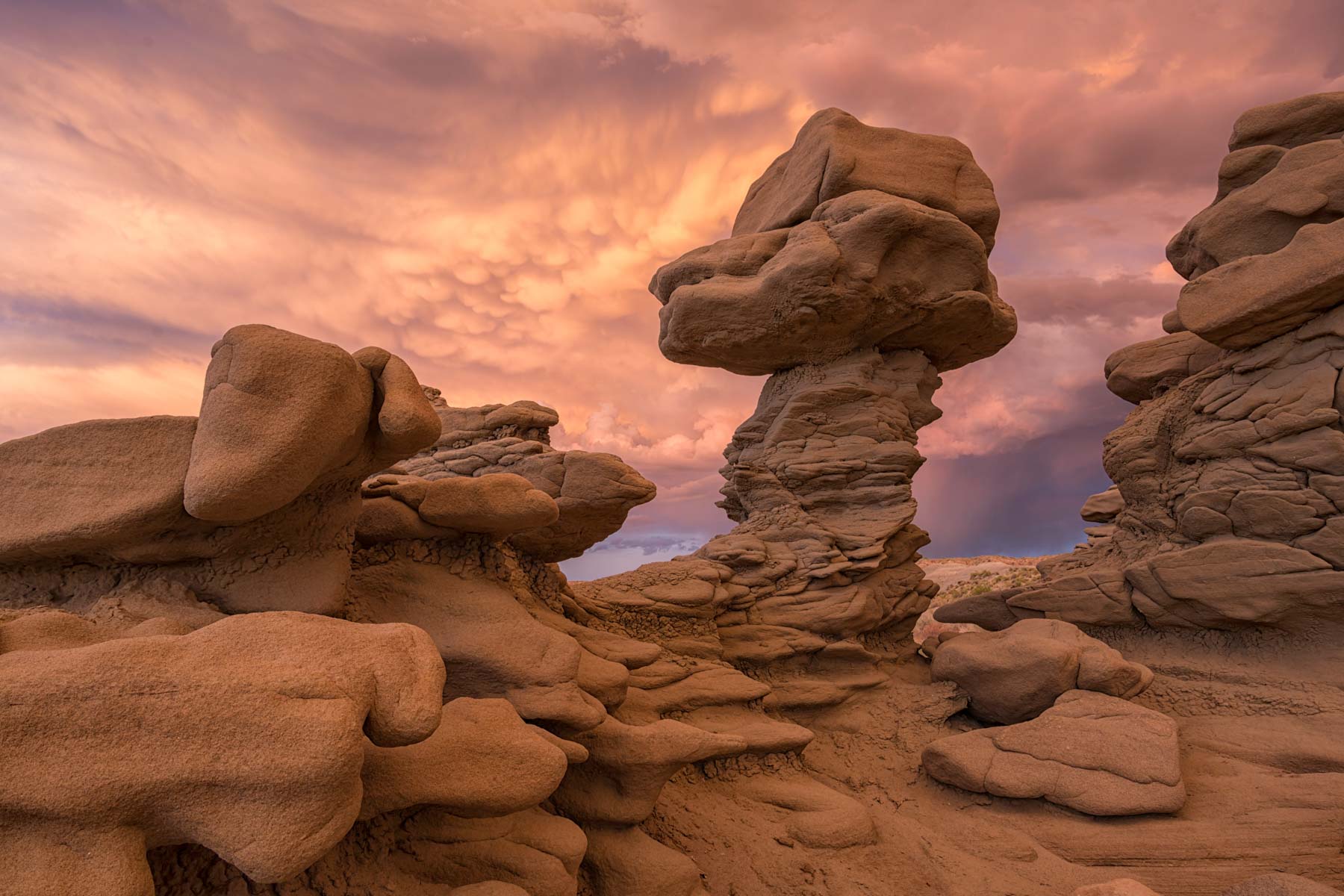
Fantasy Canyon
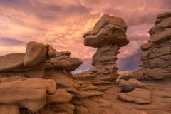
Fantasy Canyon Hoodoo
Fantasy Canyon is a small area of incredibly shaped sandstone figures about 40 miles south of Vernal, Utah. Though only a few acres in size there are strangely eroded rock figures everywhere. Fantasy Canyon is best known as the home of Teapot Rock made famous by Michael Fatali in his image "Back Of Beyond". Unfortunately Teapot Rock was damaged in 2006, probably by vandals, and Fantasy Canyon is no longer the attraction it once was. The rock in Fantasy Canyon is tan in color and only photographs well at sunrise or sunset when it gets a red glow. You can no longer camp overnight at the trailhead or its immediate surroundings which makes shooting at both sunrise and sunset difficult.
Below is the official Bureau of Land Management map as a jpeg and in four geocoded formats: as a GeoTiff, as a KMZ file, as a GeoPDF, and in Oruxmaps format. The image below displays in low resolution, choose one of the options below to download a full resolution 300dpi image.

- Click to download a GeoPDF file.
- Click to download a high resolution Jpeg file. File is not geocoded.
- Click to download a GeoTiff file viewable in PDF Maps
- Click to download a KMZ file viewable in Google Earth
- Click to download an Oruxmap file (Note - in IE Right Click and choose Save Target as)
Travel Directions
- Start at the intersection of US191 and US40 in Vernal.
- Turn right onto New Mexico 45 4.0 miles from Vernal.
- Take NM 45 20.3 miles to Glen Bench Road and turn right.
- Take Glen Bench Road 12.8 miles and turn left onto Coyote Washington Road (Fantasy Canyon Road). Drive carefully, this road gets a lot of heavy truck traffic.
- Follow the Fantasy Canyon signs 4.5 miles to Fantasy Canyon Parking.
Here is a Google Map of Northeast Utah including Fantasy Canyon.
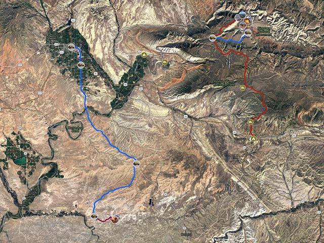
To view the map in Google Maps please click anywhere on the map above.
- Click to download a KMZ file (Note - in IE Right Click and choose Save Target as)
- Click to download a KML file (Note - KML files do not include custom icons)
- Click to download a GPX file (Note - in IE Right Click and choose Save Target as)
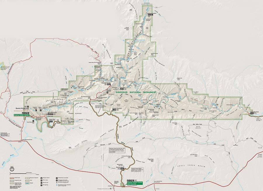
Dinosaur National Monument
Official Park Map
Below is the official Dinosaur National Monument map as a jpeg and in four geocoded formats, as a GeoTiff, as a KMZ file, as a GeoPDF, and in Oruxmaps format. The image below displays in low resolution, choose one of the options below to download a high resolution 300dpi image.
- Click to download a GeoPDF file.
- Click to download a high resolution Jpeg file. File is not geocoded.
- Click to download a GeoTiff file viewable in PDF Maps
- Click to download a KMZ file viewable in Google Earth
- Click to download an Oruxmap file (Note - in IE Right Click and choose Save Target as)
Photographing Dinosaur National Monument
There are two visitor centers in Dinosaur NM separated by about 30 minutes of driving. The westernmost visitor center is the Quarry Visitor Center near the small town of Jensen Utah. If you want to see dinosaur fossils start your visit here at the Quarry Exhibit Hall where there is a wall of naturally embedded fossils on display. The Quarry area is worth visiting but the fossils are not particularly photo worthy. Inside the park camping is available about ten minutes away at the Green River Campground.
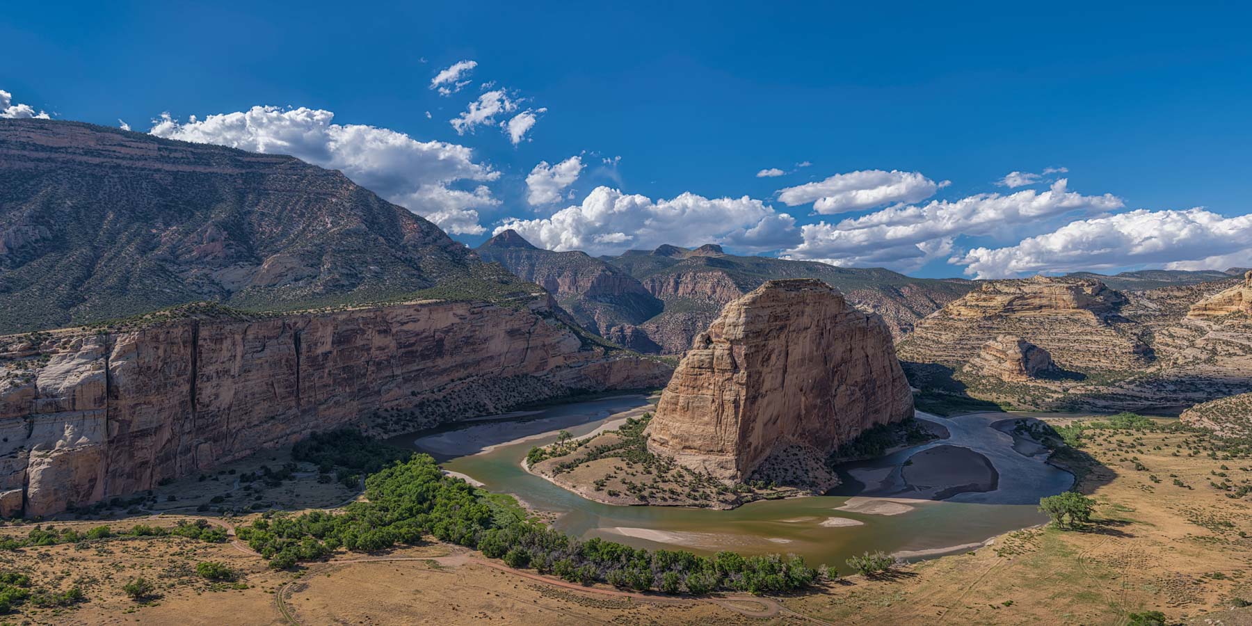
The Canyon Visitor Center in Dinosaur, Colorado is the gateway to the eastern side of the park. If you like photographing grand vistas you should visit Harpers Corner. Harpers Corner is about forty minutes north of the Canyon Visitor Center. The Harpers Corner overlook sits on a narrow ridge at about 7,600 feet in elevation. The Green River lies 2,500 feet below. An easy one mile hike takes you from the Harpers Corner parking area to the overlook. From the overlook to the west you can see the Green River as it winds its way through Whirlpool Canyon. To the east Green River curves around Steamboat Rock. The confluence of the Green and Yampa rivers is just barely visible from the overlook.
The highlight of the eastern portion of the monument is Echo Park. Echo Park sits at the confluence of the Green and Yampa Rivers. Access is via Echo Park Road, a four mile gravel road. A high clearance vehicle is recommended and signs state that campers and trailers are not recommended. While Echo Park road has a reputation for steep grades and sharp turns my 21 foot long F350 pop up camper I had no problems driving it. The road is impassable when wet, and may be closed or impassable in the winter.
There is a 22 site campground at Echo Park with running water, picnic tables, and vault toilets. The campground was about 50% full when we visited it in mid-July. Most of the campers had tents but there were a few pop up campers. Bring mosquito spray as the campground is very close to the Green River.
There are many photographs to be had in the Echo Park area:
- From the campground take a hard left at the exit onto the day-use road. After about .15 miles park either at the building on the right or take a left and park at the raft-launch. The reward for your long drive to Echo Park is good edge-on views of Steamboat Rock and its reflection in the Green River. You'll need to cross Pool Creek for the best views. There are logs to help with this.
- To view the confluence of the Green and Yampa rivers continue down the day-use road and park near its end. From here it is an easy 0.6 mile hike down a good path to the confluence.
- Whispering Cave gets great reflected light in the afternoon. Parking is 0.4 miles before the campground entrance on Echo Park Road.
- The Pool Creek Petroglyphs lie on a cliff-side high above Pool Creek. They were created by the Fremont people about 1,000 years ago. The petroglyphs are of two distinct designs. The dot-pattern or pointillist design sits above the more common chipped design on the rock face. A 200mm lens works well here. Parking is 0.9 miles before the campground entrance on Echo Park Road.
- There is a great view of the Green River bending around Steamboat Rock and the confluence of the Green and Yampa rivers from atop the cliffs to Steamboats south. Getting to the viewpoint requires a moderately difficult one mile hike. In my opinion the view here is just as good as the view at Horseshoe Bend and you are likely to have it all to yourself! The hike begins at Pool Creek Petroglyphs parking. From here walk up Echo Park Road 0.1 miles till you see a faint trail going up the hill to your left. Cross Pool Creek wherever you can and follow the faint trail up the steep hillside to the top. While on the hillside look left and you will see "Picasso's face" on the rock cliff. The view here is unobstructed and much better than the view from the road. Once gaining the top the trail becomes clearer, at least for a while. Follow it northeast to a deep drainage and cross the drainage wherever you can. The trail becomes fainter here; use a compass or GPS to head north to the rim. Mid to late afternoon works best here. Don't go too late or the left side of Steamboat Rock will be in partial shadow.

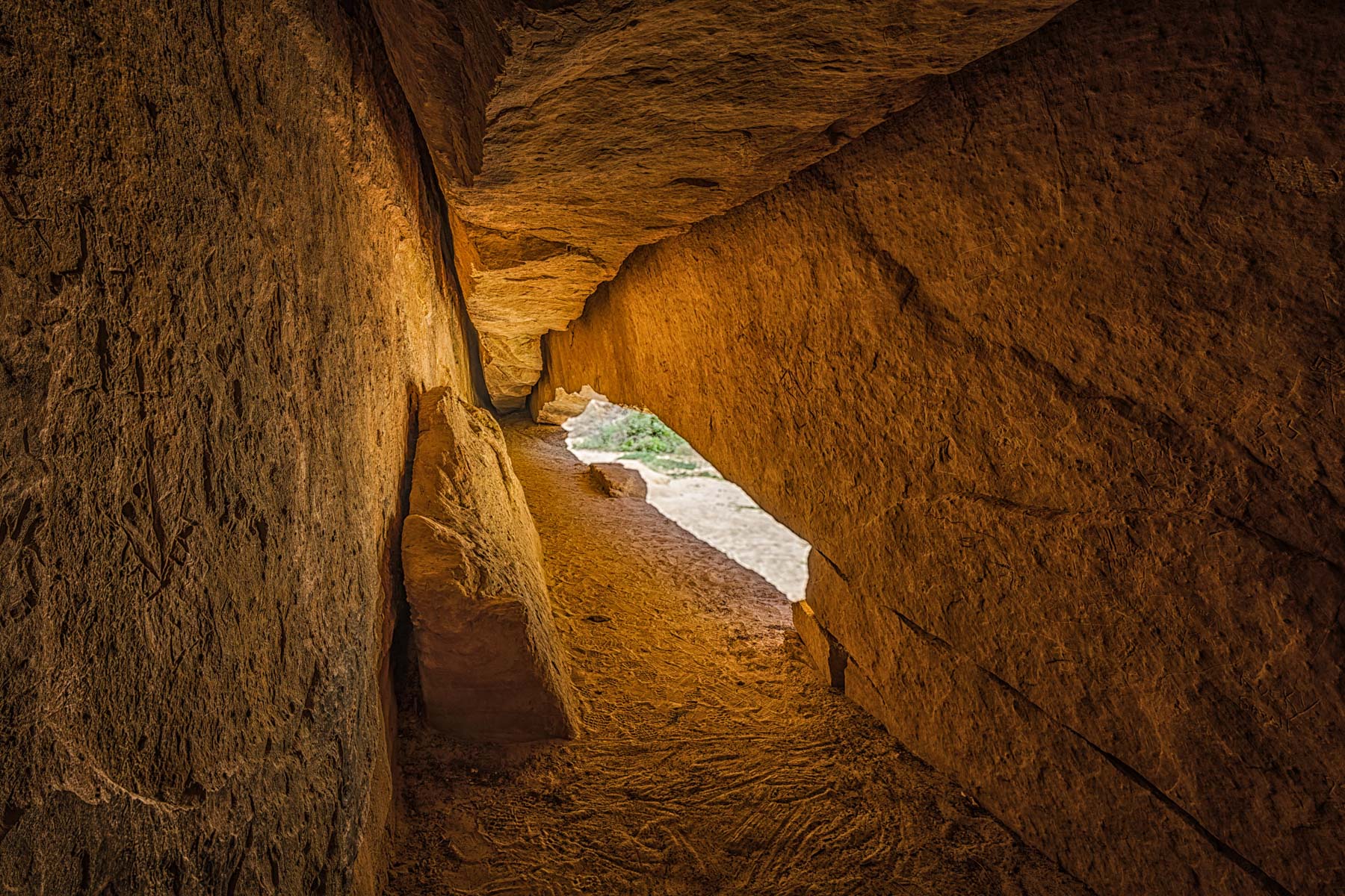
Whispering Cave
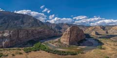
Steamboat Rock