The Tuba City Dinosaur Tracks and the surrounding area
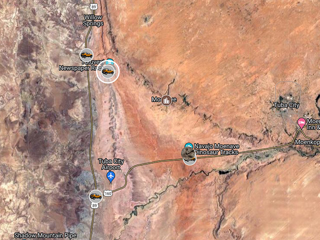
If you are driving through the Cameron or Tuba City area stops at the Tuba City dinosaur tracks and Tutuveni Newspaper Rock are worthwhile. Both locations have limited photographic appeal but have archeological and educational significance. The two locations are within 10 minutes of the intersection of Highways 89 and 160 and each can be visited in an hour or two.
The Tuba City Dinosaur Tracks
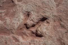
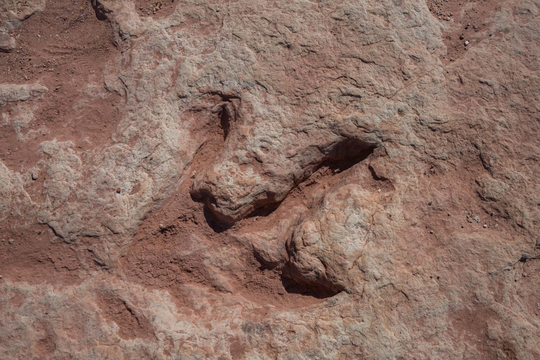
Dinosaur track at the Tuba City Tracksite
The Tuba City dinosaur tracks are six miles west of Tuba City. To get to the tracks from the intersection of Highways 89 and 160 take US 160 east for five miles and turn left onto Route 23, a good gravel road. Take 23 0.2 miles and park at the stands on the left. When present a Navajo guide will come out and greet you and take you to the tracks. I asked our guide if there was a fee, she just asked for "a good tip". I suggest leaviong a tip between $5 and $20 based on how many you have in your party and how knowledgeable the guide is. There is a short loop trail that passes many of the tracks. The site contains hundreds of well-preserved prints in a wide variety of sizes from four inches to two feet. The tracks are in Moenave sandstone and date to the early Jurassic period 200 million years ago. It is unknown which dinosaurs made the tracks.
Knowledge of the tracks varies greatly amongst the guides. Our guide stated that some of the rocks were dinosaur poop or eggs. My grandchildren were delighted by this. In reality neither was probably present. There are no known dinosaur eggs in North America from the early Jurassic. Dinosaur feces, known as coprolites, are not present at this site. Our guide also indicated that Tyrannosaurus Rex made one of the tracks. T Rex inhabited the earth starting about 90 million years ago. Their prints would never be found in Moenave sandstone. She also pointed out a human print was present, early humans lived about two million years ago in Africa.
Tutuveni Newspaper Rock
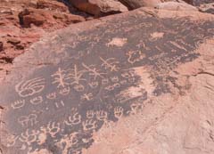
Hopi Clan Petroglyphs
The Tutuveni (Newspaper Rock) Petroglyphs, also known as the Hopi Clan Petroglyphs, are the largest known collection of clan petroglyphs. They date to 1200 AD. A Hopi Clan consists of relatives related maternally. Different Hopi clans have different symbols which they inscribe on rocks during their travels. The Hopi believe they originated through a hole or portal in the earth called a Sipapu. The Hopi Sipapu, or point or origin, is located several miles upstream of the confluence of the Colorado and Little Colorado Rivers. The Hopi Sipapu is a travertine dome and spring and is the source of the turquoise waters at the confluence. It is the most sacred shrine of the Hopi people. As a rite of passage young Hopi males would, over several days, hike from their homes on Black Mesa to the Sipapu and then on to the Grand Canyon before returning. On this hike they would pass the Tutuveni and leave their clan symbol. Over many generations each clan would leave a row of similar symbols, as seen in the image to the right.
The Tutuveni Petroglyphs are a World Monument Funds Site. There are more 5000 clan symbols at the site with most of the glyphs on eight boulders. There is a fence with a gate surrounding the petroglyphs. The site is on Navajo land and access requires permission from both the Navajo and Hopi. A permit can be picked up for $15 per person at the Cameron office of Navajo Parks and Recreation. On one occassion a native american woman was present at the site who granted us access. We gave her a tip. Many of the petroglyphs at Tutuveni are located on the tops of the boulders and are hard to see or photograph. Drones are not allowed in the Navajo Nation. A short stepstool or stepladder might be helpful if allowed.
To get to Tutuveni, take US 89 6.3 miles north from the intersection of US 89 and US 160. Turn right onto Route 23 and continue 1.3 miles to parking. Don't park too close to the fence, or your car may be in some of the pictures.
Climate
Tuba City, Arizona, is the closest town with available climate data. It is a few hundred feet higher than the dinosaur tracks and petroglyphs, so temperatures shown below are one to two degrees low. The following graphs are from weatherspark.com. In addition to the data shown here, Weatherspark includes data on wind direction.
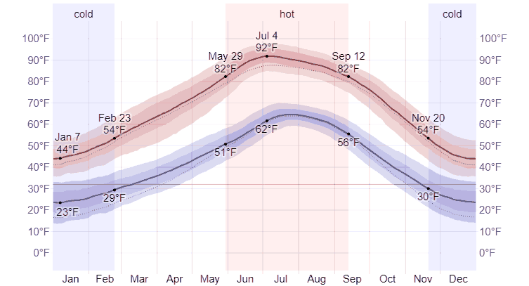
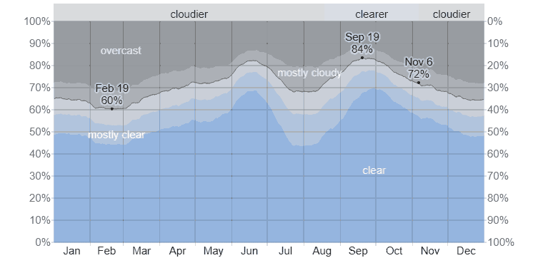
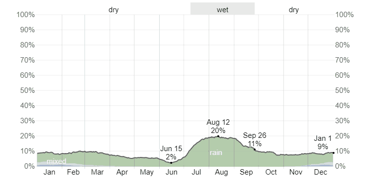
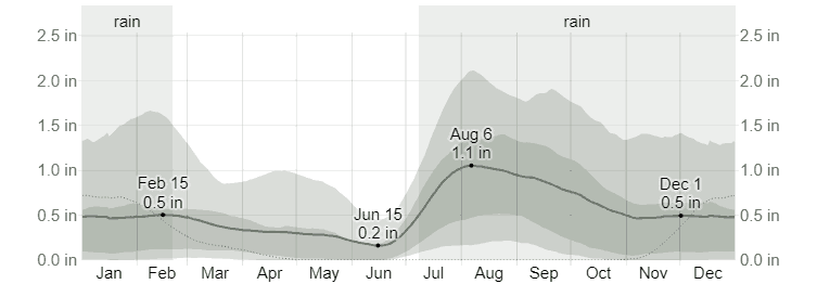
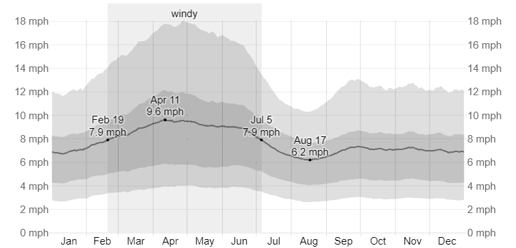
You can visit the Moenave area almost any time, with June being the driest month of the year. Dust storms in the area are common from early March through mid-June, so watch the wind forecast if you plan to visit then. The monsoon season runs from early July through mid-September. The dinosaur track area is flat, and your car is near, so this is a good place from which to shoot lightning in the summer safely.
Google map of the area
To view the map in Google Maps please click anywhere on the map above.