Wahweap Creek and the surrounding area
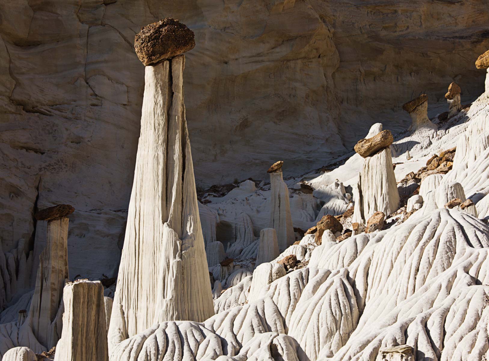
The hoodoos and balanced rocks along Wahweap Creek and Smoky Mountain Road are worth photographing and are accessible most of the year. There are several groups of hoodoos and mounds of white entrada sandstone along the west side of Wahweap Creek beginning about six miles from the town of Big Water. The best known of the hoodoos and the only one with a name is the "Tower of Silence" (aka "The White Ghost"). This hoodoo is best photographed when it is lit and the cliffs to its south are in shadow. This occurs within an hour or two of sunrise between April and September. If you are going to photograph the Tower of Silence I suggest you be there at sunrise. Unfortunately this requires a very early start as the hike to the hoodoo is four plus sandy miles one way.
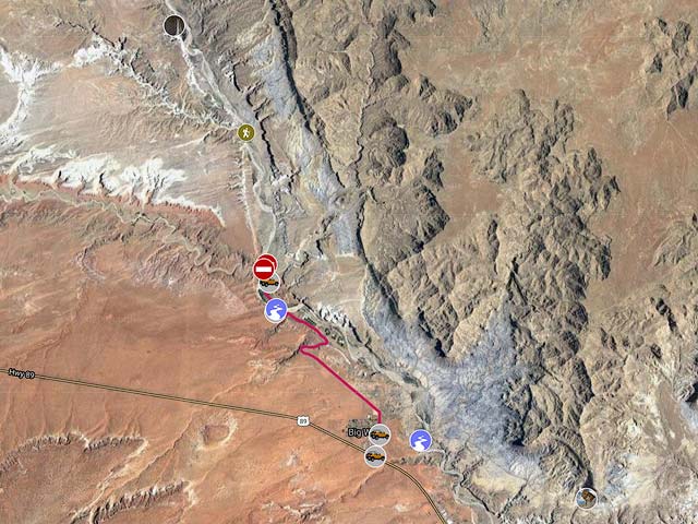
The Wahweap Creek trailhead is about four miles northwest of the town of Big Water. There are two trailheads, one for 2WD vehicles, and one for 4WD. Here are driving directions to the trailheads:
- Coming from Page take US 89 west 14.4 miles (measured from the Glen Canyon Visitor Center) to Ethan Allen Way in Big Water.
- Turn north at the intersection of Ethan Allen Way and Highway 89 in Big Water.
- Drive 0.6 miles and turn left onto Fish Hatchery Road.
- Continue 2.0 miles on Fish Hatchery Road to the Fish Hatchery. Fish Hatchery Road becomes Nipple Canyon Road here.
- After .5 miles Nipple Canyon Road becomes BLM327 / Nipple Creek Road.
- Continue .2 miles to Wahweap Creek and park on the right before the stream crossing. Begin your hike here.
- If you have a 4WD vehicle you can cut your hike by .5 miles one way by driving across Wahweap Creek and continuing .5 miles to the 4WD trailhead.
The hike to the Tower of Silence is unremarkable. It is level and sandy. Normally Wahweap Creek is dry and the hike itself is a bit of a slog with little to be seen. Two miles into the hike the West Fork of Wahweap Creek joins with Wahweap Creek from the left. If you take the West Fork for about two miles you will come to the mouth of Sidestep Canyon, and a bit further on there are spectacular hoodoos to the right. To get to the Tower of Silence continue to the right at the junction with the West Fork. After another mile hoodoos, cranberry colored conglomerates, and white mounds of sandstone appear in groups on the left side of the creek making the hike more interesting. The Tower of Silence is in the third group you come to, four plus miles from the 4WD trailhead, on the left side of the wash.
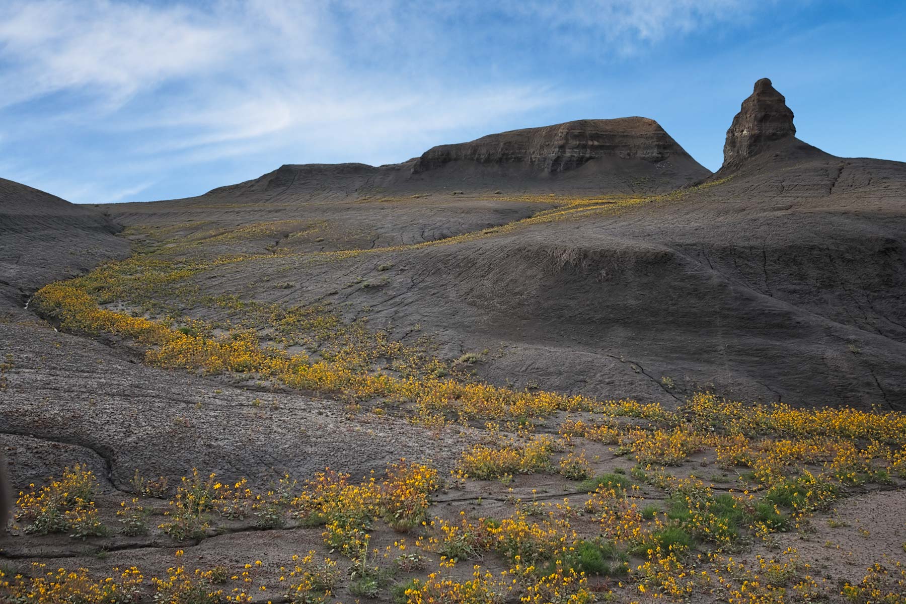
After your hike you may want to explore the badlands along Glen Canyon NP Road (NP230) which becomes Smoky Mountain Road. Glen Canyon NP Road is a good gravel road and 2WD is normally sufficient. To get to the badlands from the intersection of Ethan Allen Way and Highway 89 take Ethan Allen Way 0.3 miles and make a right onto Glen Canyon National Park Road. In another 0.5 miles you will reach Wahweap Creek which normally has a little water in it. It should be easy to cross. Continue along NP230 for 2.6 miles to Diamond Rock on the left. In late April the badlands along Glen Canyon NP Road occasionally produce a spectacular display of yellow wildflowers. This is quite rare, remember that the Page area only gets about six inches of rain in a normal year.
Google Map of Wahweap Creek
Here is an Google overview map showing how to get to the Tower of Silence:
To view the map in Google Maps please click anywhere on the map above.
USGS 24K Topo Maps
The Wahweap Creek area and the badlands along lower Smoky Mountain Road are covered by four USGS 24K maps.

Wahweap Creek Point Index Map
| Geo Tiff/Avenza | KMZ | Oruxmaps | KMZ Decollared | Oruxmap Decollared | Avenza Decollared |
| Big Water | KMZ | Oruxmap | KMZ Decollared | Oruxmap Decollared | Avenza Decollared |
| Lone Rock | KMZ | Oruxmap | KMZ Decollared | Oruxmap Decollared | Avenza Decollared |
| Nipple Butte | KMZ | Oruxmap | KMZ Decollared | Oruxmap Decollared | Avenza Decollared |
| Tibbet Bench | KMZ | Oruxmap | KMZ Decollared | Oruxmap Decollared | Avenza Decollared |
| Merge of all four maps | NA | NA | KMZ Decollared | Oruxmap Decollared | Avenza Decollared |