Mono Lake
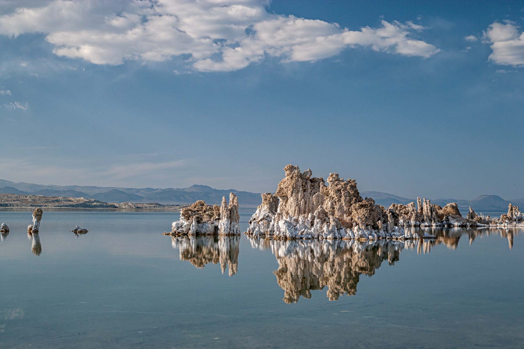
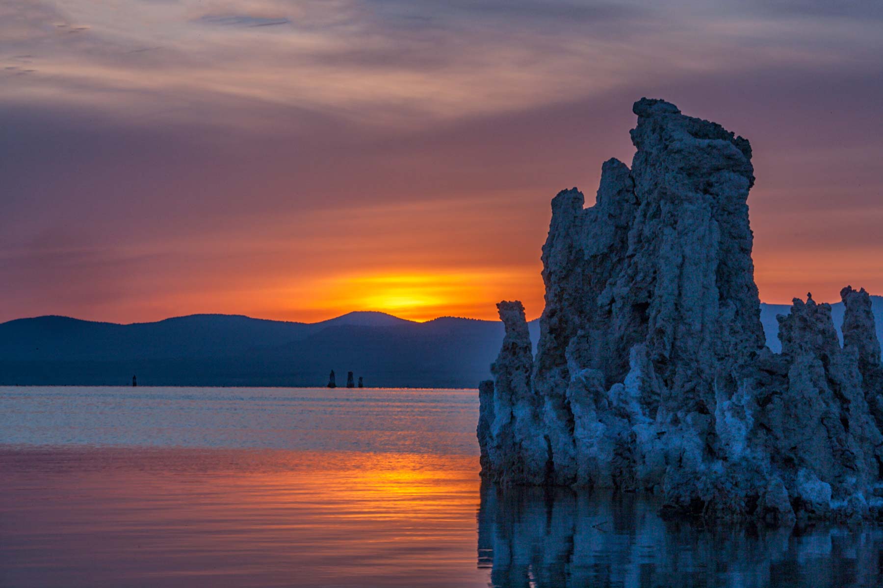
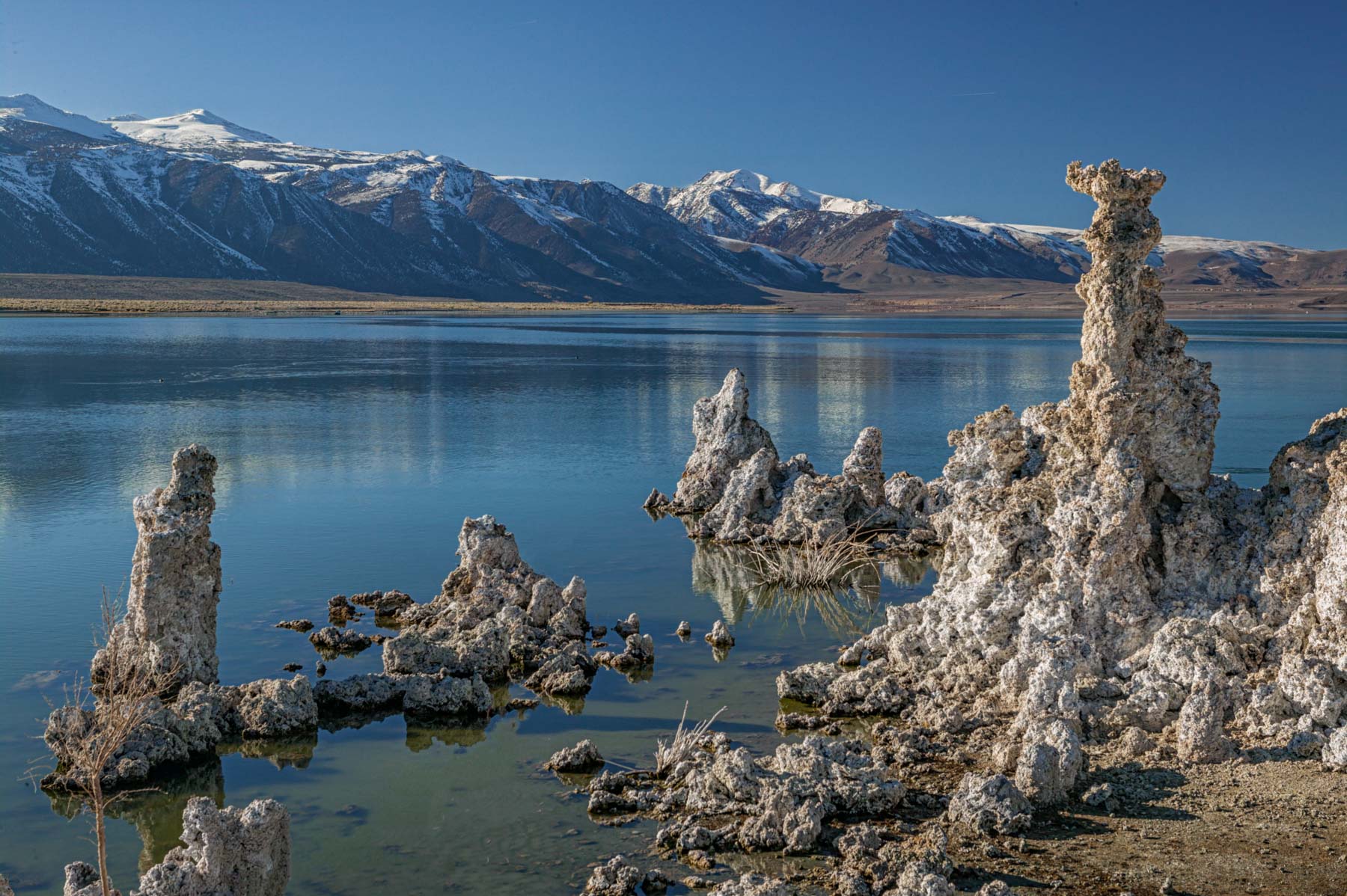
Mono Lake is a photogenic lake with no outlet east of Yosemite National Park. The lack of an outlet results in the lake's high salt and calcium carbonate levels. Over a long period, the calcium carbonate in the lake precipitated out, forming under-water limestone columns known as tufas (pronounced toofuhs). When lake levels drop, the tufas are exposed along the shore.
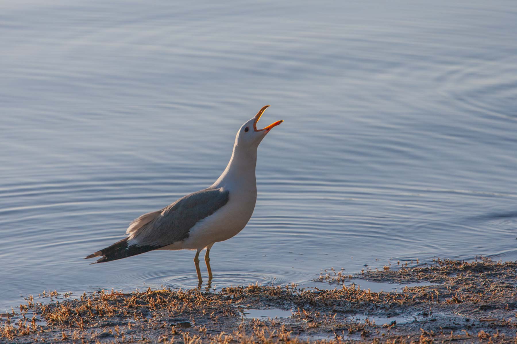
Mono Lake is the temporary home to two million migratory birds yearly. The birds feed on brine shrimp, and black alkali flies. The black flies are everywhere. On the west shore, I have seen them form a black carpet that parts as you walk on it. Alkali flies feed on algae and do not bite humans. Walking on the fly carpet is disgusting but perfectly safe, and the flies do not bite. California Gulls can be seen walking on shore or flying with their mouths open to catch the black flies. After the Great Salt Lake, Mono Lake is the largest California Gull rookery in the US. Because California Gulls also feed on crickets, which are very destructive to crops, the gulls are the state bird of Utah. California Gulls begin arriving at Mono Lake in late Spring and return to the California seacoast by winter.
Photographing Mono Lake
The South Tufas at Mono Lake are a great photographic destination at sunrise and sunset. Shoot the tufas and their reflections on the lake. I suggest you walk through the black flies and into the lake to get the best compositions. Getting close to your subject often results in the best images! Bring flip-flops, water shoes, or something more sturdy to protect your feet from sharp limestone edges below the water's surface.
Mono Lake is just east of the Eastern Sierras. The Eastern Sierras generate dramatic cloud formations on good days. The Sierras will be snow-covered from late fall to mid-spring, making this a good time to shoot.
At sunset, shoot west for color in the sky and reflected color on the tufas and lake. The tufas themselves will be in the shadow of the Eastern Sierras well before sunset.
At sunrise, the lake surface will often be calm, resulting in great reflections. Alpenglow will be present on the Sierras. The blue hour works well, even on clear days, and is my favorite time to shoot at the lake. Use a polarizer to minimize glare on the tufas or to adjust the amount of reflections.
The South Tufas at Mono Lake are not a great Milky Way destination as you will usually be shooting towards the north or west.
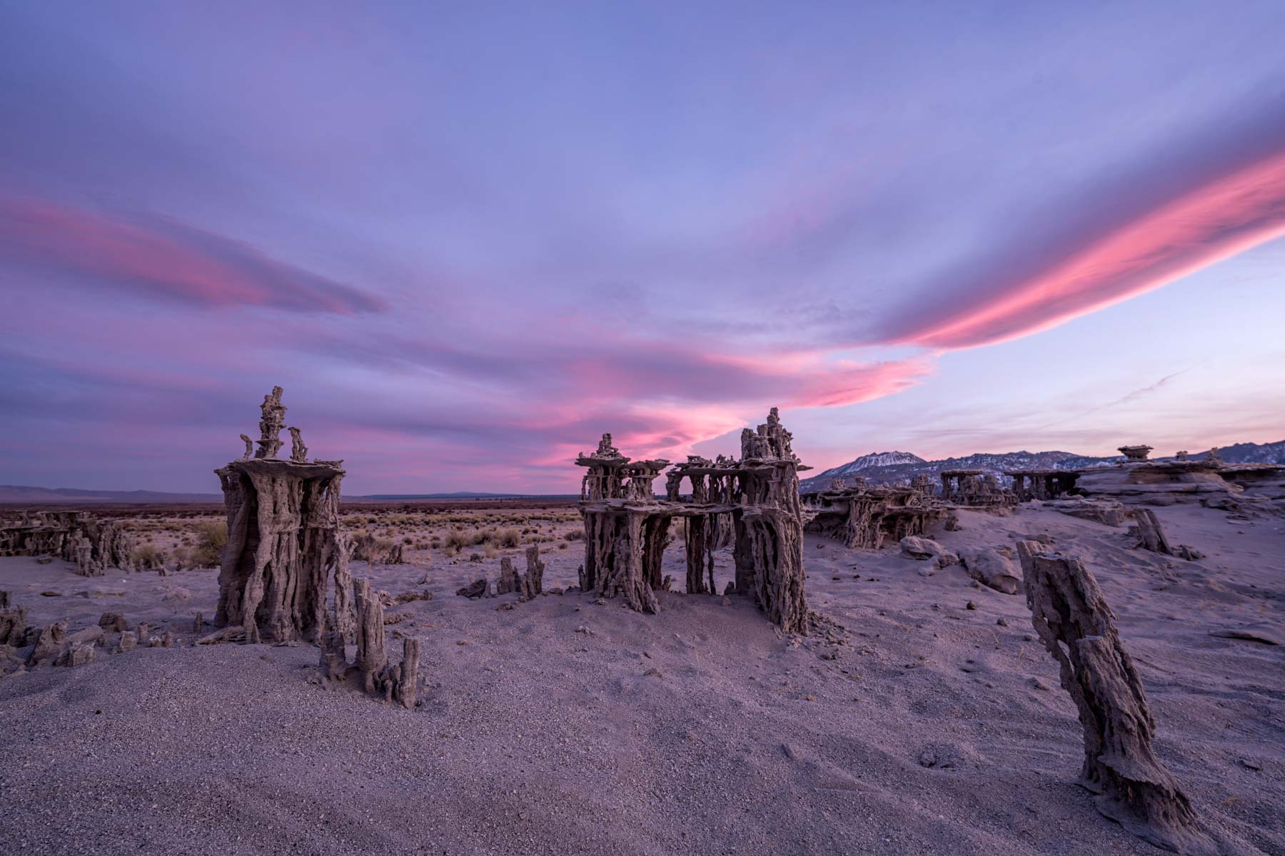
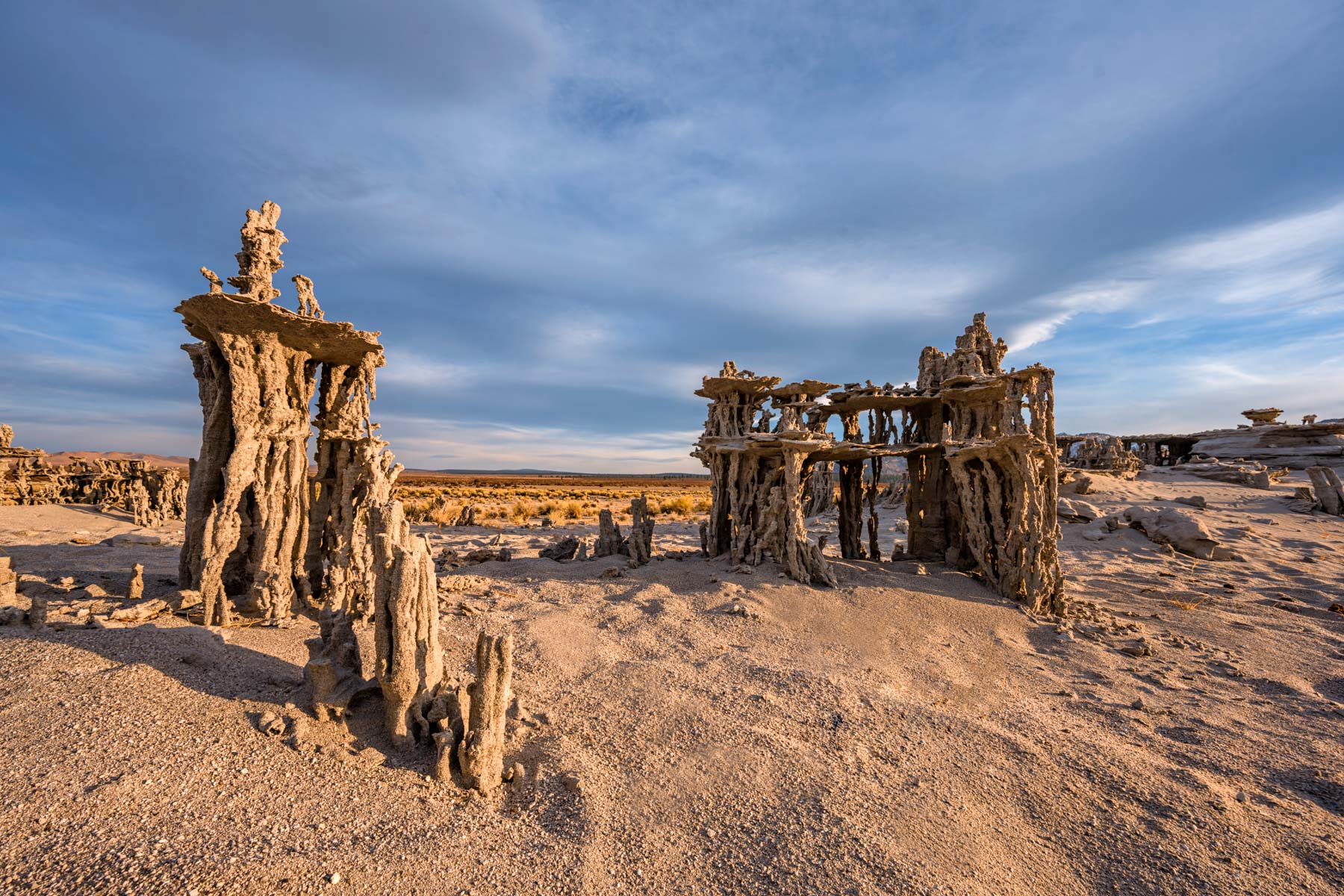
The Sand Tufas near Navy Beach are also good subjects. These tufas are 50-100 meters inland from the lake, so Mono Lake will not be in your image. While the South Tufas are large and rock-like in appearance, the Sand Tufas are delicate and have many branches. They form fantastic shapes and are best photographed up close. If possible, shoot at sunrise after a windy night so that the footprints around the tufas are filled in. Deep footprints were everywhere when I was at the Sand Tufas, and the footprints were impossible to remove in post. I found focal lengths around 24mm worked very well. You will need to focus bracket. There are two groups of Sand Tufas. The ones to the east are only one or two feet high but form fantastic shapes. This spectacular image by Canon Explorer of Light Erin Babnik shows the possibilities at the eastern Sand Tufas.
The Sand Tufas to the west are taller but not as shapely. Both sets of Sand Tufas should work well as foreground for Milky Way photography.
Other photogenic areas near Mono Lake include the Yosemite high country, Bodie ghost town, and the many lakes along the Eastern Sierras. These lakes include Lundy Lake, June Lake, Mammoth Lakes, Virginia Lake, and Convict Lake. All are spectacular when the aspens are changing color in mid-late September.
The use of unmanned aircraft (also known as drones) is not permitted over the surface of Mono Lake and all shoreline lands managed by California State Parks except by special use permit.
Camping
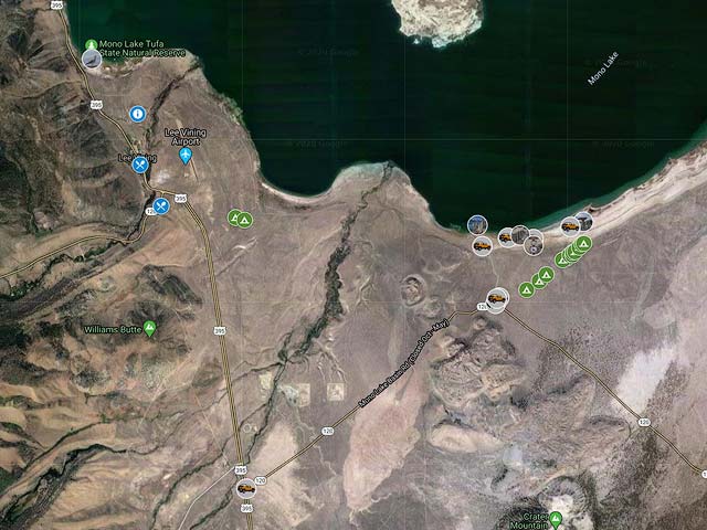
The immediate area around Mono Lake is a California State Park, and all camping within the park is prohibited. The area just outside the state park is National Forest Service land, and free camping is allowed. There are no services. An NFS permit is needed for campfires. I have shown a boundary marker between the State Park and National Forest lands on the Google map below. The boundary is roughly where the shorter vegetation ends and taller vegetation begins. I have also shown the location of some possible small RV or tent campsites. You may need a 4x4 to access these sites, as roads in the area are very sandy. If you stop by the National Forest Service Mono Basin Scenic Area Visitor Center, they should be able to recommend campsites and provide campfire permits. The visitor center is not open during the winter. The website freecampsites.net lists many other campsites in the area.
When to Go
At 6,400 feet elevation, Mono Lake has cold winters and mild summers. Snow is common during the winter, with over a foot falling on average each month from December to March. If you plan to go in winter, I suggest you check the snow depth first. You can find estimated snow depth at the Mono Lake South Tufas parking lot at Windy.Com or at Weatherstreet.com. Windy.com provides snow depth information for worldwide locations. Both ECMWF and Icon projections are available. You can select the model via the box on the lower right on Windy.com. A color overlay shows estimated snow depth at map zoom levels of 11 and lower. The color legend appears at the lower right on windy.com. For zoom levels 12 and higher, right-click on the map and choose "Show Weather Picker." Grid spacing for the ECMWF is 9km as of 2023. Grid spacing for the Icon model is 13km. Both models show projections for snow density. Densities of 100-200 are typical of fresh snow (powder), and 200-300 or more are typical for wet or compacted snow. Wet snow is generally harder to drive and walk on as it ices up. Weatherstreet provides estimates of snow depth for US locations by zip code. On weatherstreet.com, enter a zip code followed by the word snow in the search box at the upper right. Another good source of current information for Mono Lake is Twitter . Highway CA 120 may be closed in the winter, and US 395 sometimes closes or is difficult to drive. Services at Mono Lake are limited during the winter. The Whoa Nellie Deli (perhaps the best restaurant in Lee Vining) is not open from mid-November through mid-April. The good restaurant Nicely's is open throughout the winter months. The high country of Yosemite is inaccessible during the winter, and Bodie Ghost Town is normally accessible only by snowmobile or skis.
I believe the best time to visit Mono Lake is early fall when the aspen in the area are changing.
| Jan | Feb | Mar | Apr | May | Jun | Jul | Aug | Sep | Oct | Nov | Dec | Annual | |
| Average Max. Temperature (F) | 40.5 | 44.7 | 50.7 | 58.6 | 67.6 | 76.8 | 83.9 | 82.6 | 75.8 | 65.5 | 51.7 | 42.2 | 61.7 |
| Average Min. Temperature (F) | 19.7 | 21.6 | 24.9 | 29.6 | 36.4 | 43.2 | 49.6 | 49.0 | 42.7 | 34.5 | 27.3 | 21.8 | 33.4 |
| Average Total Precipitation (in.) | 2.19 | 2.18 | 1.39 | 0.67 | 0.58 | 0.35 | 0.57 | 0.46 | 0.64 | 0.65 | 1.96 | 2.32 | 13.96 |
| Average Total Snowfall (in.) | 15.5 | 14.6 | 11.2 | 3.1 | 0.4 | 0.0 | 0.0 | 0.0 | 0.0 | 0.8 | 7.6 | 12.0 | 65.3 |
| Average Snow Depth (in.) | 5 | 6 | 3 | 0 | 0 | 0 | 0 | 0 | 0 | 0 | 1 | 2 | 1 |
Maps
To view the map in Google Maps please click anywhere on the map above.
USGS 24K Topo Maps
The six maps below cover all of the Mono Lake area. The topo map "Lee Vining" covers the South Tufas and the western Sand Tufas, the eastern Sand Tufas are covered by the Mono Hills map.
The table to the right contains the topo maps in a variety of formats. KMZ overlay files can be opened with Google Earth, and Oruxmap files can be opened with Oruxmaps, a free mapping app for android phones and tablets. USGS topo maps contain a white border (called the collar) which contains information such as the map name, names of neighboring maps, date the map was created, latitude and longitude reference lines, ... While collars are very useful on printed maps, the information on the collar is much less useful for computer use. Maps with the collar removed can also be downloaded in the table to the right.
For reference there is an image below showing the names of the six Mono Lake topo maps and their locations. Click on the image to view it larger. The topo maps can be downloaded to the right of the image.
Mono Lake Index Map

| Geo Tiff/Avenza | KMZ | Oruxmaps | KMZ Decollared | Oruxmap Decollared | Avenza Decollared |
| Lee Vining | KMZ | Oruxmap | KMZ Decollared | Oruxmap Decollared | Avenza Decollared |
| Lundy | KMZ | Oruxmap | KMZ Decollared | Oruxmap Decollared | Avenza Decollared |
| Mono Mills | KMZ | Oruxmap | KMZ Decollared | Oruxmap Decollared | Avenza Decollared |
| Mount Dana | KMZ | Oruxmap | KMZ Decollared | Oruxmap Decollared | Avenza Decollared |
| Negit Island | KMZ | Oruxmap | KMZ Decollared | Oruxmap Decollared | Avenza Decollared |
| Sulfur Pond | KMZ | Oruxmap | KMZ Decollared | Oruxmap Decollared | Avenza Decollared |
| Mono Lake Area | NA | NA | KMZ Decollared | Oruxmap Decollared | Avenza Decollared |