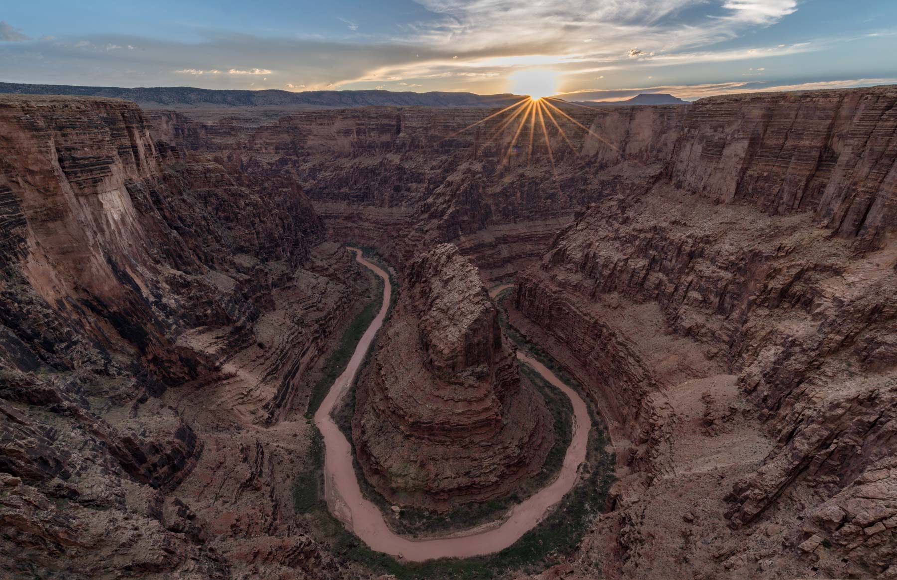
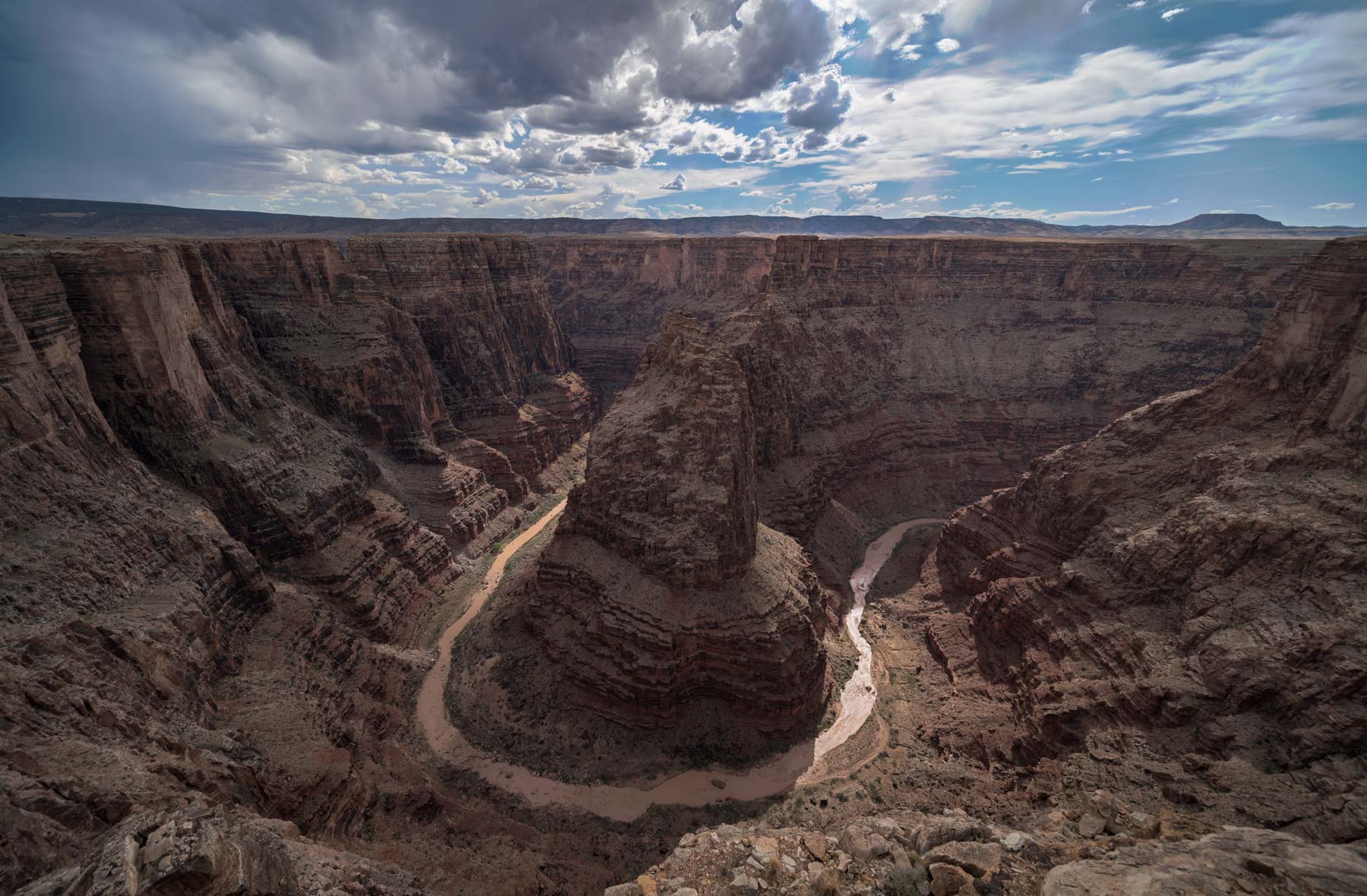
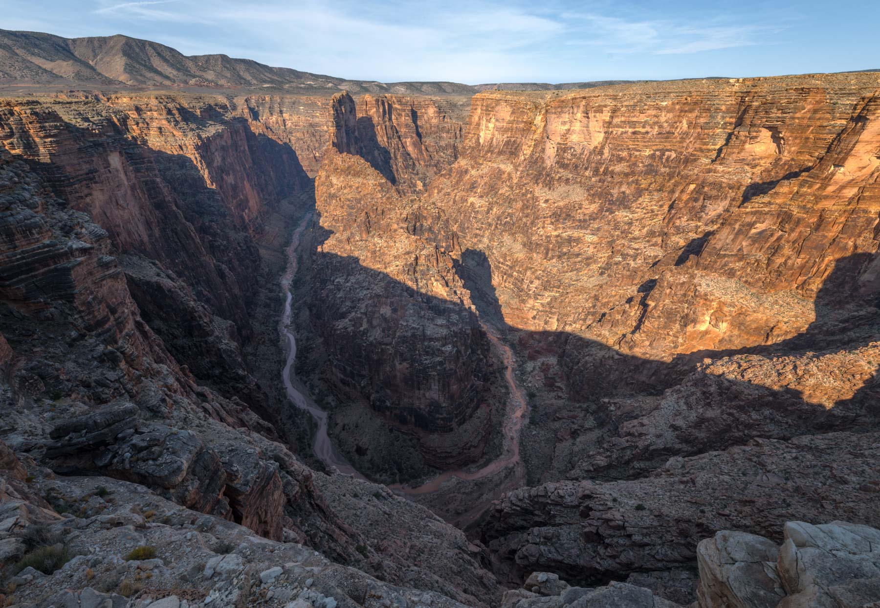
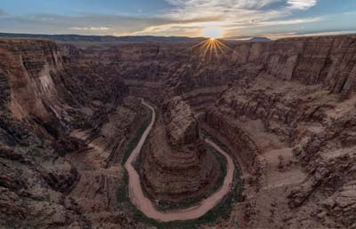
Five Bends of the Little Colorado River
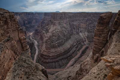
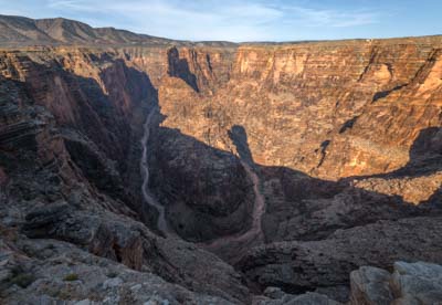
While other sections of the Little Colorado river (e.g. Grand Falls and the confluence with the Colorado river) are well known, the section of the river between Cameron and the Hopi Salt Trail is rarely visited. This is unfortunate since this part of the Little Colorado River (LCR) Gorge contains a great many "Horseshoe" like bends, and walls that tower 2,000 feet above the river. For comparison, the vertical drop at "Horseshoe Bend" is 1,100 feet. I recently visited the upper part of the LCR's northeast rim west of Cameron. This area contains five photogenic bends in the river. The closest one to Cameron is the only one with a name, "Hellhole Bend". The others I've simply called the First, Second, Third, and Fourth Bends.
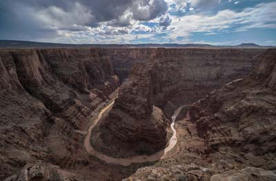
A walk across Hellhole Bend
Hellhole Bend is best known as the place where Nik Wallenda tightroped across the "Grand Canyon" in 2013. This incredible feat was done on a two inch round steel cable 1400 feet long with a vertical drop of 1,600 feet. The walk was done unprotected! Of course most people do not consider the LCR Gorge part of the Grand Canyon, however the USGS does consider the gorge to be part of the Grand Canyon geological area. It is unlikely the National Park Service will ever grant permission to tightrope across Grand Canyon National Park so this walk is probably as close as anyone will ever get.
The walk began from an island butte just south of Hellhole Bend and ended on the Highway 64 side of the LCR. The island butte is only accessible by helicopter. The event was televised on the Discovery Channel. It was the highest rated live show ever broadcast on Discovery. An except of the walk can be viewed to the left or on Youtube as can an excerpt narrated by comedian Bill Burr. You need to fast forward the Bill Burr video a bit to view the LCR section.
In 2003 High-wire artist Philippe Petit had planned to cross the LCR in the same location as Nik Wallenda did. Philippe is best known for walking between the World Trade Center towers in 1974. Many years later he saw the LCR gorge from the air and began preparations to cross it. Unfortunately his funding fell through and the crossing was abandoned, as was some equipment. The left-over equipment was later removed by Nik Wallenda's crew as part of the Navajo Nation's permit conditions for the LCR crossing. Reportedly Philippe was angry that Nik Wallenda stole his idea. Wallenda claimed he had no prior knowledge of Petit's planned crossing.
Warnings
The LCR gorge and its rim are dangerous places. It is 2,500 feet from the rim to the floor of the gorge so be very careful near the edge. Make sure you're not standing on an overhang before venturing onto the rim. A few months ago a section of the rim at Horseshoe Bend collapsed and someone died as a result. Hellhole Bend may have been named for the sinkholes present in the area. If you hike out after sunset you may not see them. In 2007 German physicist Reinhard Kirchner went missing in the Hellhole Bend area and was never found despite an extensive search. It is believed he may have fallen into one of these sinkholes. Reinhard was a fit and skilled hiker who had been to the LCR Gorge several times before.
The drive to the rim, although relatively easy in dry conditions, may have washouts and ponds on the roadway following a rain. You should have a shovel in your car for washouts. The area is remote and cell service is limited. If your car gets stuck in mud or breaks down it may be several days before help arrives, so have plenty of water with you, at least five gallons in the summer months. I carry more.
There are no routes into the gorge from Hellhole Bend or the other three bends shown. Downstream there are five routes into the gorge in total, all but one of which are considered difficult. I have shown the two easiest on the map below. The Horse trail is the easiest and shortest route to the river, 2.2 miles one way with 1,700 feet of elevation loss. The trail takes you to a point five miles above Blue Spring, so the river will be muddy brown when flowing. Most people taking the Horse trail would do it as a backpack hiking downstream past Blue Spring and possibly exiting via the Hopi Salt Trail. A two car shuttle would be needed for this loop, or a mountain bike. When hiking in the Little Colorado watch for quicksand. It is very hot in the LCR Gorge in summer so bring plenty of water. You should cache some for the strenuous return trip. Hike Arizona rates the difficulty of hike as 3.5, the difficult side of moderate. When hiking the trails down to the Little Colorado make sure you find the cairns, if you haven't seen one in several minutes go back to the last one found and search again. Also look across ravines for the next cairn. At the very least going off-trail on these routes will be time consuming, in the worst case losing the route could be fatal.
The Hopi Salt Trail, also known as the Salt Trail Canyon trail, is the most commonly used route into the gorge. This is true despite its difficulty (rated 4.0 by Hikearizona). Three of my friends have done the hike, all have said it was very difficult with exposure. Finding the route in places was hard. One friend suggested you bring gloves as scrambling is needed and the Kaibab limestone is very sharp. The trail can be done in one day, but it will be a long one. I suggest you camp overnight at the river before heading back up the trail. You'll want to take the Hopi Salt Trail at least ten days after the Little Colorado has flowed in Cameron, so that only turquoise water is present downstream of Blue Spring. Water flow in Cameron can be checked at this link. This summer (2018) the Hopi Salt and all other trails into the LCR gorge were closed by the Navajo Nation due to excessive heat. The decision to close the area was also influenced by the many people who have been going into the LCR Gorge without a Navajo nation permit. You need a $12.00 per person per day permit to hike or backpack on Navajo Land. Permits can be obtained online at https://navajonationparks.org/permits/ or in person at the Cameron Visitor center at the southwest corner of the intersection of Highway 64 and US 89. In the summer months the Cameron visitor center is open seven days a week. A Navajo law enforcement ranger is sometimes present near the foot of the Salt Creek trail. If you do not have a permit he may prevent you from reaching the river whose aquamarine colors are the highlight of the trip. Permits may also be checked by the leaseholder of the land between the First and Fourth bend. I have been to this area three times, and each time I have seen the leaseholders who carefully checked my permit. I believe they are in the area every day to check on their cattle.
The other three routes into the gorge are much more difficult. The easiest is the Blue Spring trail which, unlike the others, starts on the west rim. The trail is "insanely" difficult with exposure, and protection may be necessary in places. Lines are needed to lower packs. The Walter Powell route from the confluence is rated a five for difficulty and involves several downclimbs. Ropes may be necessary. The Big Canyon trail is the longest and most difficult route into the gorge, and involves several rappels.
Base jumping and wingsuiting into the LCR Gorge are very popular, and illegal. In 2012 a Norwegian base jumper died in the Salt Trail Canyon area after he hit a rock and his parachute subsequently failed to open fully. In 2014 a base jumper died from impact in the confluence area. Rock climbing, base jumping, and wingsuiting have been illegal in the Navajo Nation since 2009, and are also banned in the Grand Canyon. When in the LCR area please have a permit, respect Navajo traditions and laws, try not to spook sheep or cattle thereby forcing herd checks and roundups to occur over a much wider area, and practice leave no trace. Tourism in the Navajo Nation is exploding, and the traditional Navajo ranchers along the LCR are only slowly adapting to this. Unless we respect the laws and traditions of the Navajo I believe the LCR area will be closed completely to visitors. The entire Kaibeto chapter of the Navajo Nation has been closed for years, primarily due to legal liability and the high costs of repeated search and rescue operations in Kaibeto canyon.
Photography
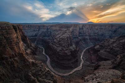
Late afternoon, sunset, and the blue hour are the best times to shoot the LCR bends from the rim. The Kaibab limestone on the rim of the Little Colorado is light colored and contrasty. It looks its best when in shadow near sunset or in the blue hour. Go in early spring or summer when the Little Colorado is flowing, as the river bed will be more reflective and better-defined when water is in it. The presence of a dramatic sky or lightning will greatly help your images, so summer is my favorite time to visit. For foreground look along the rim for century plants, cactus, or water pools. While you normally will be shooting to the west there are some places along the rim where you can shoot to the southeast or south, so Milky Way shots are a possibility. A wide to ultra-wide angle lens is needed to capture the entirety of the bends. Most of my images were shot at 12mm on a full frame camera.
Of the five bends I've visited I like the third bend the best, followed by the first. The fourth bend is difficult to shoot without obstruction. There is a broad wash entering the LCR from the northeast at Hellhole Bend, you need to shoot from the southeast side of the wash or your view will be obstructed.
If you plan to hike into the gorge you should wait at least ten days after flow has ended in Cameron, so that the water below Blue Spring will be turquoise. A six stop ND filter will help slow down exposure times enough to give the LCR rapids a creamy look. Use a polarizer to eliminate glare from wet rocks.
Map and Directions
The map below shows the drives to Hellhole Bend and four other LCR overlooks. It takes less than one hour to get from Cameron to the area with the bends. A high clearance 2WD vehicle is sufficient. The map also contains directions to the Hopi Salt and Horse trail trailheads, and the routes they take down to the Little Colorado. Routes shown are approximate and do not take the place of common sense. You need to follow the cairns religiously along both trails.
Note that the new Google maps engine does not show you the latitude/longitude of waypoints or points of interest, elevation, or the distance between two points on the map. The engine also does not show track or route elevation profiles. If you need these I suggest you download the KML or KMZ file for the map and load it into Google Earth or another mapping tool.
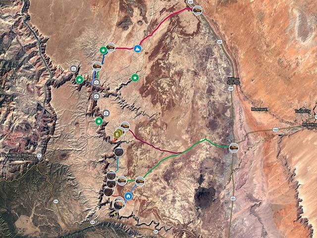
To view the map in Google Maps please click anywhere on the map above.
- Click to download a KMZ file (Note - in IE Right Click and choose Save Target as)
- Click to download a KML file (Note - KML files do not include custom icons)
- Click to download a GPX file (Note - in IE Right Click and choose Save Target as)
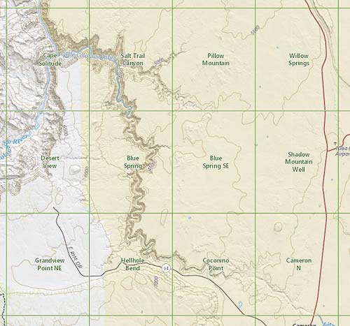
USGS 24K Topo Maps
The Little Colorado Gorge from Cameron to the foot of the Hopi Salt Trail is covered by three topo maps, and the side roads leading to the rim overlooks by another three. Below is an image showing the names of the six topo topo maps and their locations.
Individual and a merged topo map can be downloaded in a variety of formats by clicking or right-clicking below. When planning a trip to the area I suggest you download both the topo maps and the KML / GPX files above so that you do not get lost in the maze of ranch roads leading to the various overlooks. Note that some of the roads on the USGS maps no longer exist or have not been used in a very long time. Conversely some of the roads on the Google map do not appear on the USGS topo maps.
Little Colorado River Index Map
| Geo Tiff/Avenza | KMZ | Oruxmaps | KMZ Decollared | Oruxmap Decollared | Avenza Decollared |
| Blue Spring | KMZ | Oruxmap | KMZ Decollared | Oruxmap Decollared | Avenza Decollared |
| Blue Spring SE | KMZ | Oruxmap | KMZ Decollared | Oruxmap Decollared | Avenza Decollared |
| Coconino Point | KMZ | Oruxmap | KMZ Decollared | Oruxmap Decollared | Avenza Decollared |
| Hellhole Bend | KMZ | Oruxmap | KMZ Decollared | Oruxmap Decollared | Avenza Decollared |
| Pillow Mountain | KMZ | Oruxmap | KMZ Decollared | Oruxmap Decollared | Avenza Decollared |
| Salt Trail Canyon | KMZ | Oruxmap | KMZ Decollared | Oruxmap Decollared | Avenza Decollared |
| Merge of All six Maps above | NA | NA | KMZ Decollared | Oruxmap Decollared | Avenza Decollared |