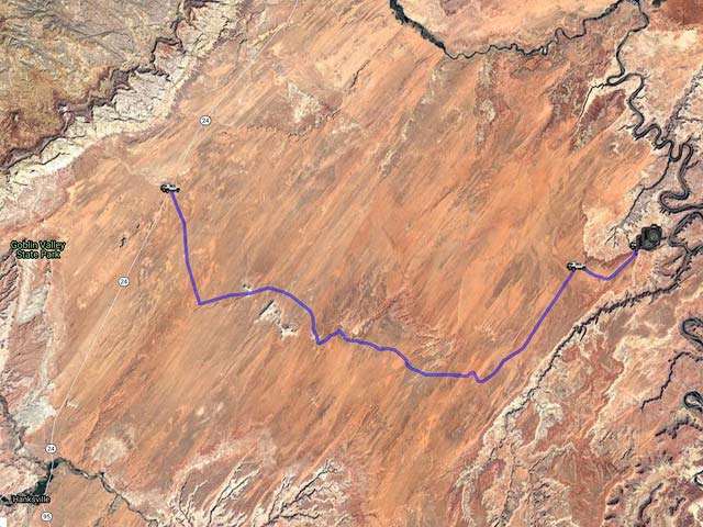
Hanksville, Utah Area
The Hanksville, Utah area is very scenic and includes the badlands near Caineville and Factory Butte to the west, Goblin Valley, the San Rafael swell and Greater Canyonlands to the north, and Arsenic Arch, Little Egypt, Leprechaun Canyon, Burr Point, and Hog Springs to the south.
Areas South of Hanksville
Utah State Route 95 provides access to the region, known for its many slot canyons, including Leprechaun Canyon. The area also features narrows suitable for hikers. Other notable sites from north to south are Burr Point, Arsenic Arch, Little Egypt, North Creek, and Hog Wash.
Here is a map showing the locations of the above:

To view the map in Google Maps, please click anywhere on the map above.
- Click to download a KMZ file (Note - in IE, Right Click and choose Save Target as)
- Click to download a KML file (Note - in IE Right Click and choose Save Target as)
- Click to download a GPX file (Note - in IE, Right Click and choose Save Target as)
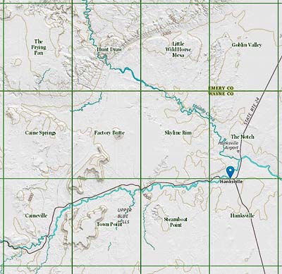
USGS 24K Topo Maps
The area south of Hanksville is covered by nine topo maps. These maps, together with a merged map, can be downloaded in a variety of formats by clicking or right-clicking below:
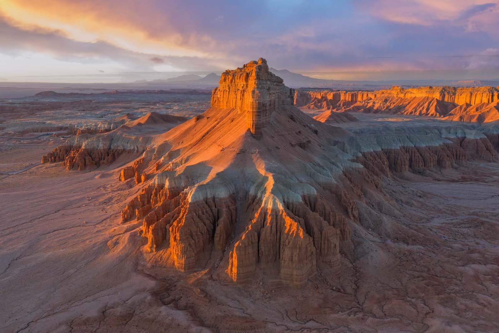
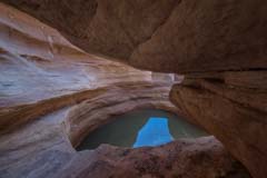
Arsenic Arch
Arsenic Arch
This small gem is rarely visited but can produce great photos when conditions are right. The dramatic skies of the summer work very well here. Arsenic is best shot at dusk. At dawn, it can take almost 90 minutes for the arch to receive full light, as there are cliffs to the east. The arch overlooks Poison Spring Canyon, and the Henry Mountains are visible to the west. Arsenic Arch is best photographed close up. In addition to the standard straight-on shot from the south, Arsenic also photographs well from the north and from its corners with a wide-angle lens. You can also shoot the arch from the canyon's rim at sunset with a 200 - 300 mm lens.
Arsenic Arch is only a few miles from Little Egypt (directions below). Little Egypt is best shot at dawn, so I suggest shooting Little Egypt at dawn, followed by Leprechaun Canyon at mid-day, and Arsenic Arch at dusk. Alternatively, shoot Arsenic first at dusk. Then, camp near the trailhead or at Little Egypt and visit Little Egypt at dawn. A good camping area with room for one or two cars is just up the hill from the Arsenic trailhead and is shown on the map below.
Arsenic Arch is about 26 miles from Hanksville by car. To get to the "trailhead," take US 95 south from Hanksville 20.4 miles. Turn left onto BLM 15210 (North Turkey Knob Road) and follow this good dirt road 5.1 miles to a one-car pullout on the left and park. Arsenic Arch is a trailless .75 miles from the pullout. It lies about 100 feet below the cliffs of Poison Spring Canyon. The hike is easy, provided you can find your way down the cliffs. Unless you are a rock climber, the only way down is at 38.102467, -110.541270. Once you have made the short descent, proceed NE and follow the cliff around the small side canyon to the arch.
Arsenic arch is on the 24K topo map Turkey Knob and can be downloaded above.
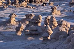
Little Egypt
Little Egypt
The Little Egypt Geological Area is one of my favorite locations. It is similar to Goblin Valley but much smaller and less crowded. I've been there four times at dawn and never seen anyone else. Little Egypt is magnificent at sunrise when the rocks take on a wonderful red glow. Little Egypt is much less impressive during the rest of the day and at sunset when cliffs to the west block the light. Goblin Valley has many more hoodoos than Little Egypt, and they are more easily isolated. Conversely, the background at Little Egypt is much more photogenic than Goblin Valley's, and some of Little Egypt's hoodoos feature white and red. To get to Little Egypt from Hanksville, take Highway 95 South 20.4 miles (milepost 20.2) from the intersection of Highway 24 and 95 in Hanksville. Turn right onto the good signed dirt road, go .25 miles, and turn left. Continue 1.2 miles to the signed "Little Egypt Geologic Area." Parking is about 100 yards down this road. The Google map Arsenic Arch above contains the directions as well.
Little Egypt is on the 24K topo map Raggy Canyon and can be downloaded above.
If you visit Little Egypt in mid-late October, you should continue south along Highway 95 and shoot North Creek, Hog Springs, or Leprechaun Canyon. North Creek runs southeast alongside Highway 95 and is lined with cottonwood trees. The creek is largely dry but usually contains reflecting pools. For the best color in the cottonwoods, shoot towards the sun. Control flare or shoot a sunburst by blocking the sun with a tree limb. There are also Cottonwoods at Hog Springs and a nice Cottonwood just before the first narrows of Leprechaun.
Leprechaun Canyon
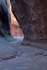
Leprechaun Canyon
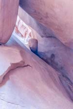
Inscription Chamber
Leprechaun Canyon is a real treat for the photographer with easy access and few crowds, especially on weekdays. Leprechaun is best known as one of the filming locations for the James Franco movie "127 Hours". Leprechaun is one of four "Irish Canyons" in the area, along with Lucky Charm, Shillelagh, and Blarney. I have not been into the last three, but I understand they require rappelling to access their best parts. Leprechaun parking is 28.1 miles south of the intersection of Highways 24 and 95 in Hanksville. After parking, proceed 0.5 miles and take the right fork. You'll soon reach a narrow but shallow slot; the trail bypasses it to the right. Shortly after, the trail widens into a very photogenic chamber before becoming a narrow and dark slot again. At the end of the narrows section, the slot forks. The left side of the fork is mostly impassable; there is a small opening on the right, with a heavily graffiti-ed "Inscription Chamber" just after it. If you would like to explore more of the Irish Canyons North Wash Outfitters leads guided rappelling tours into Leprechaun and Blarney Canyons.
Leprechaun Canyon is on the 24K topo map Turkey Knob, and can be downloaded above.
Northwest of Hanksville
This region is accessed via Utah State Route 24. Areas of interest include, from west to east, Caineville including North and South Caineville Mesa, Factory Butte, Skyline View, Long Dong Silver, The Mars Desert Research Station (MDRS) area, the Hanksville-Burpee Quarry, Little Wild Horse Canyon, and Goblin Valley.
Here is a map showing the locations of the above:
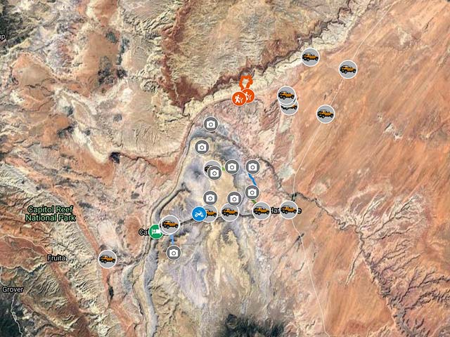
To view the map in Google Maps, please click anywhere on the map above.
- Click to download a KMZ file (Note - in IE, Right Click and choose Save Target as)
- Click to download a KML file (Note - in IE Right Click and choose Save Target as)
- Click to download a GPX file (Note - in IE, Right Click and choose Save Target as)
USGS 24K Topo Maps
This area is covered by twelve USGS topo maps. The maps, together with a merged map, can be downloaded in a variety of formats by clicking or right-clicking below:
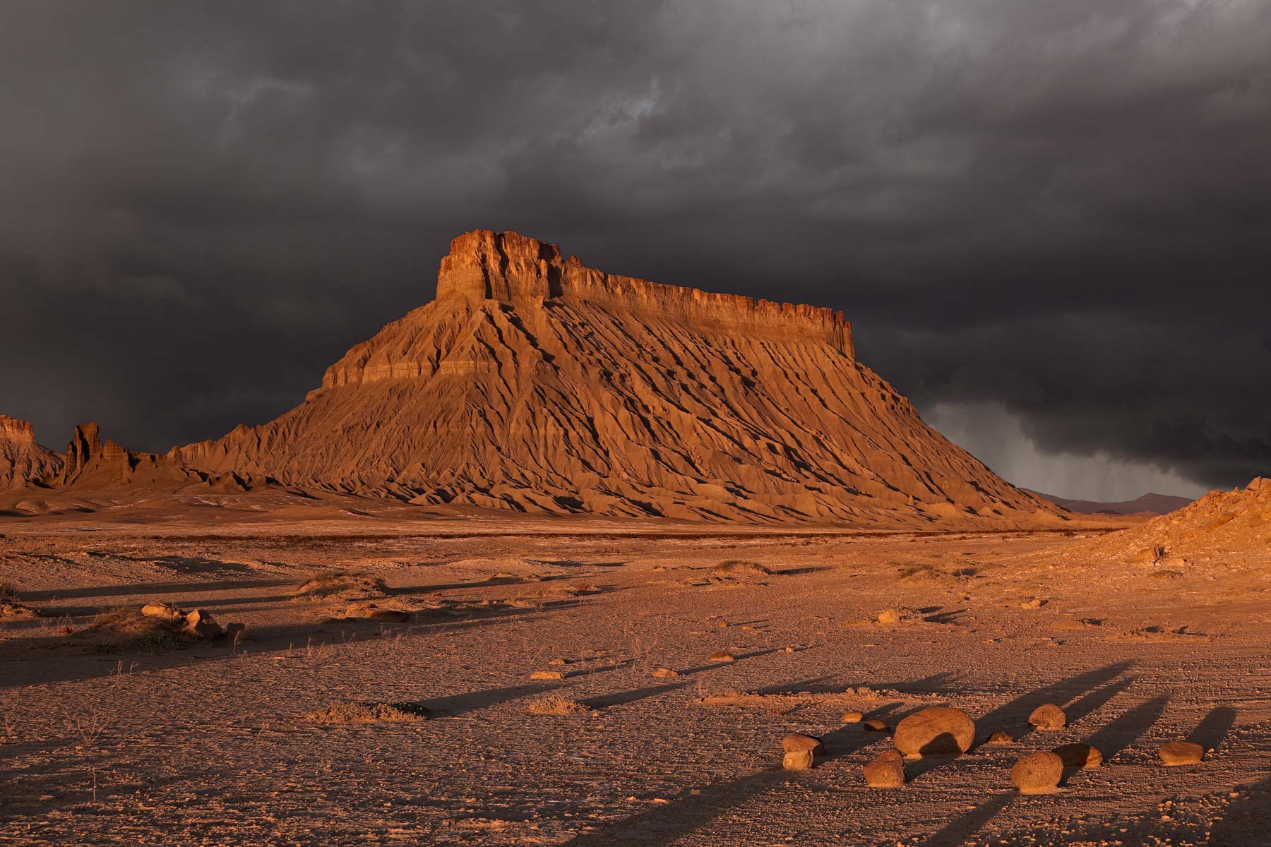
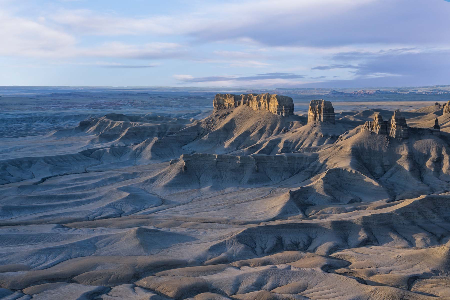
Factory Butte
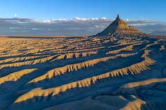
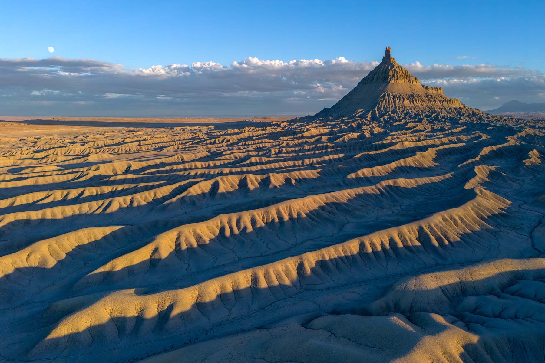
Factory Butte and Surrounding Badlands
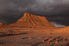
Factory Butte at Sunrise
The Factory Butte area is a captivating testament to the raw and diverse landscapes of the American West. Dominated by the striking, iconic Factory Butte, a massive, solitary formation rising from the desert floor, this region embodies a surreal, captivating beauty. It entices adventurers, photographers, and nature enthusiasts with its vast expanses of undulating badlands, sculpted mesas, and multicolored sandstone formations. The area's remote, untouched nature creates an immersive experience for those seeking solitude amid the unique, hauntingly beautiful desert scenery. Visitors are treated to a seemingly endless expanse of open spaces, offering opportunities for off-road exploration, ATV riding, and photography against a backdrop of stunning geological formations. As an off-the-beaten-path destination, the Factory Butte area embodies an untouched wilderness, inviting intrepid explorers to discover the captivating allure of Utah's remote desert landscapes.
Factory Butte is best viewed at sunrise. The butte is surrounded by a sea of Mancos Shale, which is interesting in itself, especially during wildflower season. The Mancos Shale is occasionally marred by ATV tracks, now allowed in the area. Factory Butte is best photographed at dawn from the east side or at dusk from W Factory Road. If shooting from W Factory Road, use a drone to include the magnificent badlands surrounding Factory Butte. Access to Factory Butte is via Factory Bench Road, a good gravel road (2WD is okay for much of it). The road is also known as Coal Mine Road or Muddy Creek Road. Factory Bench Road starts at Highway 24, 9.7 miles from Hanksville. A good location from which to photograph the butte is about 5.5 miles from the intersection of Highway 24 with Factory Bench Road. A small rock outcrop and some small round boulders provide a good foreground. You'll need to shoot at f/16 for DOF, or you could focus bracket. If you enjoy off-road adventures, Factory Butte Road splits near the mine on the topo map. The east fork connects to Wild Horse Road and Muddy Creek, and the west fork goes to the Salt Wash area and Caineville Road. Muddy Creek is well-named; many cars have been stuck in the mud there.
The Factory Butte area is best visited in late October, when the cottonwoods are changing color, or in mid to late May, when a carpet of wildflowers occasionally graces the badlands.
Boondocking is readily available along Factory Bench and Cow Dung Roads. During the warmer months, stay in a campground with electricity so you can run air conditioners. We recommend the Offroad RV Resort, which has full hookups and spacious sites at a reasonable rate. If you are not camping, Cathedral Valley Inn, just outside the east end of Capitol Reef, offers pleasant rooms at a reasonable rate. You'll need to travel to Hanksville for food or gas.

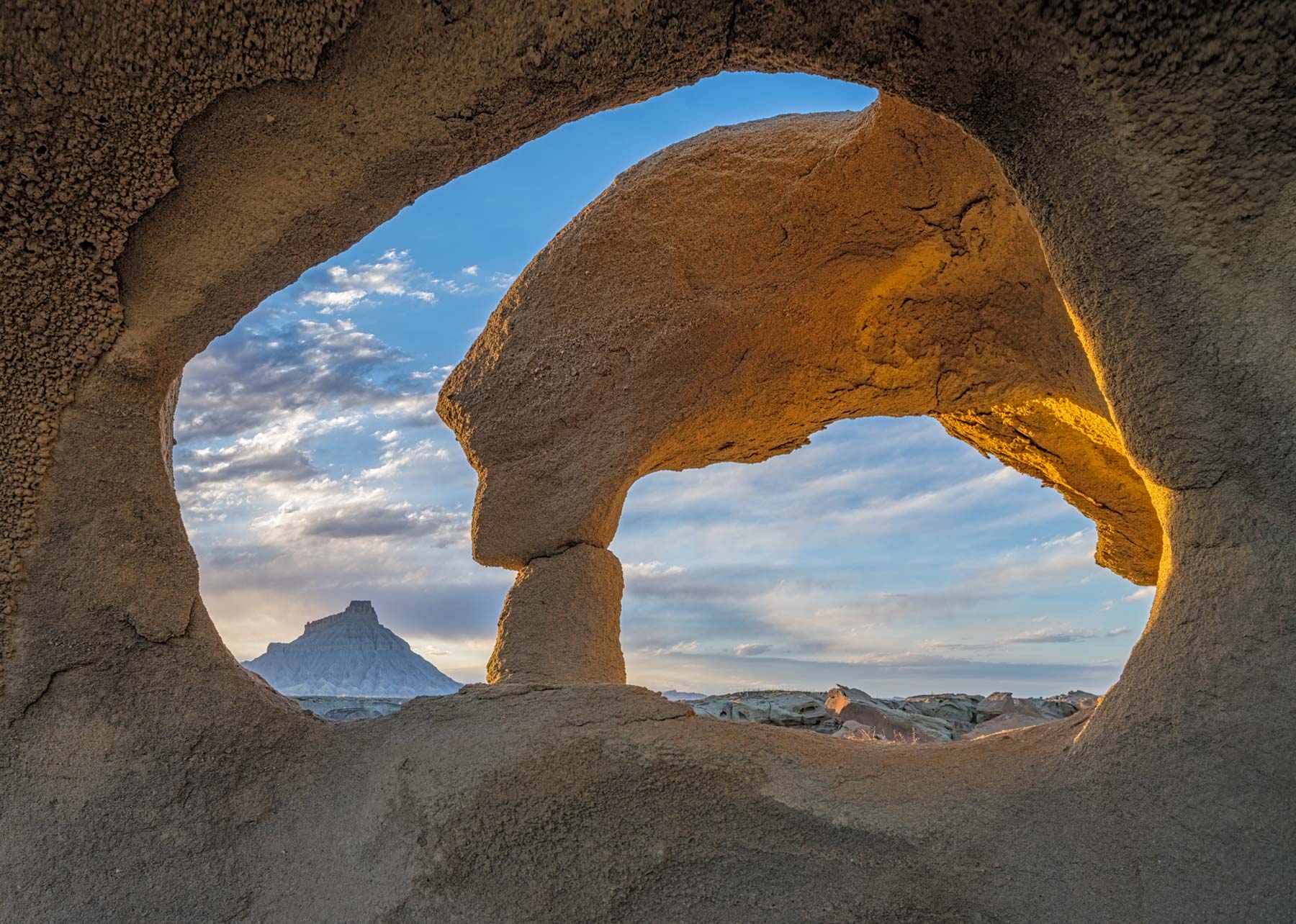
Arch framing Factory Butte
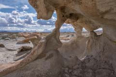
Triple Arch in the eroded badlands
Two groups of small arches frame Factory Butte. The first group is at 38.39539,-110.88971 and contains four arches, all of which frame Factory Butte. The arches are best photographed at sunset, when they take on a nice glow. To access the arches, drive 2.2 miles down Coal Mine Road and park along the side of the road. Hike off-trail 400 feet or so to the arches. You'll need a wide-angle lens for two of the arches; the wider, the better.
The second group of arches is near the old Factory Butte Coal Mine. The area contains dozens of tiny arches and other eroded rocks. The area reminds me of a cross between the fantastic shapes of Little Finland and the coloration of the Bisti Badlands, which is also in a coal mining area. To access the area, drive 9.7 miles down Coal Mine Road to the signed turnoff for the coal mines. The closed, sealed-off mines are no longer viewable. Turn right, drive 0.7 miles, and park. The eroded rocks and arches are about 50-100 yards to the west-northwest of the parking. You will almost certainly have the area to yourself.
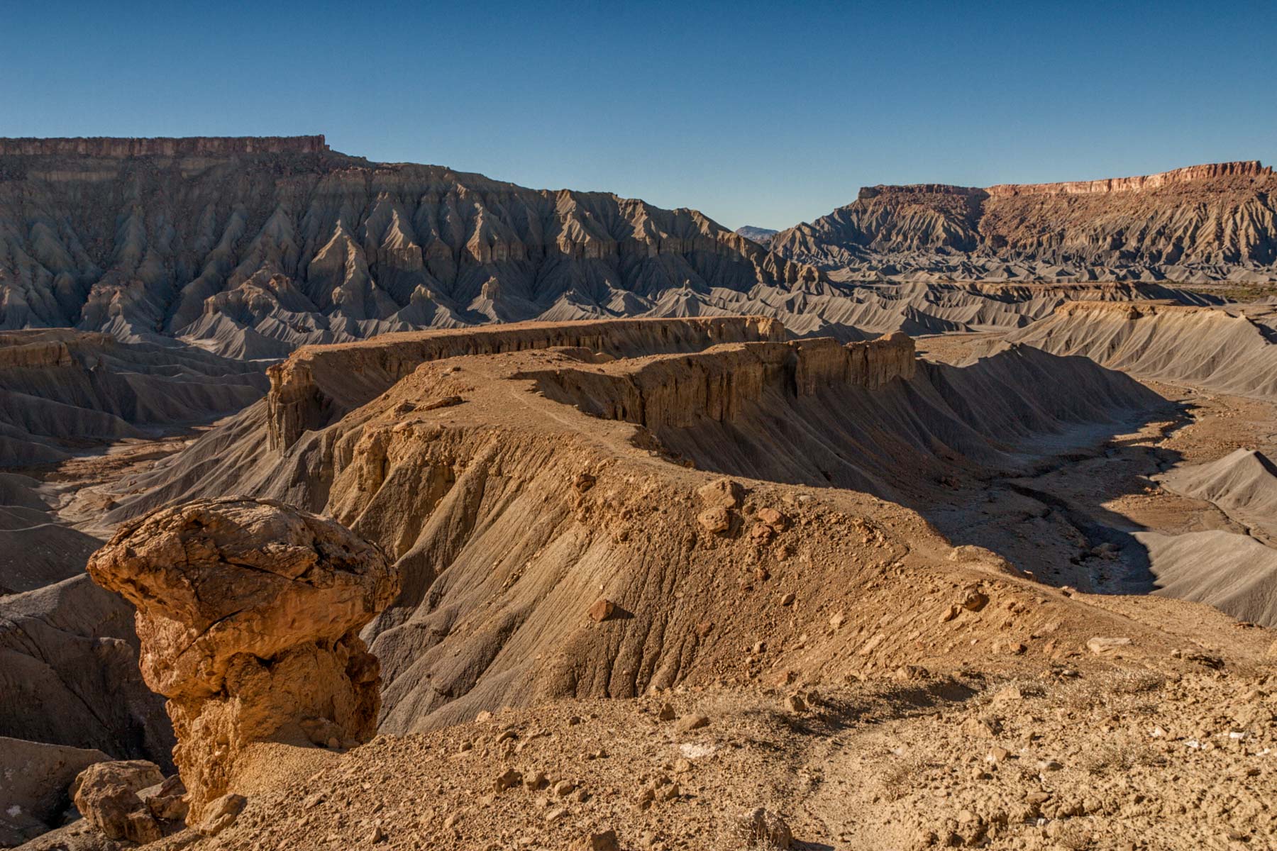
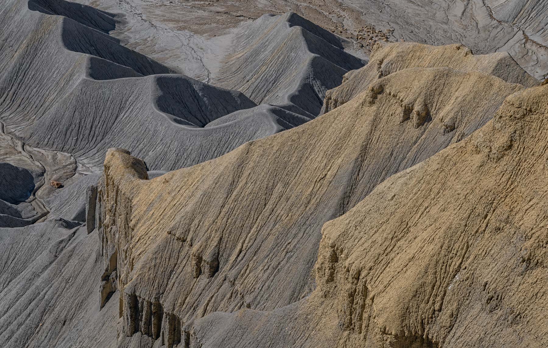
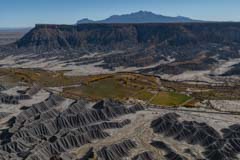
South Caineville Mesa

South Caineville Mesa
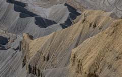
Mancos Shale Badlands
Closer to Caineville, there are good hikes through the Mancos Shale badlands to the summits of North and South Caineville Mesa. The South Caineville Mesa hike is harder, gaining 1,200 feet of elevation over 2.7 miles. The trailhead is just west of a small gully at milepost 100.2. When I last hiked this in 2005, there was no fence there. There is now a fence with a gate that may be locked (conflicting information). You must cross the Fremont River on this hike, and you will get wet. Towards the mesa top, the trail becomes difficult to follow. Spend the time to find it, as you need to be on the trail to climb the cliffs at the summit. Once you reach the summit, sign the register. The last time I was there was in 2005. There were very few entries in the register that year. After summiting, optionally, continue to the Steele sheepherder's cabin; this adds another 1.4 miles one-way to the hike. The sheepherder's cabin is quite photogenic and well preserved.
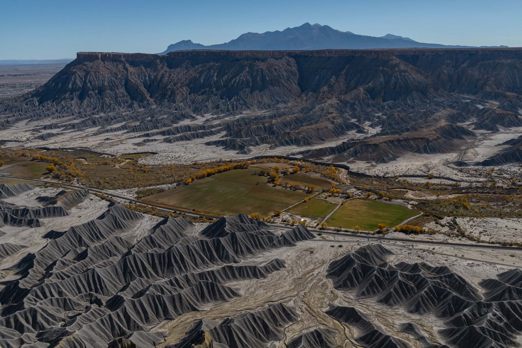
North Caineville Mesa
North Caineville Mesa
North Caineville Mesa captivates with its rugged beauty and sheer magnitude. The panoramic views from atop the mesa offer a breathtaking spectacle, with the vast expanse of the surrounding desert stretching out to the south. The North Caineville Mesa hike is shorter but steeper than the South Caineville Mesa hike, gaining 1,200 feet of elevation over only 0.9 miles. This enjoyable hike has great views of the badlands to the mesa top, and you will almost certainly have the trail to yourself. The trailhead is at the old yellow cement mixer 2.1 miles east of the Rodeway Inn in Caineville. There is a good video of the hike at this link. It's not a hike for the faint of heart. Close to the summit is a small hole in the rock you must squeeze through to access the top. Do not try to bypass it to the left; a fall here would be fatal. The views from the summit are magnificent.
Skyline View

Skyline View at Dawn
East of Factory Butte, there is a great viewpoint on Skyline Rim. Skyline View is also known as Moonscape Overlook. I think Mars Overlook might be a better name since the Mars Desert Research Station is just three miles southeast. To get to Skyline View Overlook, take Coal Mine Road 6.1 miles and turn right. Continue 2.7 miles to the rim. The best light is at sunrise. For sunset shots, arrive early, or there will be no light on the badlands below the rim. Skyline View may be good at night, also when the moon is out and to the east. Overnight camping is allowed close to the viewpoint.
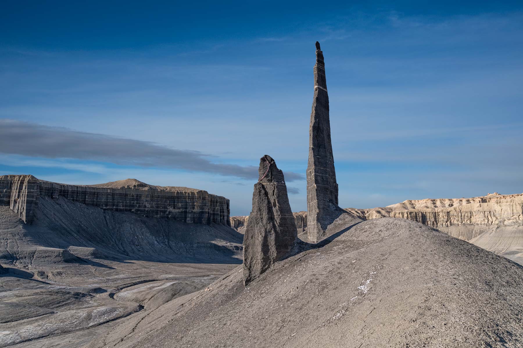
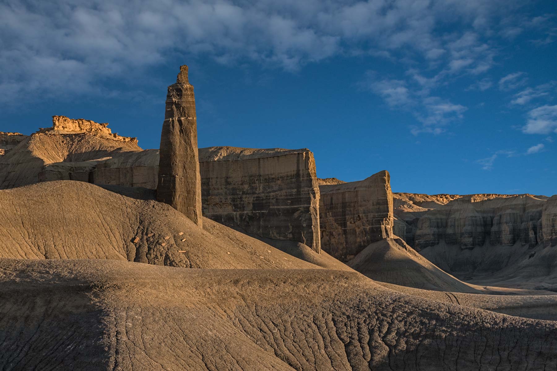
Long Dong Silver
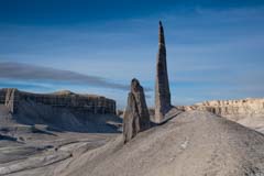
Long Dong Silver
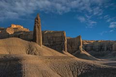
Unnamed tower
Further east is a very tall hoodoo cleverly named "Long Dong Silver" by rock climbers. Long Dong Silver is also known as "The Spire". Some protection had been left at the top of the rock when I was there. I chose to leave it in my pictures. You may want to clone it out. To get to Long Dong Silver from Coal Mine Road, drive 3.1 miles east on Highway 24 and park on the side of the road. Hike 1.8 miles north up the wash to the hoodoo. The best light is close to sunrise, though sunset will work as well. On the way to Long Dong Silver, you will pass another rock tower to the left which is also photogenic and worth shooting. The best light on this tower is at sunrise; sunset will not work. Drones are allowed at Long Dong Silver. It is also possible to shoot Long Dong Silver from Skyline Rim; the map below shows my track. The off-trail hike is 1.4 miles one way.
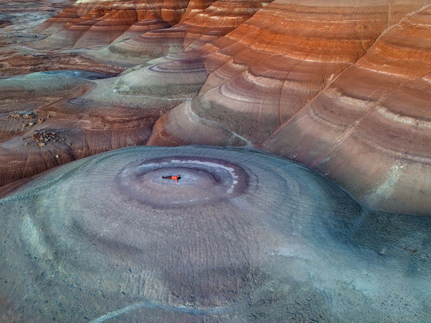
Cow Dung Road, the MDRS, and the New Bentonite Hills
The New Bentonite Hills

Nipple Hills
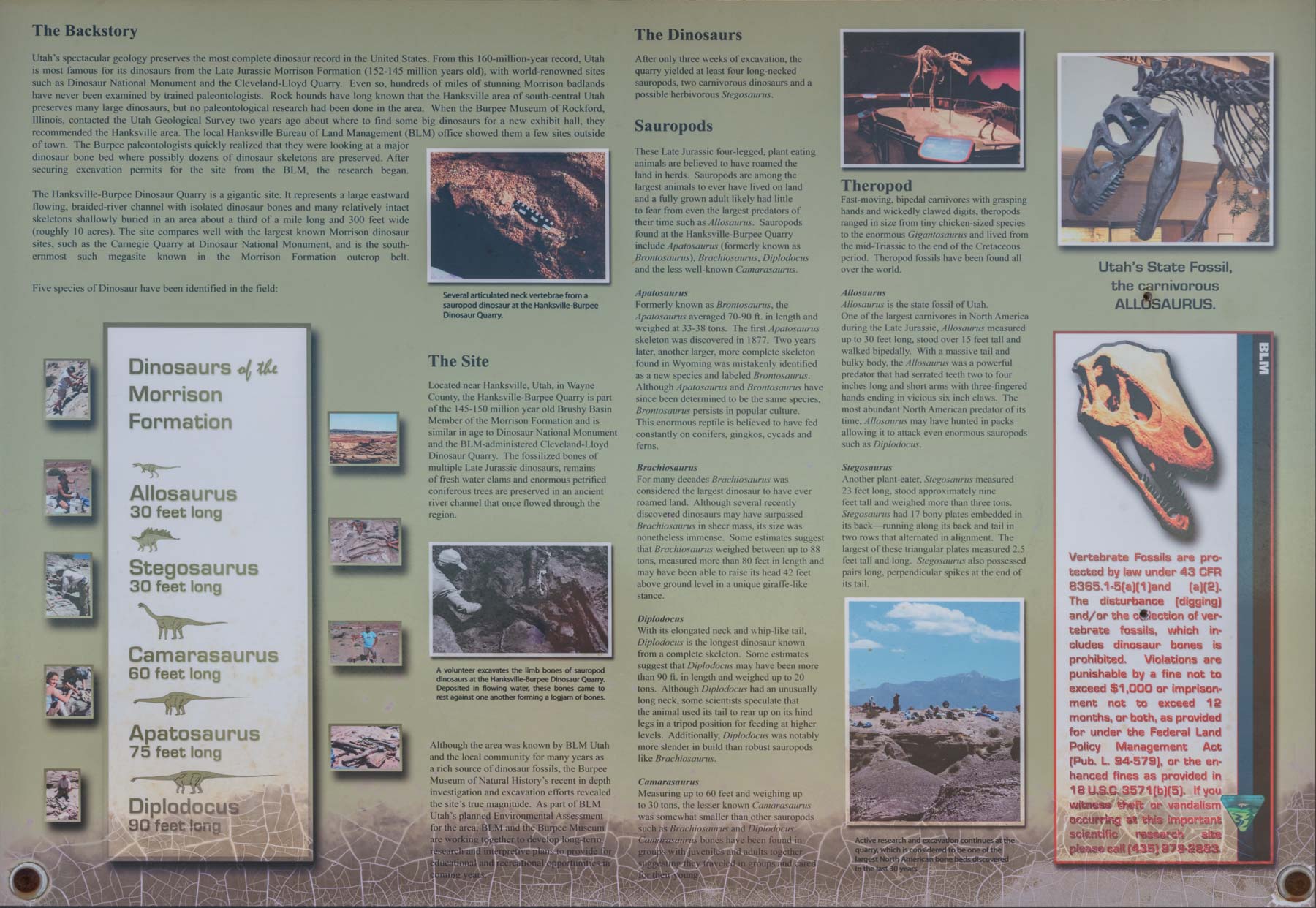
Still further east you can explore the area around the MARS Desert Research Station (MDRS). The red and white badlands in the area are quite photogenic. The area around the New Bentonite Hills is especially so. The hills are best shot with a drone. Include a person for scale. Expect to see the Instagram crowd flying drones at both sunrise and sunset. Most of the images I've seen on the web are very blue. The lighter rocks seemed more gray or white than blue when I was there. I developed my photos accordingly. Access to the New Bentonite Hills and the MDRS is via Cow Dung Road, 3.8 miles west of the intersection of Utah 24 and 95 in Hanksville. From the intersection, continue for 4 miles and park on either side of the road. The New Bentonite Hills are 0.15 miles to the west. Further out, Cow Dung Road leads to more abstract badlands. Park near the wash at 38.43204, -110.79197, and launch your drone from one of the hills to the north. Two of the eroded hills to the northwest have a nipple like appearance. These badlands are not quite as photogenic as those at the New Bentonite Hills, but they are crowd-free. Even further north at the end of Cow Dung Road is the Hanksville-Burpee Dinosaur Quarry where many dinosaur bones have been found. These include fossils of Stegosaurus, Brontosaurus, and Apatosaurus. The Burpee Museum is responsible for excavating the site and conducting tours with the BLM each summer. For more specific directions and information, stop by the BLM-Utah field station at 380 South 100 West in Hanksville, Utah, or call (435) 542-3461.
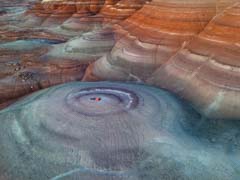
The Painted Hills

The Painted Hills near BLM 0157

The Painted Hills near BLM 1573
At the end of Cow Dung Road to the west lie the Painted Hills. The extensive badlands in this area are spectacular and little explored/known. You'll need a drone to get good pictures of the area. I suggest you climb up one of the buttes and fly from there. Otherwise, you may lose signal. The area contains a huge number of fossilized oyster shells. There are so many that, at one point, they were used to pave roads. The BLM allows you to collect a small number of them: "You may collect reasonable quantities of common invertebrate fossils such as mollusks and trilobites, but this must be for personal use, and the fossils may not be bartered or sold." The fossils are of late Cretaceous age, about 80-85 million years old. The Painted Hills are difficult to access. You'll need a high clearance 4x4, preferably with a short wheelbase. To access the hills, take BLM 1574 until it becomes BLM-0157. This is a rough road seldom travelled. Do not drive in this area after a recent rain or if rain is in the forecast. There is a narrow, steep hill 0.4 miles in. When I was last there, the road was partly washed out, so I "rebuilt" some of it. If you're uncomfortable driving down the hill, park near 38.44358, -110.81367, and hike from there. The road continues down the canyon; you'll need to climb up onto one of the buttes to fly your drone. A good place to launch from is at 38.45312, -110.80876. The first image shows an image taken near there.
Continuing 0.6 miles down BLM 0157 brings you to a wide open space with a road (BLM 1573) coming in from the left. I only found occasional traces of the road, so I hiked northwest from there. The badlands here are spectacular. I launched my drone from the top of the hill at 38.46727, -110.81511. The flat ground at 38.46517, -110.80759 should also work. The second image was shot just north of there.
Little Wild Horse Canyon
Little Wild Horse Canyon
Little Wild Horse Canyon is a popular slot canyon east of Goblin Valley. I suggest you visit it on weekdays to avoid weekend crowds. To get to Little Wild Horse Canyon from Hanksville, drive northeast on UT-24 for 19.6 miles and turn left onto Temple Mountain Road. Take Temple Mountain Road 5.2 miles and turn left onto Goblin Valley Road. Drive 6.1 miles on Goblin Valley Road. Just before the fee booths for Goblin Valley, turn right onto Wild Horse Road and drive 5.4 miles to the parking area on the right. Little Wild Horse has two water pools right at its mouth; the trail bypasses them to the left. Shortly after the bypass trail ends, you will come to a fork; take the right arm, Little Wild Horse Canyon. The left fork is Bell Canyon. Further up the canyon, there are usually more pools. When we went, they were largely dry. Little Wild Horse can be combined with Bell Canyon for an eight-mile loop hike. You can do the loop in either direction; I recommend starting with Little Wild Horse so you can turn around early in the hike if there are water pools you would rather not cross. Little Wild Horse Canyon is in the Muddy Creek Wilderness Area, so drones are not allowed.
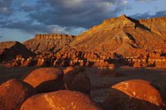
Goblin Valley
Goblin Valley
Goblin Valley State Park is a large state park with many brown-red hoodoos. The park was originally 3,654 acres. In 2022, over 6,300 acres of federal land were transferred to the park, bringing its current size to 9,915 acres. The park beckons photographers with its otherworldly landscape, a surreal playground of whimsically shaped sandstone hoodoos and rock formations. Admission to the park as of 2023 is $20 per car. RV camping is available for $45 per car. The fee includes the park fee, showers, and a dump station. There are no electrical hookups. Despite its remote location, Goblin Valley attracts many visitors on weekends and when the kids are off. If you visit, go mid-week unless you want to use "Content Aware Delete" in Photoshop a lot. Goblin Valley can be reached from the north by taking I-70 to exit 147, then going south on Utah 24. After 30 miles, turn right on the signed Temple Junction/Goblin Valley Road. Take Temple Mountain Road for five miles and turn left onto Goblin Valley Road to reach the Park entrance. From the south, the turnoff to Goblin Valley is 11 miles North of Hanksville. There are several official trails in Goblin Valley, but I suggest you wander among its hoodoos yourself. The parking area sits above the Valley, and a good observation point is right at the lot. The observation point faces south, and you can take good pictures at sunrise and sunset. Mount Ellen can be seen off to the west and provides a good background at dusk and dawn.

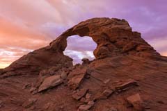
The Three Sisters

Wild Horse Window
While at Goblin Valley, be sure to visit The Three Sisters rock formation and Wild Horse Window, shown to the left. Shooting The Three Sisters is straightforward; the hoodoos run north-south and are good at sunrise and sunset. Shooting Wild Horse Window, also known as the Eye of Sinbad, is more difficult. Wild Horse Window is a pothole-type arch. This means that eons ago, water collected in a depression and eventually eroded the rock below it, joining it to an existing alcove or depression in a cliff face. Wild Horse Window is on the roof of the alcove and has a span of 35 feet. If you shoot from inside the alcove, Wild Horse Window seems to be a double arch. To capture both openings, you will need an ultra-wide lens or a panorama rig. Depending on the light, you might want to shoot the alcove from outside in as well. While there, view the pictographs on the right wall; apparently, they are "Fake Art" and were drawn in the early 2000s. Wild Horse Window can be crowded. It opens to the south, and the alcove frames the Milky Way nicely at night. The hike to Wild Horse Winow is about 2 miles round-trip with 400 feet of gross elevation gain. If you plan to go in at night or for sunrise hike, scout the route the day before. Establish the route and record it. The trail, while cairned, is over slickrock, and you'll need to locate the cairns to stay on track.

Wild Horse Butte at Sunrise
Drone use is by permit only. Same-day Permits may be obtained at the visitor center for a fee of $15.00. You may also pick up your permit the day before if you plan to fly in the early morning. I recommend you get your permit the day before you wish to fly. Shoot Wild Horse Butte at sunrise the next day. It's spectacular. Permit blackouts may occur during special events, emergencies, and periods of especially high visitation. You may also download and print the Utah State Park Drone Application and bring it with you for faster service. Within the Goblin Valley Fee Area, you can only fly your drone over Valley 1, outlined in the map below. Between March 1 and October 31, you can only fly on weekdays. Only ten permits are issued per day. More information about Goblin Valley drone regulations can be found on the Goblin Valley State Park website. Be sure to shoot Wild Horse Butte while there.
Northeast of Hanksville
Colonnade Arch

Colonnade Arch and Green River Bends
Colonnade Arch, also known as Five Hole Arch, is a spectacular but little-known arch with five openings near the Green River. Unfortunately, it is nearly 40 miles down a dirt road and is best shot at sunrise. The 4WD road to the arch is fair to good but is impassable when wet. After parking, you must hike off-trail about one mile to the arch. A GPS will be very helpful with this. The arch is below the rim; the easiest way down to the arch is from its south side. There are some cairns, but they are intermittent, and I was unable to follow them. There is a small but unique rock formation known as the Dragon's Teeth on the hike to the arch; coordinates are on the map below. Must see!
Colonnade arch faces east, so it has good light in the early morning. In the Spring, Fall, and Winter, you should be able to catch a sunburst at dawn. A wide-angle lens or panorama head is needed to capture the entire formation. Be sure to bracket; the light level inside the alcove is much lower than that outside. Given the long drive to the arch, you might want to combine it with a trip to overlooks of Trin Alcove Bend, Junes Bottom, or Ten Mile Bottom.
Overlooks of Labyrinth Canyon and the Green River

Aerial of Trin Alcove Bend
Trin Alcove Bend is a scenic and popular stopping point on the Green River at River Mile 90, deep in the Labyrinth Canyon Wilderness of Utah. John Wesley Powell named it for its alcoves and three canyon legs that branch from the main bend. The alcove and canyon legs are primarily accessed by self-supported canoe, kayak, or raft trips down the flat-water section of the river. They can also be reached by vehicle via rough 4WD roads to rim overlooks. I’ve shown the 40-mile 4x4 route to the rim above Trin Alcove Bend below. The road becomes very rough for the last few hundred yards. You may want to walk this section. You’ll need a drone to get the best pictures from the rim. The road lies outside the Labyrinth Canyon Wilderness Area, where drone launch and operation are permitted. Drones cannot be launched or operated within a wilderness area, but you can fly over it.
There are several other photogenic bends in the Green River nearby. The first is an overlook of Junes Bottom; the route is shown below. From the overlook, you can hike to the river via an old wagon trail. There are cabin ruins and some artifacts along the way. The west bank of the Green River is in the Labyrinth Canyon wilderness, so no drones are allowed except as shown on the map. Downstream from Junes Bottom, the Green River has more bends. I suggest driving out to the overlook of Ten Mile Bottom. There are three photogenic bends there, and you can tent camp or camp in your car. A drone is recommended for the best shots.
To view the map in Google Maps, please click anywhere on the map above.
- Click to download a KMZ file (Note - in IE, Right Click and choose Save Target as)
- Click to download a KML file (Note - in IE Right Click and choose Save Target as)
- Click to download a GPX file (Note - in IE Right Click and choose Save Target as)
Colonnade arch is on the 24K topo map Bowknot Bend. Click or Right-click below to download the map.
| Geo Tiff/Avenza | KMZ | Oruxmaps | KMZ Decollared | Oruxmap Decollared | Avenza Decollared |
| Bowknot Bend | KMZ | Oruxmap | KMZ Decollared | Oruxmap Decollared | Avenza Decollared |
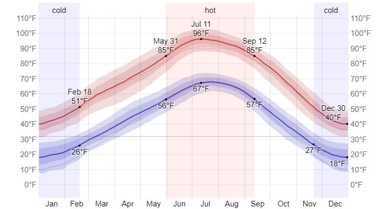
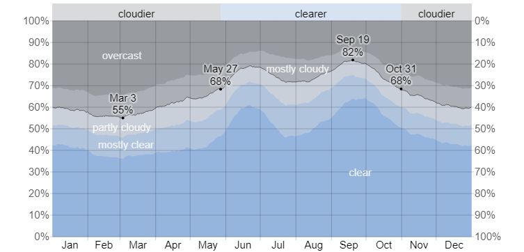
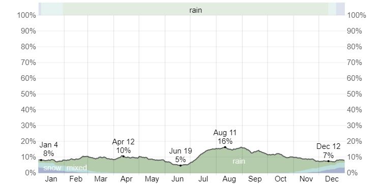
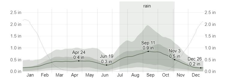
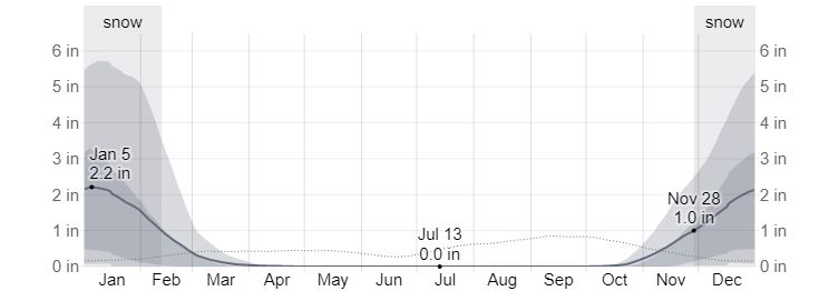
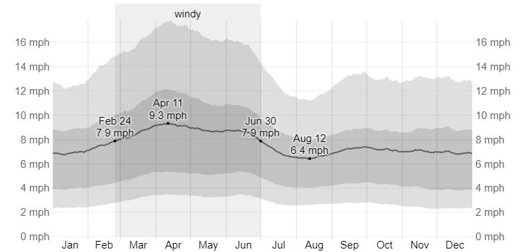
Climate
The following graphs are from weatherspark.com.