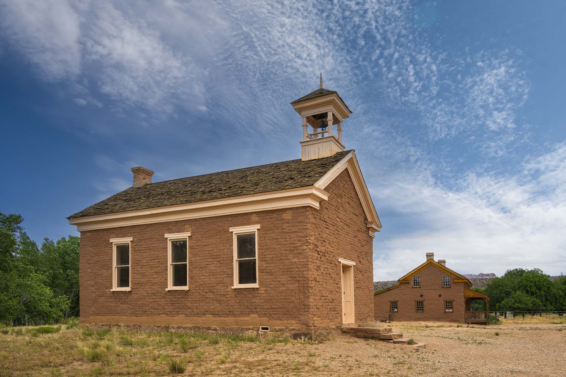
Grafton Ghost Town
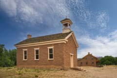
Grafton Church

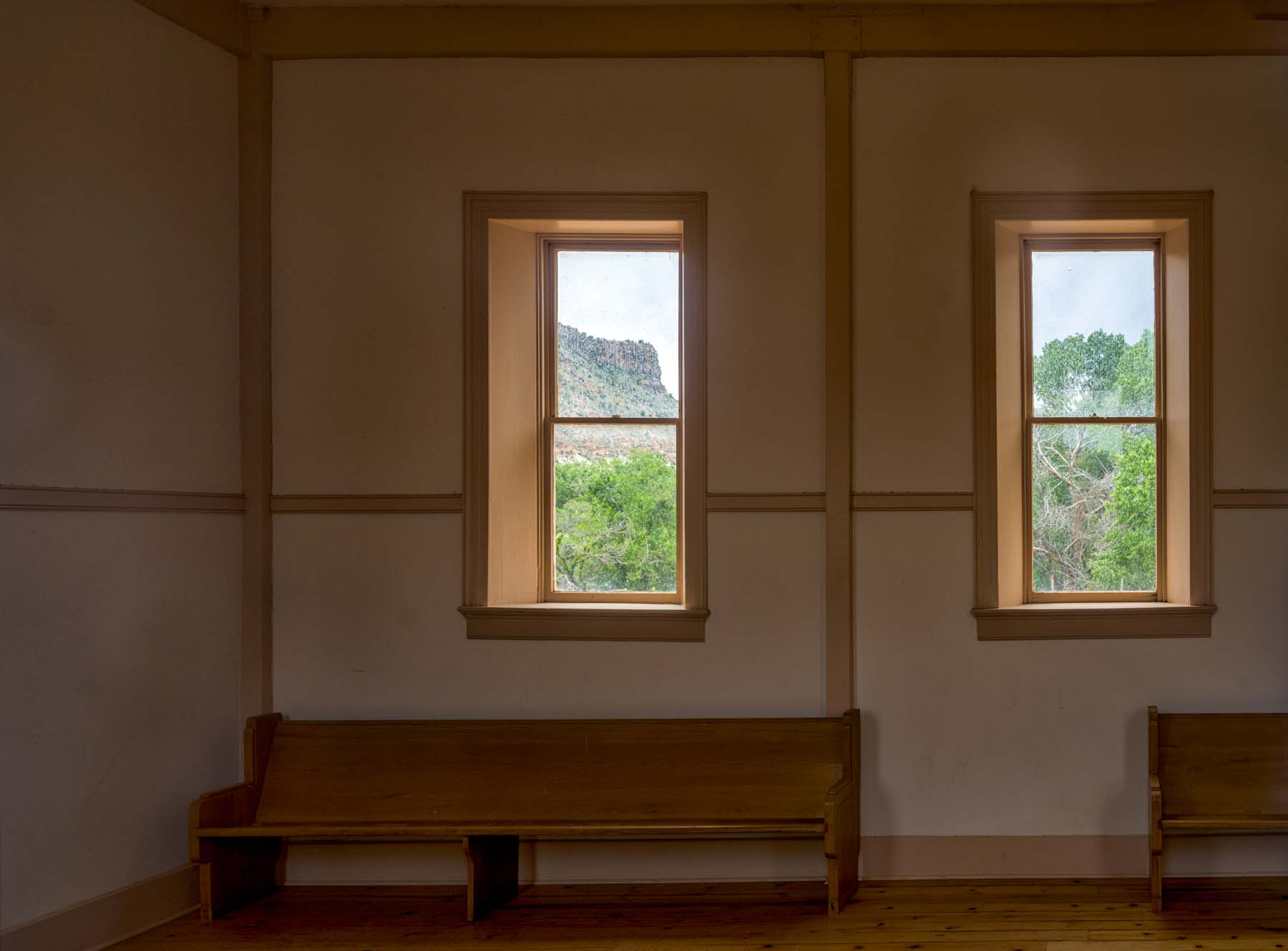
Grafton Church Interior
Grafton is an abandoned Mormon town about seven miles west of Springdale, Utah. It is worth a quick visit if you are visiting or passing through Zion National Park. Grafton was settled in 1862 and abandoned due to flooding in the early 1920s. The six remaining buildings in Grafton are not furnished. You could enter three of the buildings when I was there. The church/schoolhouse is normally closed. The Grafton Cemetery is about .25 miles south of the town.
Several movies have been shot in Grafton, including parts of Butch Cassidy and the Sundance Kid. Butch, Sundance, and Etta sought refuge in Grafton, and the bicycle scene with Paul Newman and Katherine Ross was filmed in Grafton. The movie In Old Arizona, the first talkie filmed entirely outdoors, was also shot in Grafton. The film, released in 1929, advertised its authentic settings and the natural sounds of the outdoors. Star Warner Baxter won the second-ever Oscar for Best Actor for his portrayal of The Cisco Kid. The movie is available on amazon.com, and enters the public domain in 2024.
Grafton is free and open 24 hours a day.
Weather and Climate
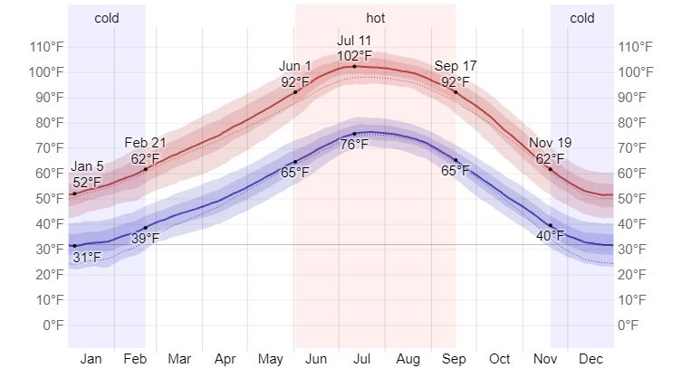
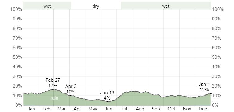
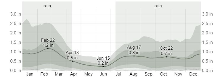
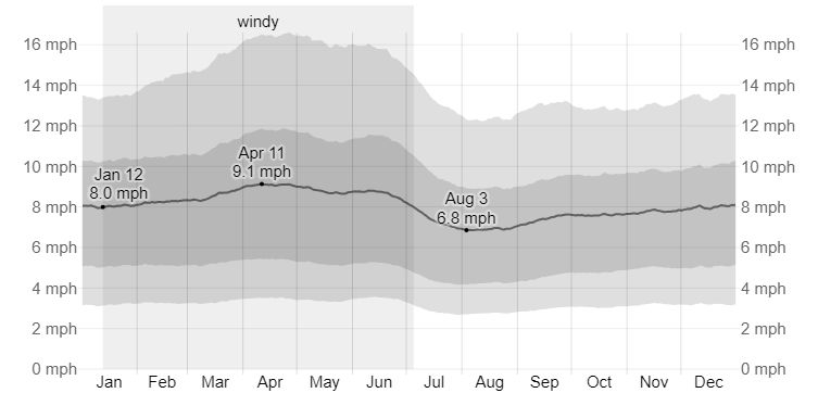
Saint George, Utah, is the closest town to Grafton with available climate data. The elevation of Saint George is close to that of Grafton, so temperature differences are minimal. The following graphs are from weatherspark.com. In addition to the data shown here, Weatherspark also includes data on wind direction. Winds generally come from the northeast in winter and the southwest in the summer.

Current weather and forecasts are available at the following sources:
- Weather Underground - Springdale, Utah
- Accuweather - Springdale, Utah
- Weather.com - Springdale, Utah
- NWS - Grafton Point Forecast
Based on the above, Spring and Fall are the best times of the year to visit Grafton. They offer moderate temperatures and little chance of rain. Despite the heat, summer visits are okay since no hiking is involved. Winter afternoons in Grafton often reach 50°F and can be comfortable.
Maps and Directions
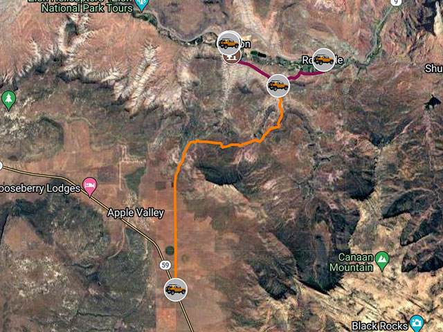
The closest town to Grafton is Rockville, about three miles away. Rockville is six miles or 14 minutes from the south entrance to Zion National Park. To get to Grafton from Main Street (Route 9 in Rockville) turn onto Bridge Road After .3 miles turn right onto 250 S/Grafton Road and continue 3.1 miles on the gravel road. There is no formal parking for Grafton so park on 250 S near its entrance. Grafton Road is impassable when wet. Do not drive it after a rain.
If you're up for an adventure and coming from the south Grafton can be accessed from the south via the 4x4 S Bench and Smithsonian Butte Roads. Smithsonian Butte Rd is rather rough.
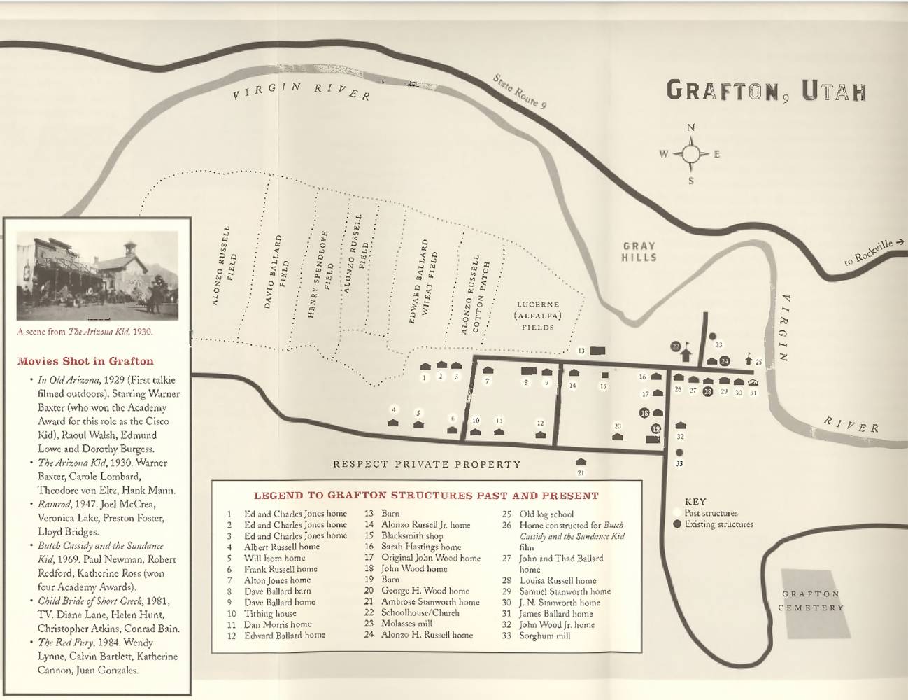
The Grafton Heritage Partnership Project publishes a brochure containing a map of the buildings in Grafton and the story of its settlement. The brochure needs updating as there is a new building in Grafton. The map shows an empty lot at site 16 owned by Sarah and William Hastings. The Hastings had eight children and lived in a largely underground dugout with a wooden front, door, and two windows. They moved to Grafton in 1981. William died in 1882, and the tough Sarah lived in the dugout for over 50 years, moving to Hurricane in 1915. She died at the age of 90 in 1920. The dugout is no more. In 1947, a cabin was moved from Beaver, Utah to site 16. The cabin was used as the home of the character Rose in the western "Ramrod". The cabin was restored in 2020 and was named the Ruby Rose cabin after the character in the movie. Stories like this are why I love visiting ghost towns.
The Google map below contains driving directions and locations of the remaining structures in Grafton.
To enlarge the map and view it in Google Maps please click anywhere on the map above.
Google Maps have two sections. The left side of the map typically shows a legend. If the legend is hidden, click the "Map Legend" box on the upper left to reveal it. The legend includes a list of folders. To display or hide the contents of a folder, click the check box to its left. Folders contain locations and routes. Click on a place to display more information and possibly a cropped photo. Click on the cropped image to display a higher-resolution uncropped version. The legend's top right shows a magnifying glass icon and three dots (ellipsis). Clicking on the magnifying glass brings up a search box to find a particular location or route. The ellipsis gives you several options. You can collapse the legend so you can see more of the map, print the map, download a KML file for use with a GPS, or view the map in an online version of Google Earth.
The right side shows the map. To drag the map, hold the left mouse button down. To zoom in or out, use the mouse wheel or the +- box on the lower left. Clicking on a route or location brings up its details.
The online version of Google Earth helps measure distances and display GPS coordinates, elevations, and additional photos of the area. To measure distances, click the ruler icon at the bottom left. GPS coordinates and elevations at the cursor are displayed on the bottom right. Click the menu icon (three bars) on the upper right and drag the Photos slider to the right to reveal additional images.
- Click to download a KMZ file (Note - in IE Right Click and choose Save Target as)
- Click to download a KML file (Note - KML files do not include custom icons)
- Click to download a GPX file (Note - in IE Right Click and choose Save Target as)