Devils Tower National Monument
Introduction
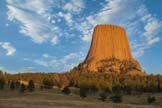
Devils Tower is a butte in northeast Wyoming high above the Belle Fourche River. It is perhaps best known as the site of the climatic scenes in Spielberg's movie "Close Encounters of the Third Kind". Devils Tower is 1,267 feet above the nearby Belle Fourche River, and 867 feet above its base. Devils Tower is the first US National Monument and was created in 1906 by President Theodore Roosevelt. Devils Tower is in a somewhat remote area of the country. Within two to three hours of driving are the Black Hills, Custer State Park, Badlands NP, Mount Rushmore, and Wind Cave NP. Yellowstone is seven hours away.
Official Park Map
Below is the official Devils Tower National Monument map as a jpeg and in four geocoded formats: GeoPDF, GeoTiff, KMZ file, and Oruxmaps.

- Click to download a high resolution Jpeg file. File is not geocoded.
- Click to download a GeoPDF file.
- Click to download a GeoTiff file viewable in PDF Maps.
- Click to download a KMZ file viewable in Google Earth.
- Click to download an Oruxmap file (Note - in IE Right Click and choose Save Target as).
When to Go
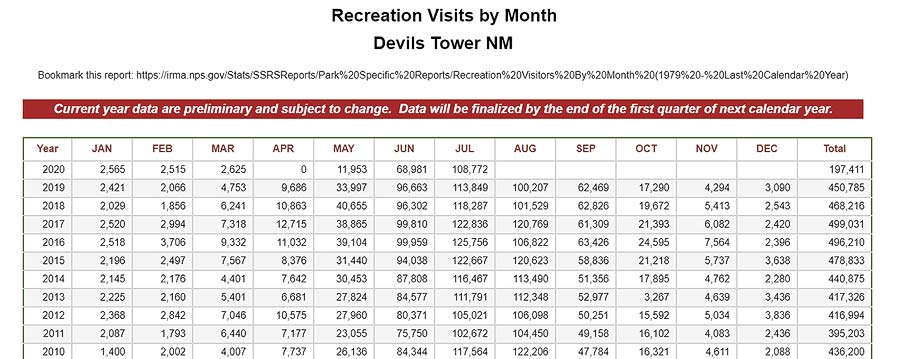
Devils Tower is open every day of the year. In late September the aspens at Devils Tower change color, and around mid October the cottonwoods at the Belle Fourche campground change making this the perfect time to visit. June through August can be crowded. During the summer arrive at the entrance station early or expect to spend 30 minutes or more in the line at the gate. The National Park Service maintains visitor statistics for Devils Tower.
Lodging and Campgrounds
The Belle Fourche River campground is closed from November through April, and is currently (2020) closed due to Covid-19. It has 46 sites and handles RVs up to 35 feet. There are no Hookups but potable water is available. No reservations; strictly first come/first served. In the summer on weekends the campground may fill up, but theres a good chance on weekdays the campground won't fill. There is decent cell service from Verizon and AT&T. A KOA campground with full hookups is just outside the entrance gate.
If you would rather not camp Devils Tower Lodge is just outside the park and well regarded. The lodge is normally open from May 1 through September 30. It has only six rooms so I suggest you book early.
Devils Tower Climate (°F)
Devils Tower climate is that of a a typical high desert in the northern part of the US. Winters are very cold with lows around 15°F and highs around 32°F and understandably there is little visitation. Winter is also the cloudiest part of the year with cloudy or mostly cloudy days 50% of the time. Despite the clouds winters are relatively dry with monthly snowfall normally between one and two inches. Spring is milder with overnight lows in May around 40°F and highs around 60°F. Cloud cover is similar to winter. Snow in April is not uncommon. Summers are warm with highs in the high 70s to low 80s and lows in the low to mid 50s. Summer brings clear to mostly cloudy skies 75% of the time. September and October bring cool weather with clear or partly cloudy days about 60% of the time. Historical temperature, cloud cover, and rainfall data for the town of Sundance, Wyoming (about 20 miles from Devils Tower) can be found on weatherspark.com.
Photography

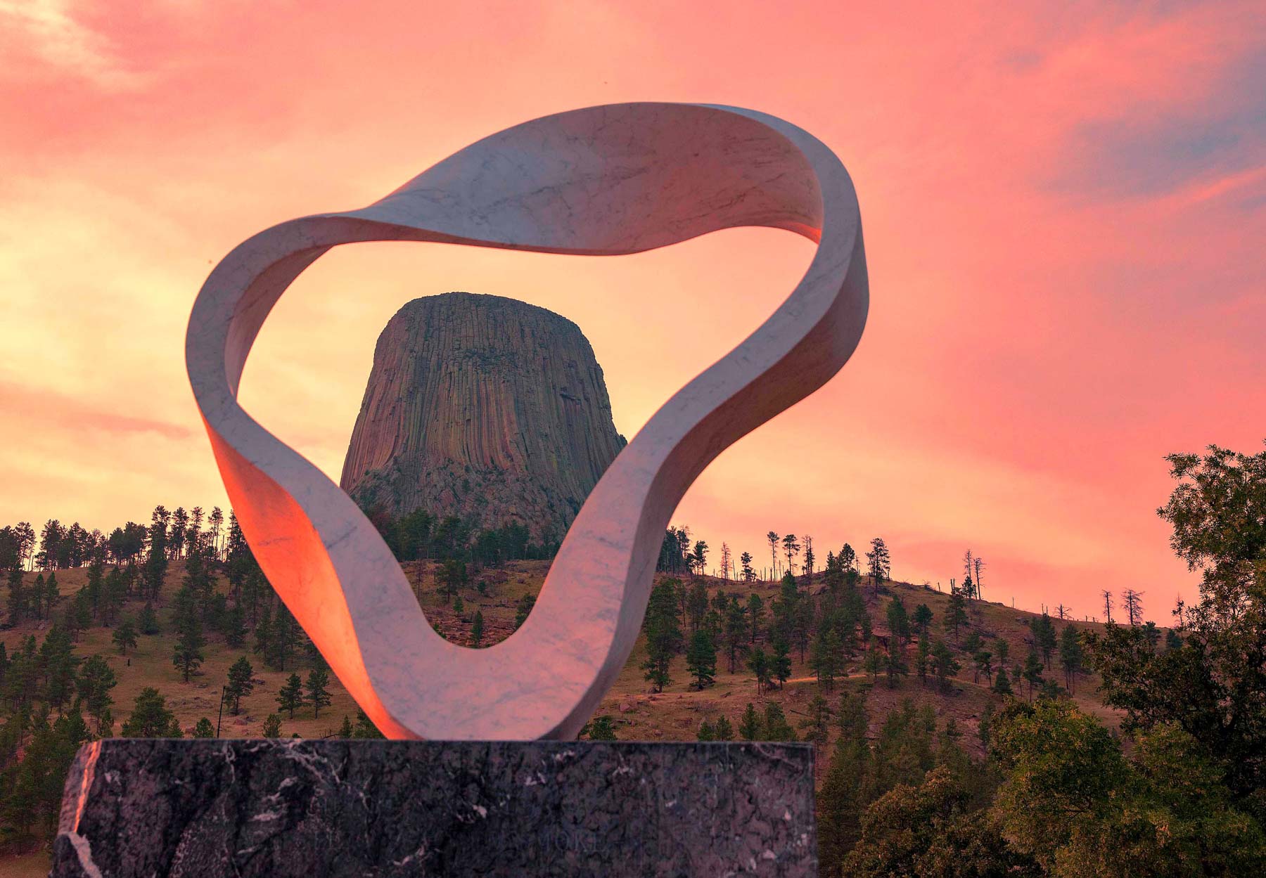
Circle of Sacred Smoke
Devils Tower from W Road Trailhead
Devils Tower is yellow and gray in color and does not photograph well mid-day. At sunrise and sunset it takes on a warm orange color and is spectacular. There are several good photo opportunities in or near the park.
If arriving from the south, as most visitors do, you will come to a series of viewpoints along Highway 24. These present unobstructed view of the tower and are best at sunrise. Texas longhorns and buffalo graze the fields to the left of 24 and make excellent foreground when present. Another good sunrise viewpoint is from the Belle Fourche River Campground. Reflections of Devils Tower in the river occur at several spots, I have shown one spot on the map below. If you are there in late September to mid October try to include cottonwoods in your image as well.
A sculpture know as The Wind Circle, or the Sacred Circle of Smoke, is only two hundred yards from the Belle Fourche River campground and should definitely be seen. The sculpture, made of carrara marble, was created by internationally renowned Japanese artist Junkyu Muto. It frames Devils Tower perfectly and is good at both sunrise and sunset. The excellent image shown above was taken by Anne Harden / CC BY-SA (https://creativecommons.org/licenses/by-sa/4.0)
Perhaps the best location for sunset and Milky Way photography is from the Joyner Ridge trailhead parking lot. I suggest you shoot sunset and then stay until the Milky Way rises next to the tower. Devils Tower is too far away to light paint so I suggest you composite an image shot near sunset or under moonlight with one of the night sky. May or June work better than July. By mid-July the Milky Way is starting to get too far south of Devils Tower to frame it.
Google Map showing various Points of Interest
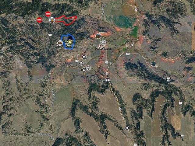
To view the map in Google Maps please click anywhere on the map above.
- Click to download a KMZ file (Note - in IE Right Click and choose Save Target as)
- Click to download a KML file (Note - KML files do not include custom icons)
- Click to download a GPX file (Note - in IE Right Click and choose Save Target as)
Caltopo Map showing various Points of Interest
In addition to a Google Map of Devils Tower I have also added a Caltopo Map that can be accessed by clicking on the next icon. ![]() Caltopo maps have several advantages over Google maps and a few disadvantages. For most purposes Google Maps are more than adequate, but if you plan to do off-trail hiking Caltopo maps are preferable.
Caltopo maps have several advantages over Google maps and a few disadvantages. For most purposes Google Maps are more than adequate, but if you plan to do off-trail hiking Caltopo maps are preferable.
Caltopo Advantages
- Unlimited Folders, Google Maps are limited to ten
- Multiple map layers can be shown at once, for example you can display a satellite image overlaid with a topographic map
- Multiple line types such as solid, dashed, or dotted. This makes it easy to distinguish between road and hiking trails and between paved road and dirt roads
- Many more layer types
- Land ownership (BLM/BOR, NPS, USFS, Local, State, FWS, private) is shown
- Parcel data (name of person owing land) is available on some annual plans
- 10 Foot contour intervals
- Slope angle shading - anything over 30° makes most people uncomfortable
- Ability to print up to 48 inches by 48 inches and to export maps
- Latitude and longitude are displayed as is elevation
- Elevation profiles are available for routes and trails
Disadvantages
- Caltopo can display Google satellite maps but cannot export or print them. Caltopo's built in aerial maps are not as detailed as Google satellite maps
- Photos cannot be attached to points of interest
- The items in a Caltopo folder are sorted alphabetically, custom order is not supported
- Some features of Caltopo are only available in paid plans
USGS 24K Topo Maps
Devils Tower is covered by the Devils Tower topographic map.
| Geo Tiff/Avenza | KMZ | Oruxmaps | KMZ Decollared | Oruxmap Decollared | Avenza Decollared |
| Devils Tower | KMZ | Oruxmap | KMZ Decollared | Oruxmap Decollared | Avenza Decollared |
