Cedar Wash Arch
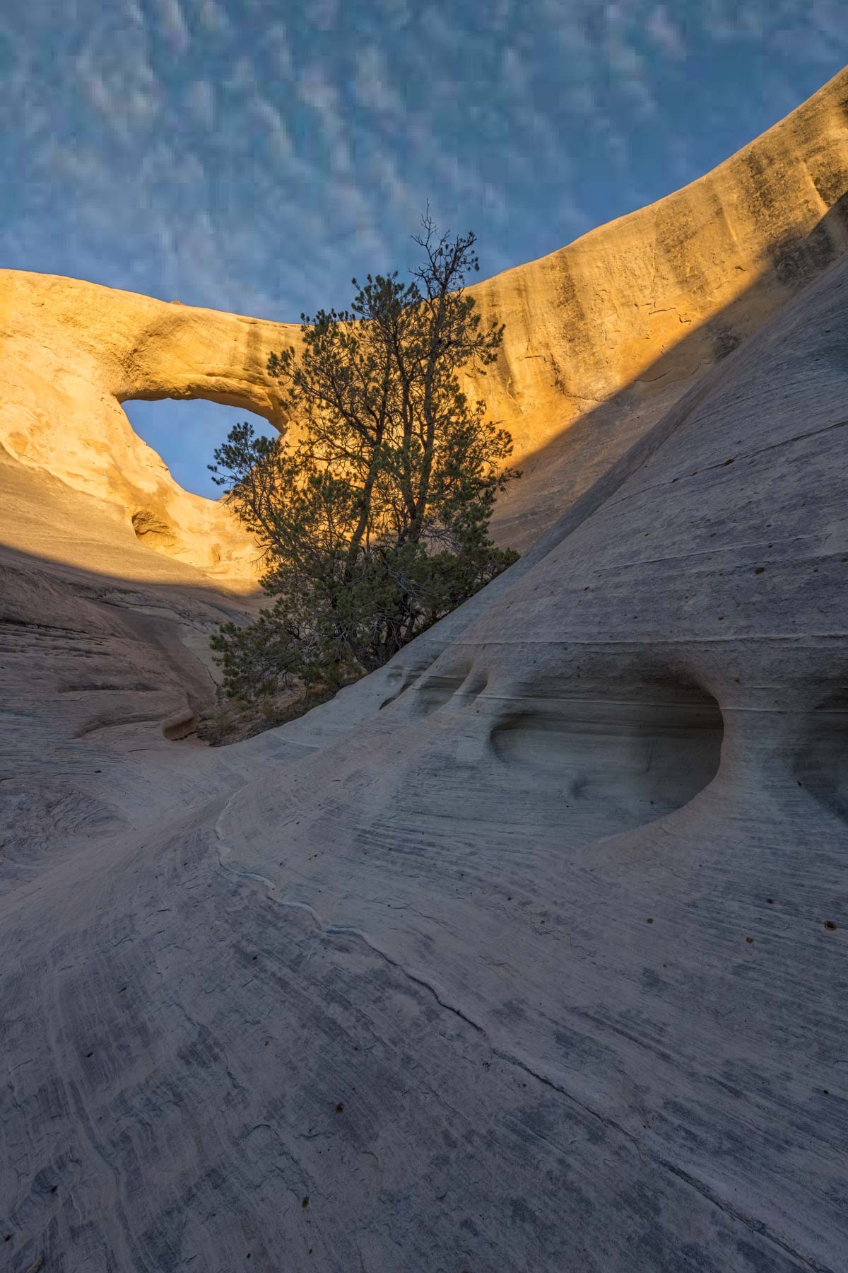
Cedar Wash Arch is a spectacular arch in the Grand Staircase Escalante National Monument. It is ten miles from the town of Escalante. The arch has a span of 24 feet. The arch is made of Entrada sandstone and is white in color. Most people photograph the arch from the top of the surrounding cliffs but the arch photographs much better from below. Some possible shooting locations are shown on the Google map that follows. The cliffs surrounding the arch are finely detailed and contain many surface pockets / tafoni formed over geological times by water streaming down the cliffs. The tafoni make excellent foreground, as do the pine trees in the area. The arch gets its best light in fall / winter and is best shot shortly after sunrise. Harsh shadows are present at dusk so if you go in the afternoon plan to be there a few hours before the sun sets.
There are many other locations to shoot in the area including Devils Garden, Twentymile Tracksite, Zebra slot canyon, and Covered Wagon Arch. In mid October the cottonwoods in the Grand Staircase change color making this the best time of the year to visit.
Getting there
The best route to the trailhead is via Hole in the Rock Road. From the intersection of Main and Center Street in Escalante take Highway 12 4.9 miles east to Hole in the Rock Road. Turn right and take Hole in the Rock Road 3.4 miles south To Cedar Wash Road. Cedar Wash Road is normally passable to private passenger cars. After a heavy rain parts of it may wash out. In this case the alternate route via Center Street in Escalante (shown below) is preferable. From Hole in the Rock Road make a right and take Cedar Wash Road 3.6 miles west to the trailhead.
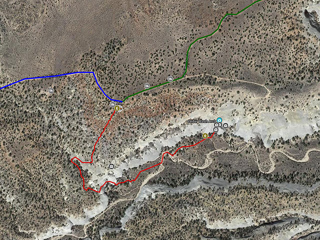
The hike from the trailhead is only 1.3 miles RT. It is not well marked. I suggest you download the track below and follow it until you get to the wash below the arch.
From the trailhead go south southwest about .2 miles to the entrada cliffs above the arch. The arch can be see to the east. If you plan to shoot from the cliffs a telephoto lens (200 mm or so) will be needed with mid-afternoon the best time to shoot. To shoot the arch from below you will need to make your way down the steep cliffs. I could only find one route down. The route requires walking on or just above an exposed ledge at roughly 37.6590, -111.5452. If there is snow or ice on the route or you are afraid of heights you will not be able to do this. Otherwise it is not difficult. When I hiked to the arch in 2020 there was a downed tree ten yards right of the narrow ledge that some people used as a bypass. I thought the ledge looked much easier.
Once below the cliffs find your way down the wash to the base of the arch. Several possible shooting locations are shown on the map. The best is labeled Sunrise Viewpoint and is at 37.6608, -111.5403. Foreground consists of a pine tree in a large circular depression. The pine leans to the right. I suggest you rotate your camera clockwise so that the pine appears to be straight up.
Views from the other side of the arch at sunrise are excellent also. Shoot from the wash just below the cliffs or gain the bench to shoot sun-stars or the tafoni as foreground. The arch forms a very nice shadow just after sunrise.
Since the arch is best at sunrise and the trail is hard to follow I suggest you visit the arch the afternoon before to establish your route. There is a lot of dry camping along Cedar Wash Road suitable for RVs or tents. A few possibilities are shown on the map below. Most of the land along the road is BLM so dispersed camping is allowed. There is a small posted area that is private, do not camp there. Lodging is available in the nearby town of Escalante.
Maps
Here is a Google map of the Cedar Wash Arch area:
To view the map in Google Maps please click anywhere on the map above.
- Click to download a KMZ file (Note - in IE Right Click and choose Save Target as)
- Click to download a KML file (Note - KML files do not include custom icons)
- Click to download a GPX file (Note - in IE Right Click and choose Save Target as)
Caltopo Map showing various Points of Interest
In addition to the Google Map of Cedar Wash Arch I have also added a Caltopo Map that can be accessed by clicking on the next icon. ![]() Caltopo maps have several advantages over Google maps and a few disadvantages. For most purposes Google Maps are more than adequate, but if you plan to do off-trail hiking Caltopo maps are preferable.
Caltopo maps have several advantages over Google maps and a few disadvantages. For most purposes Google Maps are more than adequate, but if you plan to do off-trail hiking Caltopo maps are preferable.
Caltopo Advantages
- Unlimited Folders, Google Maps are limited to ten
- Multiple map layers can be shown at once, for example you can display a satellite image overlaid with a topographic map
- Multiple line types such as solid, dashed, or dotted. This makes it easy to distinguish between road and hiking trails and between paved roads and dirt roads
- Many more layer types
- Land ownership (BLM/BOR, NPS, USFS, Local, State, FWS, private) is shown
- Parcel data (name of person owing land) is available on some annual plans
- 10 Foot contour intervals
- Slope angle shading - anything over 30° makes most people uncomfortable
- Ability to print up to 48 inches by 48 inches and to export maps
- Latitude and longitude are displayed as is elevation
- Elevation profiles are available for routes and trails
Disadvantages
- Caltopo can display Google satellite maps but cannot export or print them. Caltopo's built in aerial maps are not as detailed as Google satellite maps
- Photos cannot be attached to points of interest
- The items in a Caltopo folder are sorted alphabetically, custom order is not supported
- Some features of Caltopo are only available in paid plans
USGS 24K Topo Maps
The Dave Canyon map contains contains the entire area around the arch. As is now my practice I have provided GeoTIFF, KMZ, and Oruxmap formatted files, click or right click below to download.
| Geo Tiff/Avenza | KMZ | Oruxmaps | KMZ Decollared | Oruxmap Decollared | Avenza Decollared |
| Dave Canyon | KMZ | Oruxmap | KMZ Decollared | Oruxmap Decollared | Avenza Decollared |