Buffington Pockets and Hidden Valley
Buffington Pockets is an area of striped pink, yellow, white, orange, and red Aztec sandstone east of Las Vegas, Nevada. The area is named for its many small depressions that collect water. Although Buffington Pockets is only ten miles southwest of Valley of Fire State Park, it is much more difficult to access. Best access is via the Valley of Fire Highway. From Las Vegas take I-15 to exit 75 Valley of Fire. Take Valley Of Fire highway 3.1 miles and bear right onto the good graveled Old Spanish trail road. After four miles, Old Spanish Trail road becomes the Bitter Springs Trail Back Country Byway. The change in names marks the beginning of Buffington Pockets. Unlike the Old Spanish Trail, Bitter Springs Trail is quite rough and a high clearance 4x4 with good tires is needed to continue further into the pockets.
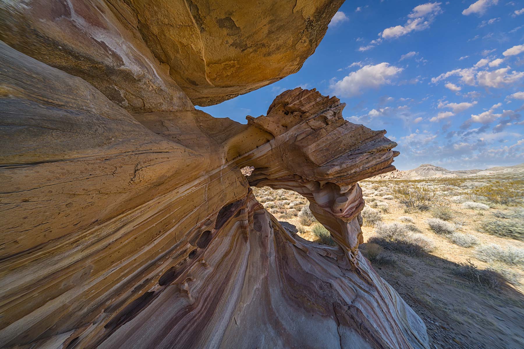
Buffington Pockets consists of 170 million-year-old Aztec sandstone mostly covered by Cambrian Dolostone limestone 500 million years old. It was formed when the Pacific Plate collided with North America 70 to 160 million years ago. The Dolostone mountains of the Pacific Plate thrust over the younger sandstone of what is now southern Nevada when this occurred. In the image above the arch is made of Aztec sandstone and you can see the gray Dolostone at the top of the peak framed by the arch.
I've divided Buffington Pockets into four main areas each accessed by a different road. The Bitter Springs Trail region is the most visited area. I suggest you hike the Petroglyph trail shown on the map below at a minimum. If you are comfortable with off-trail hiking park at any of the many roadside campsites and explore the Aztec sandstone. Look for small arches and other interesting formations. Drainages in the more colorful areas often contain arches.
Color Rock Quarry contains a colorful heavily graffitied miner's cabin, many small colorful arches, and alternative access to Hidden Valley via the Ridge Trail. Access to Color Rock Quarry is via the signed ColorRock Road starting at 36.40644, -114.7085. The map below shows the route to the Miner's Cabin in yellow.
The northeast area contains many small arches. To access it take the unnamed 3.5 miles rough road starting just beyond the Color Rock Quarry turnoff at 36.40634, -114.70825. There is a good campsite for one or two cars at the end of the road.
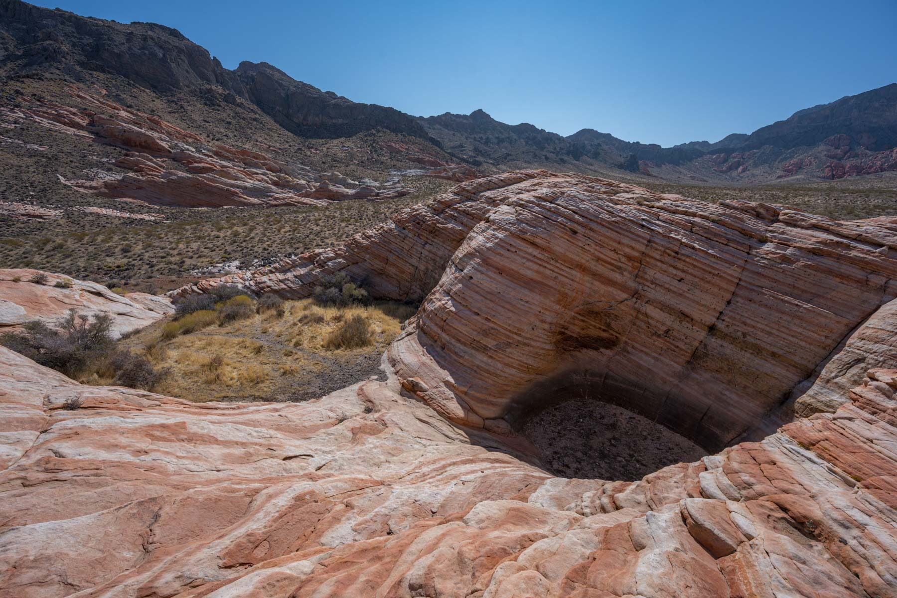
Hidden Valley is my favorite area of the four and contains many hidden gems such as the Striped Arch and the Tinaja shown above. Hidden Valley is about 2,500 acres in size. You are likely to have it all to yourself, except perhaps for rabbits and Bighorn sheep. I have been to Hidden Valley three times and only saw one other couple there. To get to Hidden Valley, take Bitter Springs Trail Road and turn right on the unsigned road at 36.34381, -114.67297. Take this road one mile to its end, where the Hidden Valley Wilderness area starts. This road is narrow. If you drive a full-size truck it is likely it will get some pin-striping. From the trailhead, proceed 0.3 miles up the now-closed road to a ridge-top saddle where you'll find Hidden Valley laid out before you to the west. There are great views to the east from the saddle as well. My favorite destination in the valley is Striped Arch. From the ridge top, continue down the abandoned road 0.4 miles and bear right when the road forks. Continue on the right fork 0.4 miles and look for the arch about 40 meters to the left. The best side of Striped Arch is its east side so photography is best at dawn. Unfortunately, it is front-lit at dawn for much of the year. Excellent images should be available near the summer solstice when it will be more side-lit.
Hidden Valley contains many other arches; look for them anywhere the Aztec sandstone is exposed.
When water is present in Hidden Valley, the tinaja (waterhole) at 36.3266, -114.6987 is also an excellent destination. There are three depressions on the small butte that contains the tinaja; the middle one is the most likely to have water. Unfortunately, there was none present on my two trips there. Since Las Vegas only gets about five inches of rain a year, a dry tinaja will usually be the case. Bighorn sheep frequent the tinaja when water is available in the area.
Google Map of Buffington Pockets and Hidden Valley
The following map shows the route to Buffington Pockets, a few of the attractions in the area, and the location of a few of the many campsites along Bitter SPrings Trail.
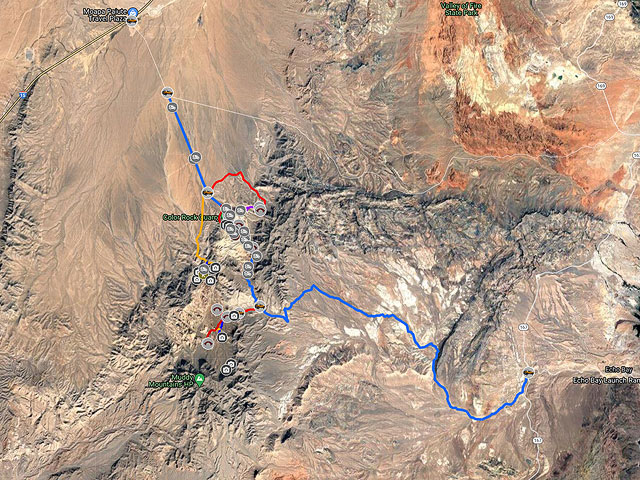
To view the map in Google Maps please click anywhere on the map above.
- Click to download a KMZ file (Note - in IE Right Click and choose Save Target as)
- Click to download a KML file (Note - in IE Right Click and choose Save Target as)
- Click to download a GPX file (Note - in IE Right Click and choose Save Target as)
Caltopo Map showing various Points of Interest
In addition to the Google Map of Buffington Pockets I have added a Caltopo Map. Caltopo maps show land ownership which is very important if you plan to boondock. You do not want to camp on private land, and US Forest Service, NPS, and BLM camping regulations are often different. Caltopo maps are also preferable for off-trail hiking since they show ten feet elevation contours and terrain slope shading.
USGS 24K Topo Maps
Buffington Pockets is covered by the Piute Point USGS topo map and Hidden Valley and Muddy Mountain by the Muddy Peak map.
| Geo Tiff/Avenza | KMZ | Oruxmaps | KMZ Decollared | Oruxmap Decollared | Avenza Decollared |
| Muddy Peak | KMZ | Oruxmap | KMZ Decollared | Oruxmap Decollared | Avenza Decollared |
| Piute Point | KMZ | Oruxmap | KMZ Decollared | Oruxmap Decollared | Avenza Decollared |
| Map of the entire area | NA | NA | KMZ Decollared | Oruxmap Decollared | Avenza Decollared |