The Bisti Badlands
The Bisti Badlands is one of the most scenic areas in the West and the best in New Mexico. It is a magical place to visit. It is the western part of the 38,305-acre Bisti/De-Na-Zin Wilderness and is in the Four Corners area. It is less than an hour south of Farmington, NM, or 3 hours from Albuquerque. Bisti is pronounced (Bis-tie). Fall is the best time to visit. If you go in the summer, bring a lot of water. Spring is the windy season in the southwest, and sandstorms are common. The Bisti / De-Na-Zin average elevation is 6,300 feet, so winters will be cold. Fall days are pleasant, and days are shorter. Strong hikers can be out at both sunrise and sunset. The access road to the Bisti is gravel, so the parking area is accessible after rain. However, the clay-based soil would be difficult to hike after rain.
There are two main washes in the Bisti. Both run east to west, with west being downstream. The northern wash is Hunter Wash, and the southern is Bisti Wash. The main parking area provides access to Bisti wash, so you should start here for your first trip to the Bisti. You are likely to see other people in Bisti wash. Seeing others will give comfort if you are unsure of your navigation skills. The northern wash gets far fewer visitors but provides the shortest route to the northern sections of the badlands.
There are no hiking trails in the Bisti. If you stay in the main washes and get lost, you can always find your way back to your car by following the washes downstream (west) till you hit the road. Then walk along the road till you get to your car. You can easily get lost if you go into the hills on either side of Bisti wash. Being in the hills is like being in a maze; there are many dead ends, and you can easily lose your sense of direction. If you plan to explore the hills, bring a GPS and mark the location of your car and where you left the main wash.
If you're without a GPS, I suggest you stay in Bisti wash. There are plenty of great photo opportunities, such as the "Cracked Eggs" and the "Rock Garden". If you explore the hills, the area near the "Bisti Wings" is highly photogenic, with many compositions possible. You can also cross over into Hunter Wash from The Wings. Petrified Cove is also photogenic and contains long petrified logs and a rarely visited arch.
Several days are needed to explore the Bisti. You cannot get to all the best locations in The Bisti in good light in one day.
If you only have one day, I suggest you begin an hour before dawn with a two-mile hike to the "Rock Garden" section. You'll need a flashlight. The "Rock Garden" lights up beautifully at sunrise. You can also get excellent pictures during the "Blue Hour" - the half hour before sunrise or after sunset. The soft shadows and mudstone pick up a beautiful blue-gray color during the Blue Hour. After an hour or so at the Rock Garden, visit the "Elegant Hoodoo" and the "Alien Woman" section.
After exploring the Rock Garden, enter the hills to see The Wings. The Wings are spectacular at dusk and dawn and even at night. When you visit The Wings, do more than just capture them from a distance. Get up close and personal. It is easy to find a route down into the wash between The Wings Overlook and The Wings. Once in the wash, you can climb up to The Wings from their northeast side. On the way to the Bisti Wings, you will pass many other good photo ops, including Red Rock Garden, The Pedestals, and The Manta Ray. Cross to the south side of Bisti wash a few hours before sunset. Explore the south side of Bisti wash, starting in the Petrified Cove area looking for fossils and petrified wood. Do not remove any fossils or petrified wood. End your day at sunset with the "Cracked Eggs". Cracked Eggs is also a good Blue Hour or even nighttime shoot, and you will probably see other photographers there.
Photography
The Bisti badlands are gray to green/gray with occasional muted browns and reds. The badland's lack of color makes them hard to photograph. To add much-needed color and contrast to your photos, shoot at sunrise or sunset or in the blue hour. I shot my best images then. Partly cloudy or dramatic skies can help your Bisti images as well.
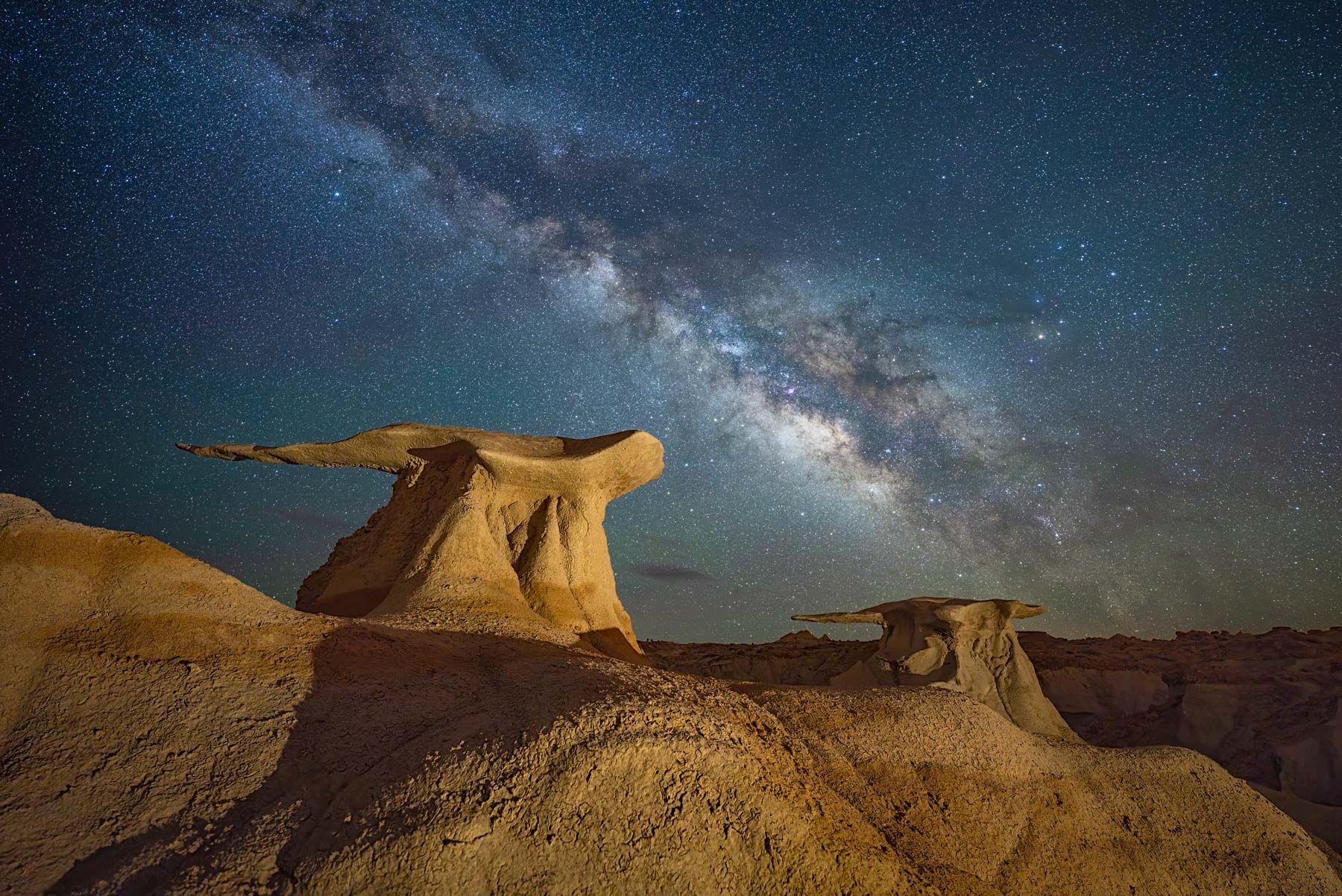
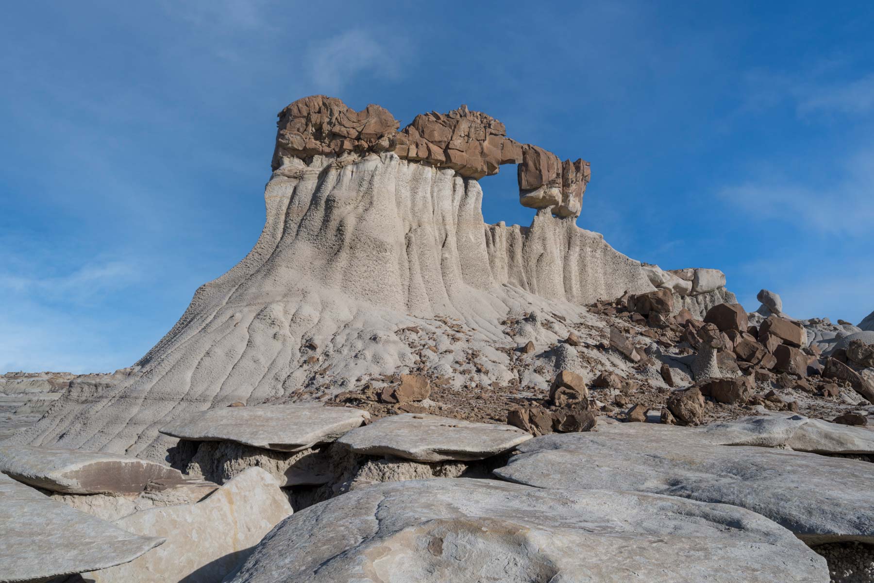
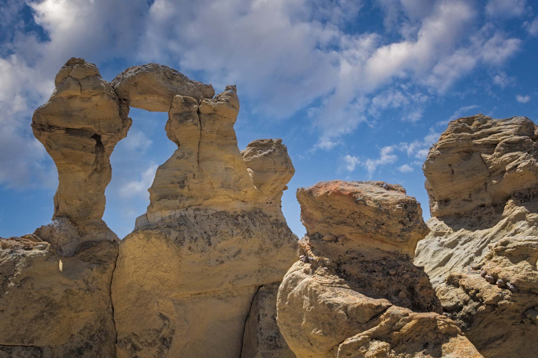
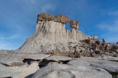
The Bisti Wings
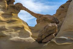
This incredibly shaped rock formation is the crown jewel of the Bisti. In a sixty-foot by ten-foot area, there is a beautiful naturally sculpted arch and two wings. The area has many names: The Wings, Three Wings (I only see two?), Stone Wings, The Seal, The Klingon Bird of Prey Arch, and The Turtle. The variety of names mirrors the many compositions available at sunrise and sunset. The Blue Hour is an excellent time to shoot the pastel-colored wings. The Wings also make a good foreground for the Milky Way, but beware of the red hue generated from a light in the distance. Like the reds produced by red flashlights, the hue is difficult to remove in post-processing. The Hunter Wash trailhead provides the best access to the wings via an easy 1.1-mile flat hike. If you take this route, stop at the photogenic Capped Rocks. The main Bisti trailhead provides access to the Wings via a two-mile hike. The map below shows both routes.
GPS Coordinates: 36.27927, -108.23735
Rating: *****
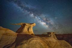
The Bisti Wings
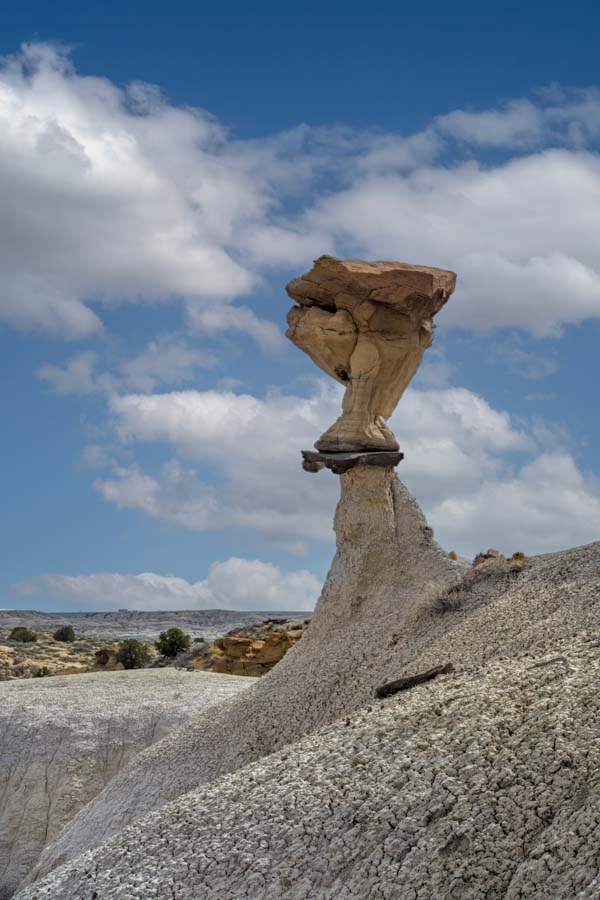
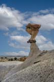
Conversing Hoodoos
These tall, elegant hoodoos are also known as the Talking Hoodoos or the Bonnet Hoodoos. They are best in the morning but also get nice edge light at sunset. They also make a good foreground for the Milky Way when it is more vertical in the sky and to the southwest. Vertical Milky Ways occur in early fall to mid-fall. Light Painting or low-level LED lighting should work well here. The Conversing Hoodoos are on the south edge of Hunter Wash and only a quarter-mile from the Wings. They are also within a quarter-mile of Dodo Bird Hoodoo and Clam Hoodoo Arch.
GPS Coordinates: 36.28116, -108.23585
Rating: ****
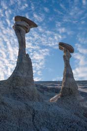
Conversing Hoodoos
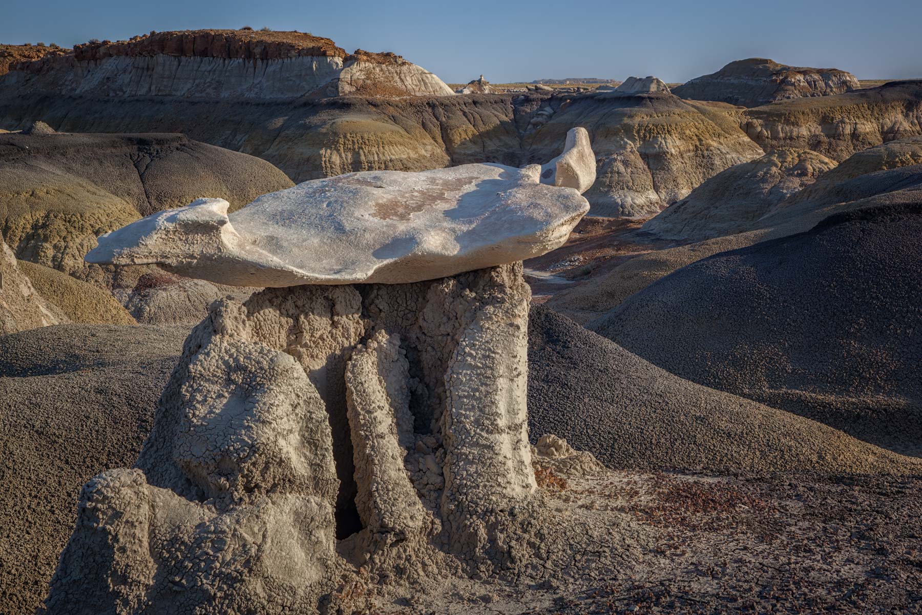
Cracked Eggs
This formation of low, weathered concretions is the best known in the Bisti Badlands. The area is also referred to as the Alien Hatchery or the Egg Hatchery. Due to a small ridge to the east first light only hits the eggs 30 minutes or so after sunrise during most of the year, so sunset is slightly preferable to sunrise, but both work well. You'll likely have other photographers present at sunset. Cracked Eggs are an excellent Blue Hour location and are a great foreground for the Milky Way. The image of the Milky Way on the right was taken in mid-April from the Egg's northwest side. Later in the year, when the Milky Way is more to the south, more compositions would be available. The eggs are a flat two miles from the main Bisti trailhead.
GPS Coordinates: 36.2674, -108.22374
Rating: *****
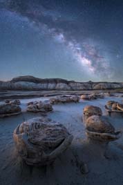
Cracked Eggs
Manta Ray
This formation is difficult to photograph because of the area's many other rocks and hoodoos. The Manta Ray is nearly en route from the main Bisti parking to The Wings. Also on the same route are the Red Rock Garden and the Pedestal. Both of these are much easier to shoot than the Manta Ray.
GPS Coordinates: 36.27629, -108.23621
Rating: ****
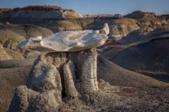
Manta Ray
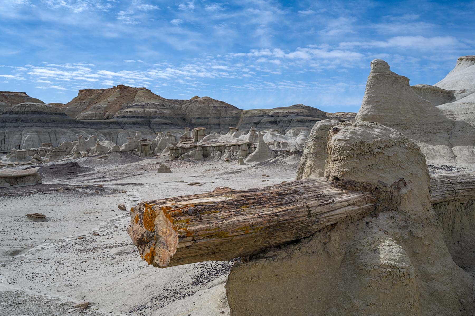
Petrified Cove
This area contains hoodoos and several long logs of petrified conifer trees. Root balls are visible for some of the logs, and most are fractured perpendicular to the trunk. Fractures in petrified wood occur across the shortest distance in the wood. It is like snapping a piece of chalk; it fractures horizontally, not vertically. Petrified Cove is about .2 miles east of the Cracked Eggs.
GPS Coordinates: 36.26718, -108.22005
Rating: ****
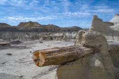
Petrified Cove
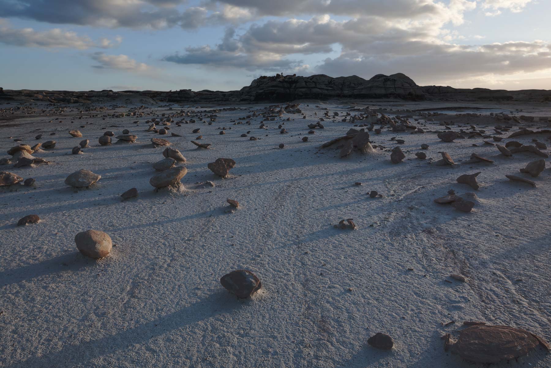
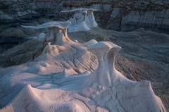
The Rock Garden
The Rock Garden comprises hundreds of small hoodoos, round rocks, and unimaginably shaped stones. The Hoodoos and stones are mostly less than one foot high. The garden is best shot at sunrise, and the blue hour works as well. The Rock Garden is on the north side of Bisti Wash and is .25 miles from Cracked Eggs.
GPS Coordinates: 36.2704, -108.22541
Rating: ****

The Rock Garden
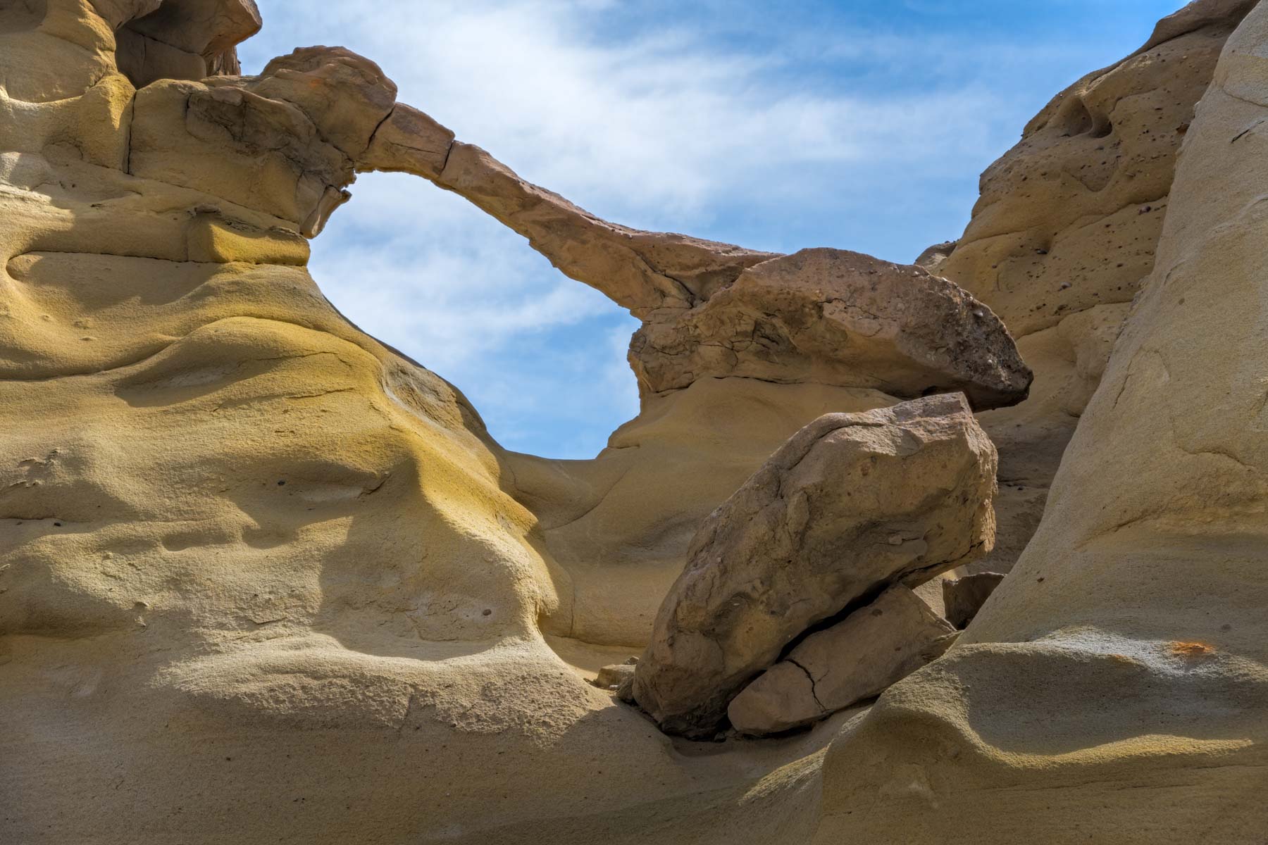
Two Windows
Walking north across Bisti Wash, starting at Cracked Eggs, you'll see a small arch in the distance. This arch is one of two arches known collectively as The Two Windows. The World Arch database shows one of the two arches under the name The Two Windows. I've named the individual arches the Northeast Window and the Southwest Window to distinguish them. The openings in both are about five feet wide. The Northeast Window is the more photogenic of the two and is best after sunrise.
GPS Coordinates: 36.27282, -108.22424
Rating: ****
Two Windows
Two-Headed Hoodoo
This unusual hoodoo is only .25 miles from the western boundary of the Bisti. Best sunrise. Access is via an off-trail hike starting at 36.26845, -108.25647. Go under the barbed wire fence and hike east to the eggs.
GPS Coordinates: 36.26906, -108.25187
Rating: ****

Two-Headed Hoodoo
Bisti Egg Garden
Unlike the "Cracked Eggs section of the Bisti, the eggs in this garden are whole! The Egg Garden is only .25 miles from the western boundary of the Bisti. Access is via an off-trail hike starting at 36.26845, -108.25647. Go under the barbed wire fence and hike east to the eggs. Good at both sunrise and sunset and in the blue hour.
GPS Coordinates: 36.26833, -108.25231
Rating: ****

The Egg Garden
De-Na-Zin
De-Na-Zin comprises the eastern part of the Bisti / De-Na-Zin Wilderness. Like the Bisti badlands, there are no real trails here. The routes shown in OpenStreetMap were challenging to follow and occasionally involved class 3 scrambles. Conversely, the Alltrails De-Na-Zin Section Trail was easy to follow but unfortunately did not get you to the best features in the area. On the map below, I've laid out three routes that get you to the best-known features in De-Na-Zin. The routes follow existing trails wherever possible and take you to three good destinations: De-Na-Zin Arch, Right Angle Arch, and Collared Hoodoo.
De-Na-Zin is infrequently visited. On a Saturday in April of 2023, there were about half a dozen cars at the trailhead parking lot, mid-week we saw only one other car on two separate days.
Collared Hoodoo
This hoodoo is like a hoodoo on top of a hoodoo. I first saw it while hiking in the De-Na-Zin wash below and found it the next day, just below the wash's south rim. I've seen other images on the web, but no name was given, so I've named it Collared Hoodoo. The west side of the hoodoo is slightly more photogenic than the east side, so sunset works best, but sunrise is also good. The hike to the hoodoo is about one mile. From De-Na-Zin parking, follow the main trail 1000 feet to a faint two-track heading west. Follow the two-track for about 0.6 miles until another two-track comes from the south. From here, continue off-trail in a northerly direction until you spot the hoodoo on the rim.
GPS Coordinates: 36.31467, -108.01416
Rating: ****
Collared Hoodoo
De-Na-Zin Arch
This arch is on the south rim of De-Na-Zin Wash, about one mile from De-Na-Zin parking. The arch has an eight-foot opening, and the good side faces northwest, so the best light will be from mid-afternoon to sunset. The best view is from the northwest, but both sides of the arch photograph well. You'll need a wide-angle lens if you shoot from the southeast. Stop at Collared Hoodoo on the way to the arch.
GPS Coordinates: 36.31303, -108.01855
Rating: ****
De-Na-Zin Arch
Right Angle Arch
This arch is on the north rim of De-Na-Zin Wash, about 1.5 miles from De-Na-Zin parking. The arch is on several websites under the name De-Na-Zin Arch, which is unfortunate since the World Arch Database already uses this name for another arch. To avoid confusion, I've renamed this arch "Right Angle Arch" and will report it to the World Arch Database with this name. You can shoot the arch from either side. It opens to the southeast and is best at sunset in late spring and early summer and at sunrise in late fall / early winter. On the way to/from the arch, stop at the Big Hoodoo. It's quite good at sunset.
GPS Coordinates: 36.31895, -108.01803
Rating: ****

Right Angle Arch
Weather and Climate
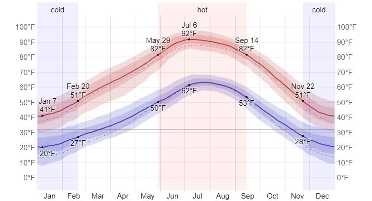
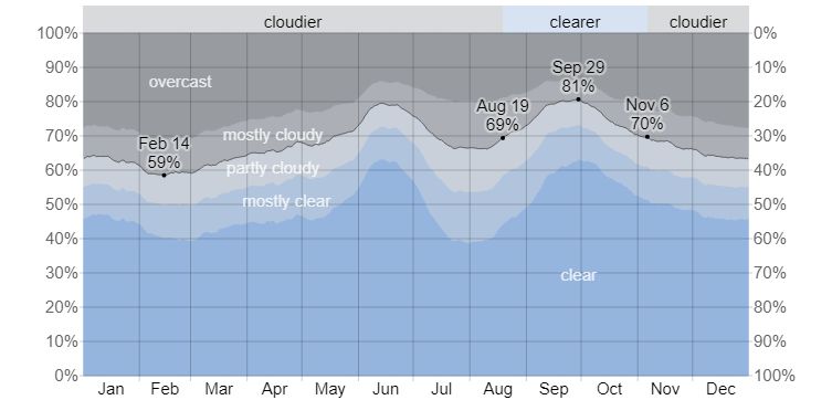
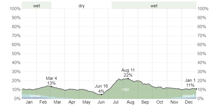
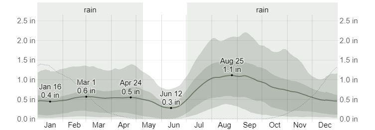
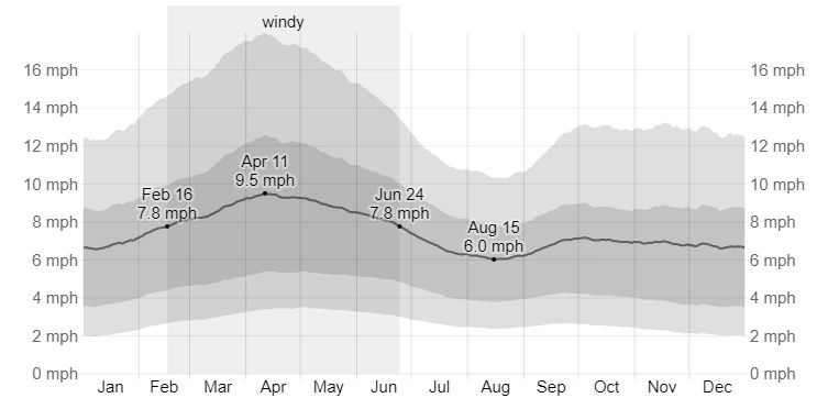
Farmington, New Mexico, is the closest town to the Bisti Badlands with available climate data. Farmington is 500 to 1,000 feet lower in elevation than the Bisti Badlands, so expect temperatures at the Bisti to be three to five degrees cooler than in Farmington. The following graphs are from weatherspark.com. In addition to the data shown here, Weatherspark also includes data on wind direction and snowfall.
Current weather and forecasts are available at the following sources:
- Weather Underground - Farmington, NM
- Accuweather - Farmington, NM
- Weather.com - Farmington, NM
- NWS - Bisti Badlands Point Forecast
Maps and Directions
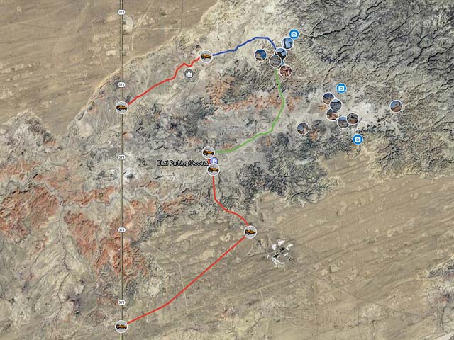
There is no formal parking area for the northern (Hunter) wash, and the BLM Site does not even mention parking there. I have indicated a possible area to park on the map below. A high-clearance vehicle is recommended. Parking at Hunter Wash provides the shortest and easiest access to The Wings, a bit over one mile over flat terrain. Hunter Wash itself is not as attractive as Alamo Wash.
To access the Bisti Wash section, go 36.5 miles south of Farmington on NM 371 until you get to road 7297 signed for the Bisti Badlands. Make a left (East) turn on this good gravel road. Four-wheel drive or high clearance vehicles are not needed for this good road. Proceed two miles to the junction and make a left, then go about one more mile to the parking area on the right side of the road. There is no water or facilities other than a restroom at the parking area. You can camp at either the parking area or within the Bisti itself. I've also noticed RVs camped at pullouts on both sides of the road to Bisti's main parking. No wood fires are allowed. Please do not trespass on signed or fenced private property.
There is a second small parking area just past the main parking area. Depending on conditions, you may need a 4x4 to get to it. Just past the main parking, cross the signed wash and continue 0.2 miles to parking on the right.
Google Map and Directions
The Google map below contains driving directions and locations of many photogenic features in the Bisti / De-Na-Zin Wilderness.
To enlarge the map and view it in Google Maps please click anywhere on the map above.
Google Maps have two sections. The left side of the map typically shows a legend. If the legend is hidden, click the "Map Legend" box on the upper left to reveal it. The legend includes a list of folders. To display or hide the contents of a folder, click the check box to its left. Folders contain locations and routes. Click on a place to display more information and possibly a cropped photo. Click on the cropped image to display a higher-resolution uncropped version. The legend's top right shows a magnifying glass icon and three dots (ellipsis). Clicking on the magnifying glass brings up a search box to find a particular location or route. The ellipsis gives you several options. You can collapse the legend so you can see more of the map, print the map, download a KML file for use with a GPS, or view the map in an online version of Google Earth.
The right side shows the map. To drag the map, hold the left mouse button down. To zoom in or out, use the mouse wheel or the +- box on the lower left. Clicking on a route or location brings up its details.
The online version of Google Earth helps measure distances and display GPS coordinates, elevations, and additional photos of the area. To measure distances, click the ruler icon at the bottom left. GPS coordinates and elevations at the cursor are displayed on the bottom right. Click the menu icon (three bars) on the upper right and drag the Photos slider to the right to reveal additional images.
- Click to download a KMZ file (Note - in IE Right Click and choose Save Target as)
- Click to download a KML file (Note - KML files do not include custom icons)
- Click to download a GPX file (Note - in IE Right Click and choose Save Target as)
USGS 24K Topo Maps
Two topo maps cover the entire area of interest: Bisti Trading Post covers the roads to the trailhead, and Alamo Mesa West covers the area of photographic interest. The maps are handy in the washes but not so helpful in the surrounding hills, as the amount of detail shown won't help you avoid dead ends. The two maps and a merged map of both can be downloaded in a variety of formats by clicking or right-clicking below:
| Geo Tiff/Avenza | KMZ | Oruxmaps | KMZ Decollared | Oruxmap Decollared | Avenza Decollared |
| Alamo Mesa West | KMZ | Oruxmap | KMZ Decollared | Oruxmap Decollared | Avenza Decollared |
| Bisti Trading Post | KMZ | Oruxmap | KMZ Decollared | Oruxmap Decollared | Avenza Decollared |
| Merge of both maps | NA | NA | KMZ Decollared | Oruxmap Decollared | Avenza Decollared |