Aztec, New Mexico
Aztec, New Mexico is the home of Aztec Ruins National Monument, a 450 room ancient pueblo site. Aztec Ruins is a UNESCO World Heritage Site, of which there are only 21 in the United States. The Aztec area is also home to over 300 arches, perhaps the largest concentration of arches in the US outside of Arches National Park. While most of these arches are small, several are quite photogenic, and well worth exploring and shooting. If you are visiting the four corners area Aztec merits a stop, perhaps in combination with the Bisti Badlands, the Durango area, or Mesa Verde.
Aztec Ruins National Monument
Early settlers mistakenly thought that people from the Aztec Empire in Mexico created the buildings of Aztec Ruins. This misnomer still persists. Aztec Ruins was actually built by the Ancestral Puebloan people. Tree ring dating shows that the site was built between 1106 and 1125 AD by people migrating from Chaco Canyon. Aztec Ruins consists of several "Great Houses" each with an associated "Great Kiva", and many smaller structures. Kiva is a Hopi word meaning ceremonial chamber. In about 1300 Aztec Ruins was abandoned. Many of its people migrated westward to present day Hopi villages. The most photographed part of Aztec Ruins is the Great Kiva. The Aztec Ruins Great Kiva is the only fully reconstructed puebloan great kiva. The kiva was reconstructed in 1934. Reconstruction of other ruins is unlikely today as current archaeological practice mandates study and preservation. So the Aztec Great Kiva is and will remain one of a kind. A photo of the Great Kiva before reconstruction appears on this webpage. Unrestored great kivas can be found at the Chaco Culture National Historic Park, or, closer to Aztec, at the Salmon Ruins. Salmon Ruins is just west of Bloomfield, NM.
The images of the great kiva in my gallery were shot around midday, a good time to shoot it. These images show that the Aztec Great Kiva has many features in common with other great kivas. These include a circular structure with north south oriented entrances and vaults, circumference benches, floor vaults, and a fire pit. One unique feature of the Aztec Great Kiva is the presence of fifteen "supplementary chambers" around the outside of the kiva. Their purpose is unknown. You will need a wide angle lens and/or panorama setup to effectively capture the magnificence of the Great Kiva.
The Aztec Ruins "Great House" is also worth shooting, especially the doorways shown here. The interior shown is quite dark. You will need a tripod to capture it, and should bracket your images. You'll also need patience as many visitors will walk through while you are shooting. While I normally recommend getting as close to your subject as possible, in this case you might want to stand back a bit so as to maximize the size of the interior doors relative the first door.
Aztec Ruins National Monument is open from 8:00 AM to 6:00 PM from Memorial Day through Labor Day, and from 8 to 5 the remainder of the year. A $5 fee valid for seven days is charged. There is no fee for annual or senior pass holders. The monument can be visited almost any time of the year with mid-October an especially good time for Fall Color along nearby Animas River. The ruins can be quite beautiful when snow covered, however if you plan to explore the arches in the Aztec area as well winter should probably be avoided. Slippery conditions along the roads and trails can make driving and hiking very dangerous then.
To get to Aztec Ruins from Farmington take Highway 516 northeast into the city of Aztec. 1/4 mile past Lightplant Road turn left onto Ruins Road. Follow Ruins Road 1/2 mile to the monument. From Bloomfield follow Highway 550 north into the City of Aztec, turn left at the “T” intersection onto Highway 516, drive 3/4 mile, and then turn right immediately after crossing the river onto Ruins Road. Follow Ruins Road 1/2 mile to the monument.
Aztec area arches
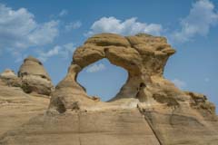
While almost all of the Aztec area arches are quite small, several are very photogenic. My favorites are Cox Canyon Arch, also known as Anasazi Arch, and Rooftop Arch, also known as Little Delicate Arch. The map below shows the location of several other photogenic arches in the area. All of these arches are off the beaten path and you will probably have them to yourself. The arches are predominately on the sides or tops of cliffs and close-up shots may not be possible. If you do attempt to hike or climb to the arches pay close attention to your route as there are several reports of hikers having difficulty getting back to their car after visiting these arches. A GPS will be helpful both for retracing your route, and for navigating back-country oil well access roads.
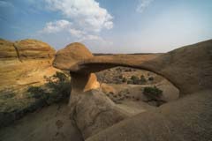
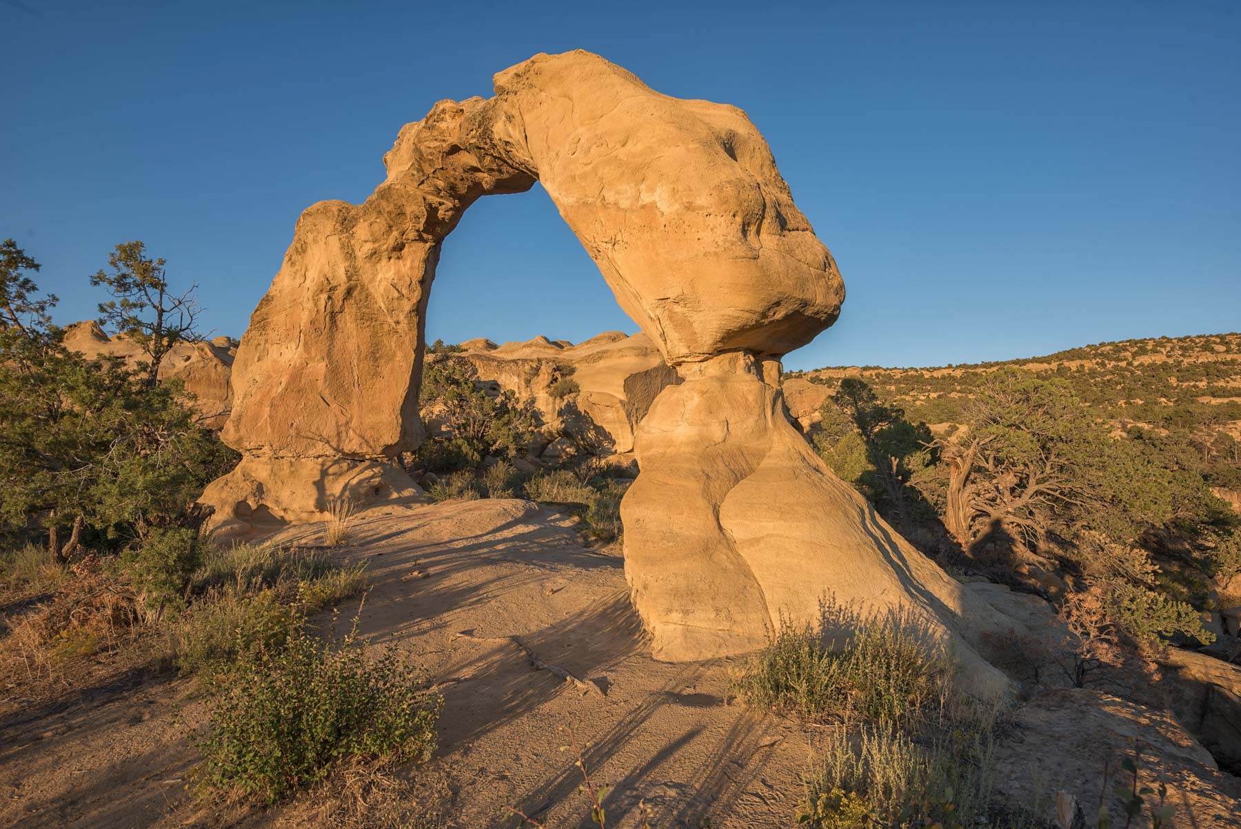
Cox Canyon Arch at Sunset
Cox Canyon arch is the best known of the Aztec arches. I have shot it both at sunrise and sunset and sunset is definitely better. It takes a long time for first light to reach the arch at sunrise. At sunset I suggest shooting the arch from one of its corners both to exclude the dead-on tree near the middle of the arch, and to use perspective to enhance the shape of the arch. On both of my visits there was dead tree trunk placed against the arches northeast side. The trunk together with some well-worn Moqui steps allows some people to climb the arch. This trunk is very distracting. I suggest moving it away from the arch before shooting. The top of the cliff just north of the arch is also photo worthy. If you have some extra time you may want to shoot the arch from there. The top can be accessed directly by good climbers, or hikers can access it via the track I've shown on the Google map below.
The hike to Cox Canyon Arch, while short (less than .5 miles), has two short scrambles. Some people will have trouble with these. Going with a friend who can lend a hand over these sections is helpful. As mentioned above, be sure to keep track of your route, especially if you are staying a bit past sunset. There is just one route back to your car! The trail to the arch is lightly cairned but gets little use and is hard to follow. I've shown my track to the arch on the map below, keep in mind that the track is only accurate to 20 feet or so, as is your GPS. If you reach a spot that looks difficult to climb and don't see a cairn nearby, you have probably lost the trail. You need to find it before proceeding.
To get to Cox Canyon Arch from Farmington take Highway 516 northeast through the city of Aztec until it becomes US 550. Follow US 550 10.9 miles and turn left onto Road 2300. Take 2300 1.3 miles and turn right onto 2310. Take 2310 2.7 miles and turn right onto the dirt road just past the oil facility. Follow the dirt road .25 miles to a small parking area on the left side. The parking area has room for a few cars. If you reach a circular turnaround you've gone too far.
Boulder Arch
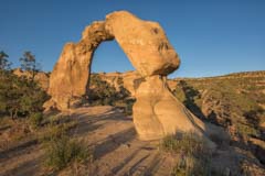
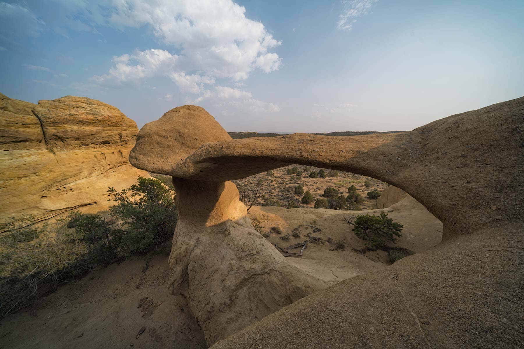
Rooftop Arch at Sunset
Rooftop Arch, also know as Little Delicate Arch, is small but lies in a very photogenic setting. It is best shot mid to late afternoon. At sunset it will be in shade for much of the year. When you first view Rooftop Arch it appears access from its level will be impossible. Access is actually quite easy; go north from the small parking area following a social trail, hike up the cliff, and then go southeast to the arch. The route I took is shown on the Google map below.
There are many other photogenic arches in the vicinity of Rooftop Arch. I have only been to one, Boulder Arch. Unlike Rooftop access to Boulder both looks difficult and is. It is easy to get to the top of the arch but dropping down to the bottom of the arch was beyond my abilities. Don't climb down to the arch if you are not sure you can get back up. Another person can help as will a rope to lower gear. The route to the top of the arch is shown on the map below.

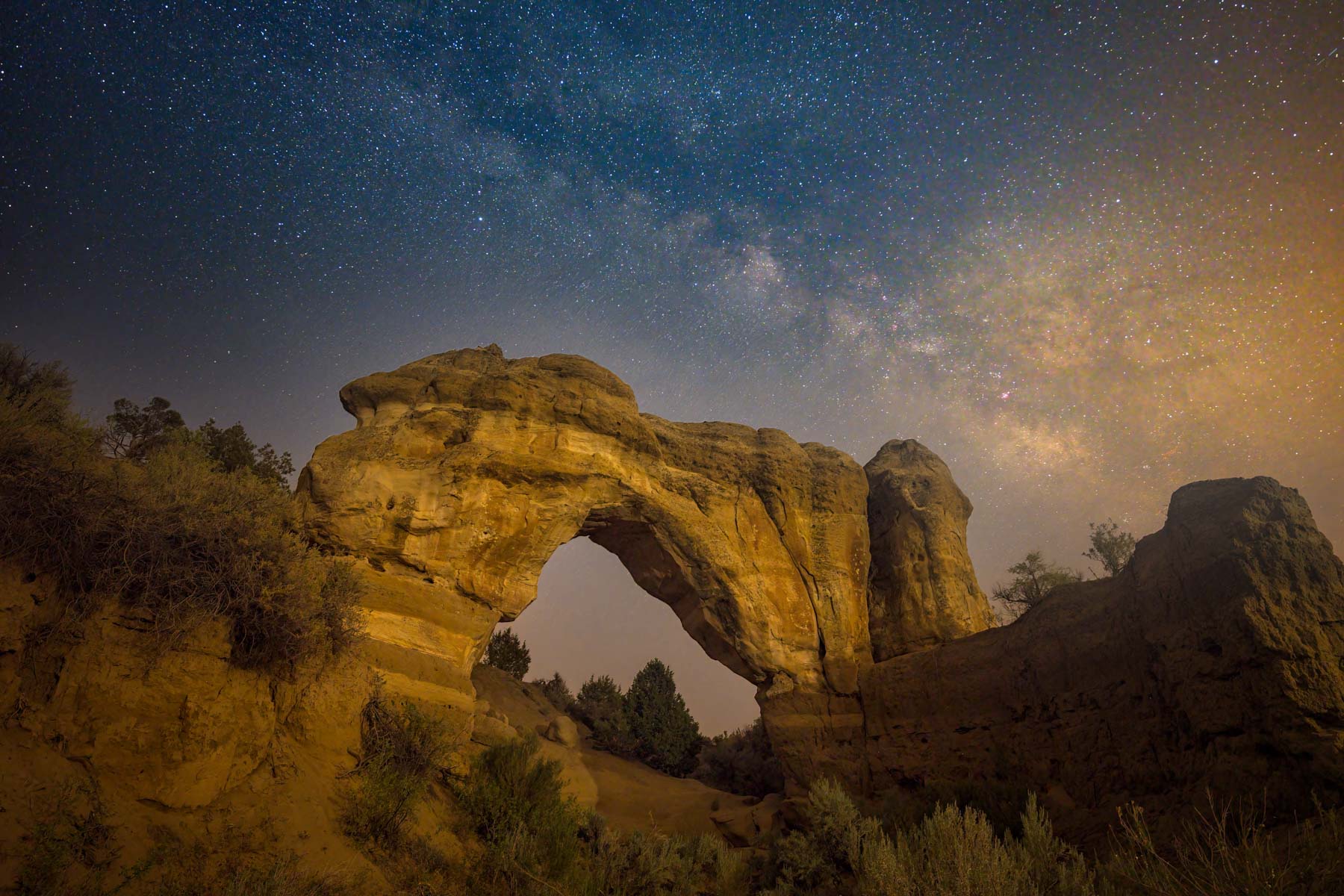
The Milky Way over Arch Rock
Arch Rock is about 30 minutes from the Rooftop Arch area. It should not be confused with the better known Arch Rock in Valley of Fire or Arch Rock in Joshua Tree National Park. Arch Rock is a massive stand alone arch. It is best shot at sunset or at night when the Milky Way is up. Arch Rock is right next to the parking area which makes it easy to shoot at night. The image to the right was shot in mid-July. There was a great deal of haze present that evening; Photoshop's De-haze filter did a good job of removing it. The arch was lit using a single LED panel placed on the cliff where you park. Wayne Pinkston has a spectacular image of Arch Rock lit by four lights.
Google map of the Aztec, New Mexico area
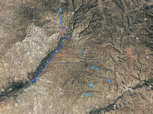
To view the map in Google Maps please click anywhere on the map above.
- Click to download a KMZ file (Note - in IE Right Click and choose Save Target as).
- Click to download a KML file (Note - KML Files do not include custom icons).
- Click to download a GPX file (Note - in IE Right Click and choose Save Target as).
USGS 24K Topo Maps
The Aztec area is covered by six USGS 24K maps. These maps can be downloaded in a variety of formats below:
| Geo Tiff/Avenza | KMZ | Oruxmaps | KMZ Decollared | Oruxmap Decollared | Avenza Decollared |
| Anastacio Spring | KMZ | Oruxmap | KMZ Decollared | Oruxmap Decollared | Avenza Decollared |
| Archuleta | KMZ | Oruxmap | KMZ Decollared | Oruxmap Decollared | Avenza Decollared |
| Aztec | KMZ | Oruxmap | KMZ Decollared | Oruxmap Decollared | Avenza Decollared |
| Cedar Hill | KMZ | Oruxmap | KMZ Decollared | Oruxmap Decollared | Avenza Decollared |
| Mount Nebo | KMZ | Oruxmap | KMZ Decollared | Oruxmap Decollared | Avenza Decollared |
| Turley | KMZ | Oruxmap | KMZ Decollared | Oruxmap Decollared | Avenza Decollared |
| Merge of all six maps | NA | NA | KMZ Decollared | Oruxmap Decollared | Avenza Decollared |
