Alstrom Point
Overview
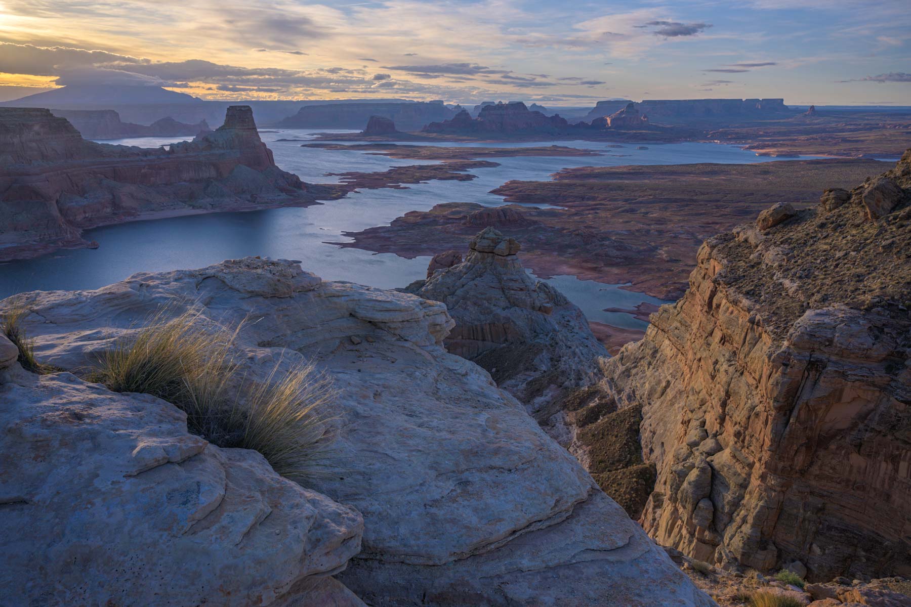
Gunsight Butte at Sunset
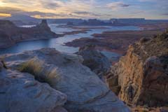
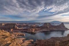
Early Light on Alstrom Point
Alstrom Point is considered to be the best overlook of Lake Powell. It is about 90 minutes from Page. The route to Alstrom Point is well described in the book "Backcountry Adventures Utah". This book is out of print and therefore expensive, if you can find a cheap copy I suggest you buy it. Backcountry Adventures Utah is the offroaders bible to Utah 4x4 roads. This book rates the road to Alstrom Point as a 3 on a scale of 1-10 for difficulty. This means a high clearance four wheel drive vehicle is preferred but any high clearance vehicle should be able to handle it. For the last two miles the road travels over slickrock and can be difficult to follow as there are many branches to other viewpoints. I suggest you download and follow the attached map. If this is your first trip to Alstrom Point allow at least two hours to get to the point from Page. The extra time will be needed if you have difficulty following the road. There are occasional cairns (small rock piles) to mark the way for the last two miles or so.
Alstrom Point is best shot at sunset or just after it. If you are driving out at sunset you should leave Alstrom Point early enough to ensure you do not get lost. Do not stay past sunset (the Blue Hour) unless you are sure you can follow the route back for the first two miles. Sunrise at Alstrom Point can produce good images as well, especially of the layers across the lake to the south. At sunrise Gunsight Butte will be in shadow though. Consider camping at Alstrom Point overnight and driving out the next morning. Alstrom Point is at relatively low elevation (4,600 feet) and is often be snow free when the rest of southern Utah is snow covered. Alstrom Point is a good winter location although Gunsight Butte will be front lit in this season. On the plus side there will be far fewer boats on the lake in the winter.
Alstrom Point is a good location from which to photograph the full moon. You can photograph it over Gunsight Butte (with a wide to normal lens) in the Spring and Fall, or over the other side of Lake Powell with a telephoto lens. The best views at Alstrom Point are to the south and east, so the full moon should be shot at moonrise (sunset). The sunset full moon is best shot 1-2 days before the moon is full. TPE can help you plan these shots.
Route
Coming from Page take US 89 west 14.4 miles (measured from the Glen Canyon Visitor Center) to Ethan Allen Way in Big Water. Take Ethan Allen Way 0.3 miles and make a right onto Glen Canyon National Park Road. In another 0.5 miles you will reach Wahweap Creek which normally has a little water in it. It should be easy to cross. Follow this good gravel road 13.1 miles from the creek crossing to the intersection with Smoky Mountain Road and bear right onto Recreation Road 230. Take Recreation Road 230 4.2 miles to the intersection with Recreation Road 264 and turn right. After about 4.5 miles Recreation Road 264 officially ends. It becomes an unnamed road and travels over slickrock for about 2 miles to Alstrom Point. The road is cairned but can be hard to follow. The roads on the other side of Wahweap Creek are impassable when wet after you leave the graveled sections.
Here is an overview map showing the drive to Alstrom Point:
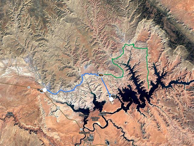
To view the map in Google Maps please click anywhere on the map above.
- Click to download a KMZ file (Note - in IE Right Click and choose Save Target as)
- Click to download a KML file (Note - KML files do not include custom icons)
- Click to download a GPX file (Note - in IE Right Click and choose Save Target as)
USGS 24K Topo Maps covering Alstrom Point and Lake Powell
Lake Powell is covered by 31 USGS 24K topo maps. Alstrom Point is covered by Gunsight Butte and Warm Creek Bay. Alstrom Point is right on the intersection of these two maps so you should download both. The Wild Horse Mesa and Page maps cover the area on the other side of Lake Powell should you wish to identify POIs on the south side of the lake. All Lake Powell topo maps can be downloaded from this site on the Lake Powell map page.