Drones
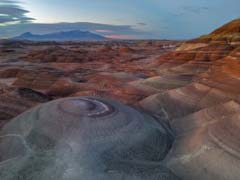
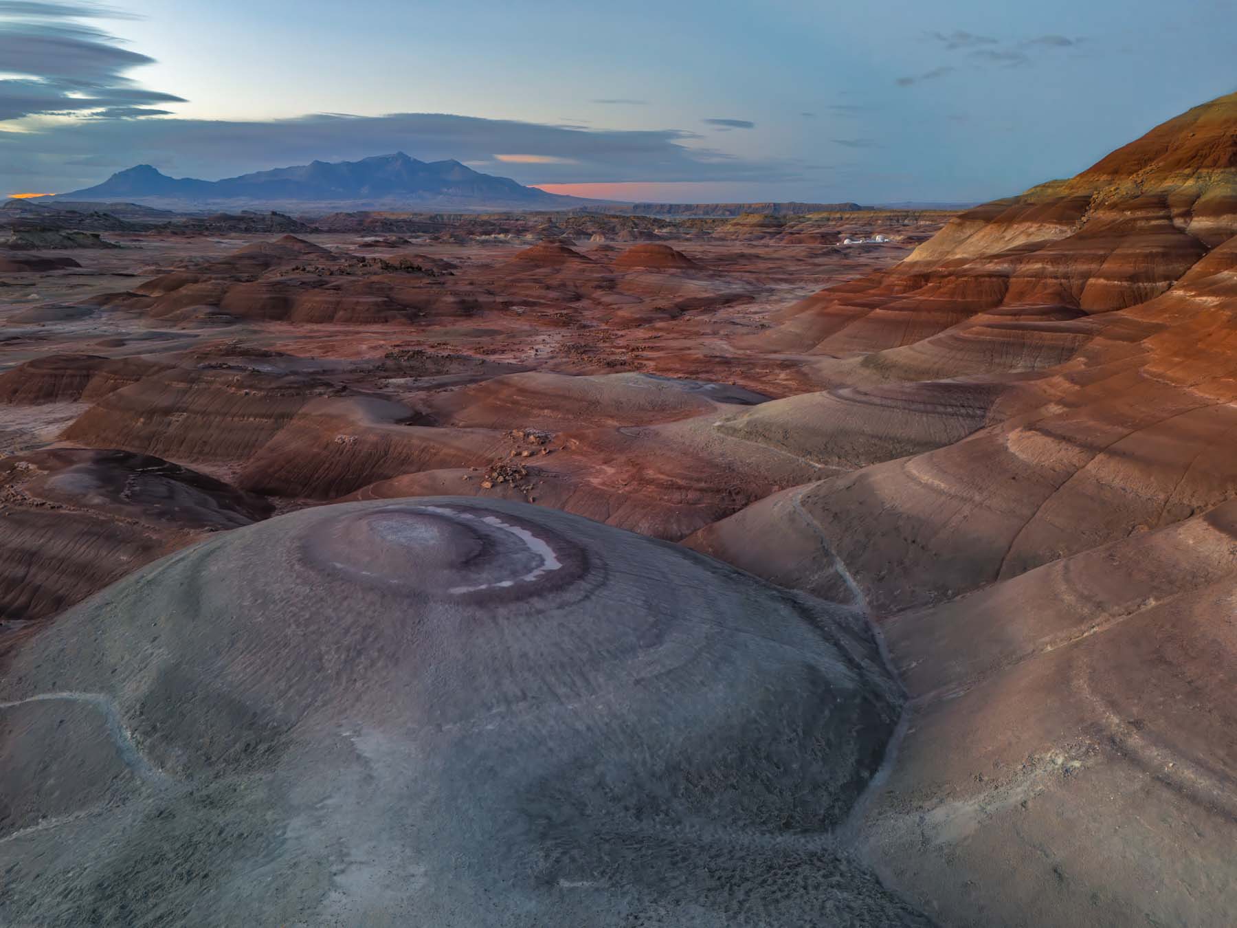
Drone photo of the New Bentonite Hills
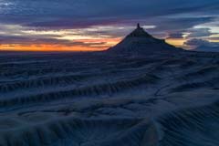
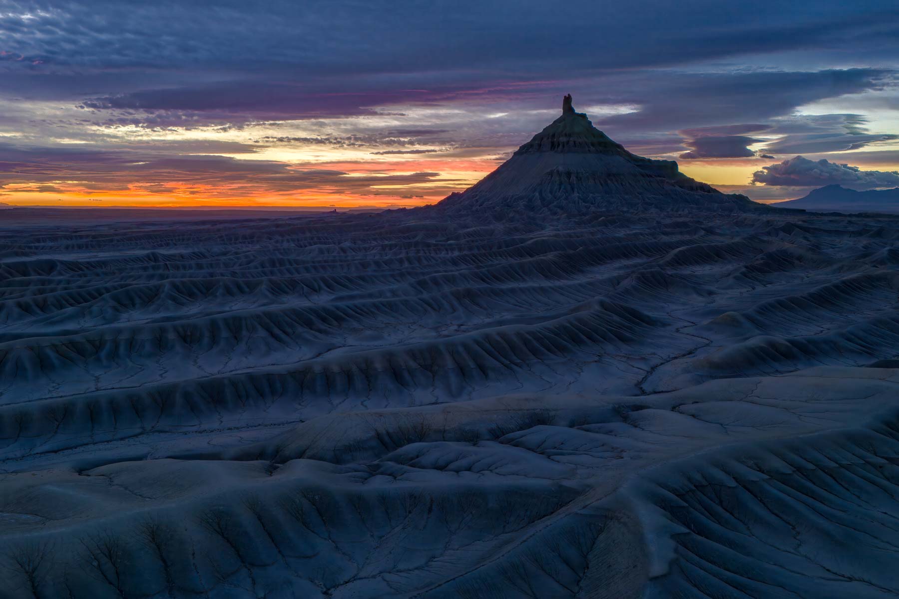
Drone photo of Factory Butte
Drones are revolutionizing the field of landscape photography. They enable photographers to capture breathtaking aerial shots that showcase the earth from a bird's-eye view. These perspectives provide a sense of scale, depth, and intricacy, offering viewers a fresh and captivating look at familiar landscapes. By employing drones, photographers can explore new angles and compositions, revealing the beauty of nature in once-impossible ways.
One of the most compelling aspects of using drones in landscape photography is the ability to reach remote or inaccessible areas. Drones can navigate rugged terrains, hover over bodies of water, and ascend to considerable heights. Drones allow photographers to capture images of landscapes that would otherwise be challenging or dangerous to access. Whether it's an inaccessible arch or ruin, a cascading waterfall, or a sprawling coastline, drones empower photographers to portray their beauty with unparalleled detail and perspective.
The maneuverability of drones allows for experimentation with various angles, elevations, and movements, enabling photographers to compose striking and dynamic shots. Additionally, advancements in drone technology, such as high-resolution cameras and stabilizing features, ensure the capture of high-quality images and videos. This technological innovation empowers photographers to produce visually stunning and immersive content that captivates audiences and conveys the awe-inspiring grandeur of natural landscapes.
Drone limitations
People dislike drones. This dislike stems from factors that touch upon privacy concerns, noise pollution, safety issues, and intrusion of personal space. Privacy invasion is a prominent reason for the disdain of drones. The ability of drones to fly over private properties and capture images or videos without consent raises legitimate privacy concerns for individuals. Additionally, the buzzing sound emitted by drones can disrupt the peace and tranquility of an area, annoying people nearby. Safety is another significant issue, as irresponsible drone operations can pose risks of collisions with aircraft, endangering lives. Furthermore, many people perceive drones as intrusive devices that can be used for surveillance or unethical purposes.
Drones can only be used in some areas. Takeoff, landing, and operation are prohibited in U.S. national parks unless a specific permit has been obtained for research or exceptional circumstances approved by the park authorities. Drones can't take off, land, or be operated in U.S. wilderness areas. You can partially avoid this prohibition by taking off outside the wilderness area and then flying over it. Drones must remain in sight when operated, however. Many state parks prohibit or restrict the use of drones. Before you fly a drone in the U.S., you should use the b4ufly app to determine whether flying is prohibited. B4UFLY is the official airspace safety application of the FAA. The app is available for Apple, Android, and Windows. The syntax to check a location in Windows is "https://b4ufly.aloft.ai/?lat=34.7860168&long=-111.7495536," for example.
The DJI Mini Pro 4
I have begun using a DJI Mini Pro 4 to capture landscapes. The DJI Mini 4 Pro excels amongst its drone counterparts due to its compact size (less than 250 grams), portability, and advanced features. Its lightweight design ensures easy transport for outdoor shoots, while its stable flight controls and precise GPS contribute to steady aerial shots. With a 48-megapixel camera system offering 4K video capabilities and extended battery life, photographers can capture vivid landscapes with rich colors and sharp details, allowing longer shooting sessions. Even drone beginners like myself can safely operate the drone thanks to its built-in obstacle avoidance and return-to-home features.
One of the things I like best about the DJI Mini Pro 4 is the metadata and flight logs it produces. DJI drones create files in DNG format, readable by Lightroom. Metadata in the DNG file includes GPS coordinates, absolute and relative altitudes, the direction the camera was facing, and its pitch. I wish all cameras had these features. Note that Lightroom does not show relative altitude or the direction the camera was facing in its metadata display. You can view them in Exiftool or Exiftoolgui, however. The Gimbal Yaw entry shows the direction in which the camera was facing. Relative altitude is relative to the takeoff point.
DJI drones produce very detailed flight logs. They are automatically uploaded to DJI servers when the controller is connected to the web. The logs are in a machine format. The website airdata.com can read these logs and convert them to text. Outputs include:
- An overview of the flight.
- Downloadable KML files with the flight track.
- Data about the images taken.
A free Airdata account will keep up to 100 flights in the Airdata database. The major downside to a free account is that it can take a few days before flight logs are available after they have been uploaded to DJI.
While the DJI Mini 4 Pro is a versatile and capable drone, there are some limitations for landscape photography:
Sensor Size: The Mini 4 Pro has a 1/2.3-inch sensor. Compared to the larger sensors found in professional cameras, this sensor has limited dynamic range and low-light performance. The 1/2.3-inch sensor impacts the level of detail and quality achievable, particularly at dawn or dusk. The Mini Pro 4 can shoot 12 or 48-megapixel images. I shoot all of my pictures in RAW 48-megapixel mode. You can set RAW and 48-megapixel as defaults in Settings Camera on the controller. Also, set 4/3 as the Aspect ratio, the sensor's aspect ratio. The 48-megapixel mode images are created by pixel shifting; the camera's sensor is 12 megapixels.
In low light, the 48-megapixel mode produces a fair amount of chroma noise in the shadows. Proper exposure is vital to avoiding noise. I shoot most of my images using DJI's HDR mode. When shooting 12-megapixel photos, you can select between 3, 5, or 7 exposures one stop apart in the Settings menu on the controller. For 48-megapixel images, brackets consist of three images. You can't change the number of pictures in a bracket to 5 or 7. You must manually bracket if you need more than three images one stop apart to capture the full dynamic range of the setting. I usually set exposure compensation to -0.3 or -0.7 EV. I also use Lightroom's Denoise (under Photo Enhance) to remove noise. I sometimes create a manual panorama to increase image detail. The left control stick makes it easy to shoot a horizontal panorama. You can rotate the gimbal dial to create a vertical panorama. I do not usually use the drone's automatic pano feature.
- Limited Camera Adjustability: The camera on the Mini 4 Pro lacks the flexibility of interchangeable lenses and the manual controls often found in higher-end drones or dedicated cameras. This limitation can restrict the ability to fine-tune settings like aperture or shutter speed for specific photographic needs.
- Fixed Aperture Lens: The Mini Pro 4 has a fixed aperture of f/1.7. At f/1.7 and 24mm the hyperfocal distance is 7 feet. When focused at the hyperfocal distance landscape images will be in sharp focus unless your subject is closer than 3.5 feet. Unfortunately, this aperture and the 1/2.3" sensor size make it difficult to blur the background and generate creative effects. The fixed aperture also makes it challenging to blur waterfalls. AT typical shutter speed for blurring water is 1/3 second. On a sunny day at f/1.7 1/3 second, ISO 100, a neutral density filter of more than 11 stops is required to avoid over-exposing the highlights. A ten stop ND is currently the darkest available ND filter for the Mini Pro 4.
- Fixed Field of View (FOV): The Mini 4 Pro has a fixed lens with a full frame equivalent focal length of 24mm, limiting the range of perspectives compared to drones with adjustable focal lengths or multiple cameras. The fixed lens can be a constraint when trying to capture diverse compositions or needing a specific field of view for certain shots. At least a wide-angle converter with an effective focal length of 14mm is available.
Wind Susceptibility: The Mini 4 Pro is more susceptible to wind than larger, more robust drones due to its lightweight design. It's rated for winds up to 24 mph. Don't fly when gusts reach this level. Wind speed has a significant impact on drones and can affect their performance and stability in various ways:
- Flight Stability: Higher wind speeds can cause drones to be less stable in the air.
- Control and Maneuverability: Strong winds can make controlling the drone's movements challenging. Pilots may experience difficulty steering or keeping the drone on a desired flight path.
- Battery Life: Flying against strong winds requires the drone to exert more power, resulting in increased energy consumption. Strong winds lead to quicker battery drainage and reduced overall flight time.
- Risk of Damage or Loss: In very high winds, drones might struggle to maintain stability, potentially leading to crashes or loss of the drone due to being carried away by the wind.
- Camera Stability: Wind can affect the stability of the camera mounted on the drone, potentially impacting the quality of images or videos captured. It might result in shaky footage or blurred images due to movement caused by wind-induced vibrations. Night photography is impossible with drones. To mitigate the impact of wind on drones, pilots should:
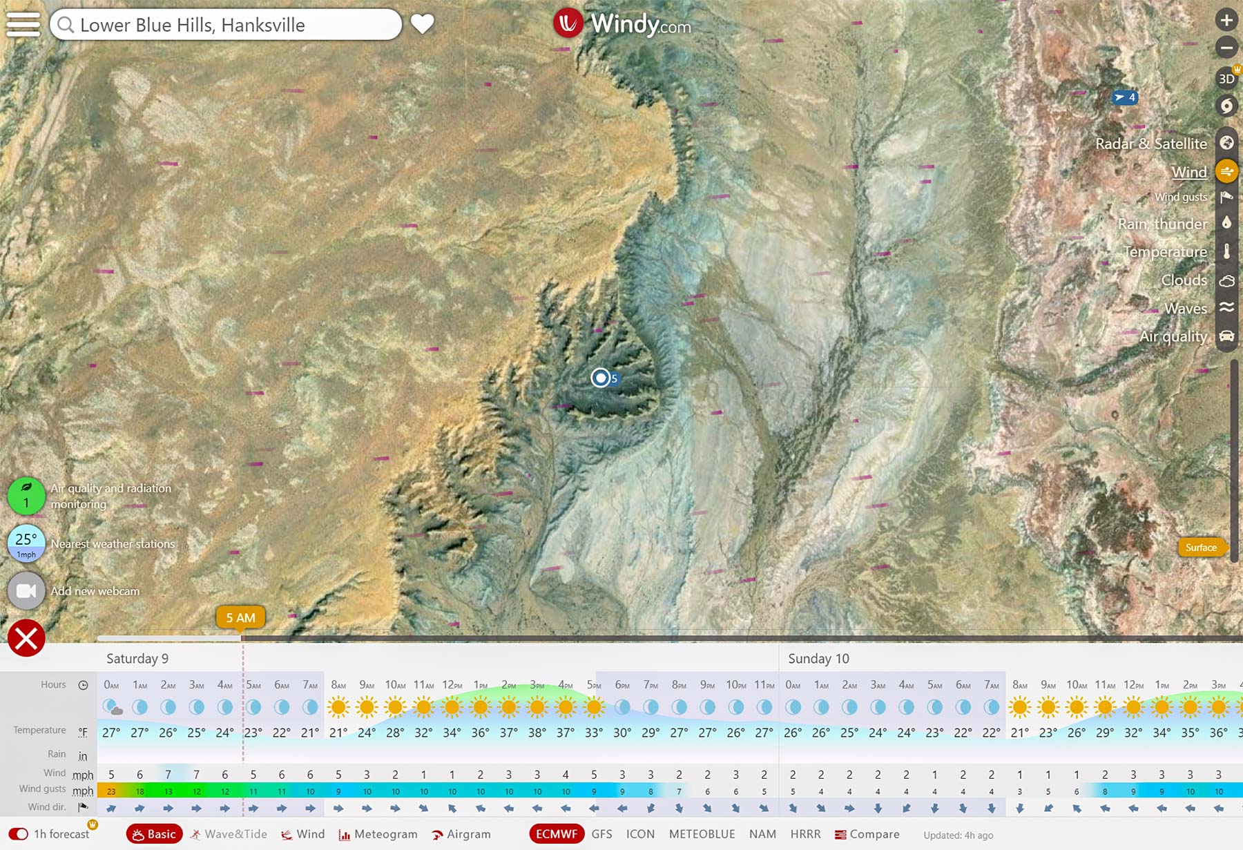
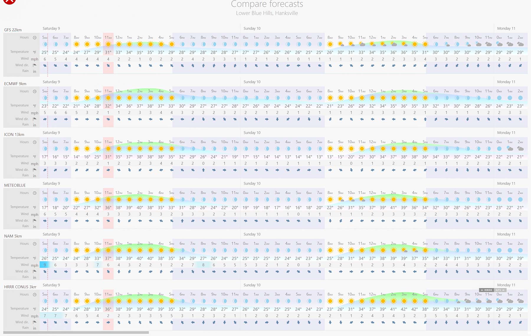
- Check weather conditions before flying and avoid high wind speeds exceeding the drone's recommended limits. I use windy.com to check forecast wind speeds. Windy.com shows average wind speed and wind gusts for four days (in the free version and ten days with a premium subscription. Various forecasts are available, including ECMWF, HRRR, GFS, NAM, METEOBLUE, and ICON. Forecasts in the Premium version are hourly and updated four times a day. Snowfall and snow depth are also available. Tide and swell forecasts are available for any point on the coast, not just at tidal stations. Over time, I will add windy.com links to the predefined locations on this site's sunrise/sunset pages.
- The drone's controller clearly shows a red streak when the wind is excessive; avoid flying then.
- Fly the drone at lower altitudes or in more sheltered areas to minimize exposure to strong winds.
- Use caution and adjust flight maneuvers to maintain control and stability when encountering windy conditions.
- If you are having trouble returning home, fly at an angle to the wind (tack) instead of flying directly into it.

Windy.com ECMWF forecast at Long Dong Silver
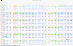
Windy.com Forecast Comparison
- The DJI Mini Pro 4 is new. DXO Raw does not yet support it. More importantly, the drone cannot yet import KML or GPX files and use them to fly predetermined routes. Nor can it automatically take photos over a grid and merge them to create a high-resolution image of an area. Some third-party apps, such as Litchi and Dronelink, have these features. Litchi and Dronelink are not yet available for the Mini Pro 4. It may be quite a while before they are.
In the future
I will gradually update this website to make it more "Drone Friendly." Enhancements will include:- Revisiting sites with an emphasis on drone photography.
- Adding overview videos of sites.
- Photos taken with a drone will have the word "Drone" in the keywords.
- Maps will be modified to show National Park and Wilderness Boundaries.
- Sunrise/Sunset webpages will be adjusted to include links to Windy.com.
- The use of drones for light painting will be explored.